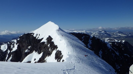
Kebnekaise's south peak photographed from the north peak on August 9th. Photographer Gunhild Rosqvist.
The south peak is covered by a small glacier which is now about forty metres thick. Its height varies in accordance with the changes over time in the size of the glacier. Until the late 1990s the height varied between 2110-2120 metres above sea level. In the early 2000s, the height dropped to 2006 metres above sea level and since then it has fallen about 0.5 m per year, with some variation.
The height also varies during the course of the year. At the end of the winter, in April-May, it reaches its maximum height, and then the normal August value is around two metres lower. The lowest altitude is reached in September, when it can be up to a metre lower than in August. The year's average height measurement yielded a record low 2,100 metres above sea level, which means that the peak is only three metres higher than its neighbor, Kebnekaise's north peak.
With the current warm climate, we will, within a few years, need to get accustomed to the country's highest peak alternating between the two Kebnekaise peaks, and if the trend continues, the north peak will within a decade definitely be the highest point. The north peak is solid rock with a cairn on top.
Text: Per Holmlund, professor of glaciology