
Tracking the rapid pace of a retreating ice sheet
Martin Jakobsson. Science, 29 May 2020: Vol. 368, Issue 6494, pp. 939-940 DOI: 10.1126/science.abc3583
Summary:
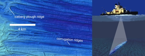
Glaciers and ice sheets that extended from land into the ocean left traces behind on the seafloor called submarine glacial landforms. If mapped in sufficient detail and interpreted correctly, they can provide comprehensive information into past behaviors of glaciers and ice sheets. On page 1020 of this issue (Science: May 29, 2020, Vol 368), Dowdeswell et al. (1) describe the mapping of glacial landforms in the seafloor created by a rapidly retreating ice sheet on the eastern Antarctic Peninsula. The high-resolution data suggest that the retreat rate was paced by ocean tides and at least an order of magnitude faster than modern rates observed in other sensitive areas, such as West Antarctica where the ice sheet drains into the ocean at several locations. The retreat on the eastern Antarctic Peninsula took place more than 10,000 years ago, pointing out the challenges in predicting the sea-level rise contribution from retreating glaciers and ice sheets in a warming climate.
References and links to articles
(1) Dowdeswell, J. A., Batchelor, C. L., Montelli, A., Ottesen, D., Christie, F. D. W., Dowdeswell, E. K., and Evans, J., 2020, Delicate seafloor landforms reveal past Antarctic grounding-line retreat of kilometers per year: Science, v. 368, no. 6494, p. 1020-1024. Doi: 10.1126/science.aaz3059
https://science.sciencemag.org/content/368/6494/1020
(2) Jakobsson, M., 2020, Tracking the rapid pace of a retreating ice sheet: Science, v. 368, no. 6494, p. 939-940. Doi: 10.1126/science.abc3583
https://science.sciencemag.org/content/368/6494/939
(3) Jakobsson, M., Anderson, J. B., Nitsche, F. O., Dowdeswell, J. A., Gyllencreutz, R., Kirchner, N., O’Regan, M. A., Alley, R. B., Anandakrishnan, S., Mohammad, R., Eriksson, B., Fernandez, R., Kirshner, A., Minzoni, R., Stolldorf, T., and Majewski, W., 2011, Geological record of Ice Shelf Breakup and Grounding Line Retreat, Pine Island Bay, West Antarctica: Geology, v. 39, no. 7, p. 691-694.
 Geo Science Building