Imenne ÅhlénDoktorand
Om mig
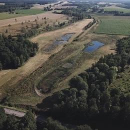
I am a PhD-student since 2018 working on a project about wetlands. My research involves developing the understanding of hydrological characteristics of wetlands and wetlandscapes (i.e. interconnected wetlands in the landscape) and connecting this to nutrient characteristics and biodiversity support. One part of my research is being out in the field collecting data, where my current field campaings are in Sweden and Colombia. Apart from research, I am also a teaching assistant in different master and bachelor level courses, mostly related to hydrology.
Forskningsprojekt
Publikationer
I urval från Stockholms universitets publikationsdatabas
-
Wetlandscape size thresholds for ecosystem service delivery
2020. Imenne Åhlén (et al.). Science of the Total Environment 704
ArtikelLäs mer om Wetlandscape size thresholds for ecosystem service deliveryWetlands are interconnected with the larger surrounding landscape through the hydrological cycling of water and waterborne substances. Therefore, the borders of individual wetlands may not be appropriate landscape system boundaries for understanding large-scale functions and ecosystem services of wetlandscapes (wetland network - landscape systems), and how these can be impacted by climate and land-use changes. Recognizing that such large-scale behaviours may not be easily predicted by simple extrapolation of individual wetland behaviours, we here investigate properties of 15 Swedish wetlandscapes in the extensive (22 650 km(2)) Norrstrom drainage basin (NDB) comprising as many as 1699 wetlands. Results based on wetland survey data in combination with GIS-based ecohydrological analyses showed that wetlands located in wetlandscapes above a certain size (in the NDB: similar to 250 km(2)) consistently formed networks with characteristics required to support key ecosystem services such as nutrient/pollutant retention and biodiversity support. This was in contrast to smaller wetlandscapes (<250 km(2)), which had smaller and less diverse wetlands with insufficient throughflow to significantly impact large-scale flows of water and nutrients/pollutants. The existence of such wetlandscape-size thresholds is consistent with scale-dependent flow accumulation patterns in catchments, suggesting likely transferability of this result also to other regions.
-
Priorities and Interactions of Sustainable Development Goals (SDGs) with Focus on Wetlands
2019. Fernando Jaramillo (et al.). Water 11 (3)
ArtikelLäs mer om Priorities and Interactions of Sustainable Development Goals (SDGs) with Focus on WetlandsWetlands are often vital physical and social components of a country's natural capital, as well as providers of ecosystem services to local and national communities. We performed a network analysis to prioritize Sustainable Development Goal (SDG) targets for sustainable development in iconic wetlands and wetlandscapes around the world. The analysis was based on the information and perceptions on 45 wetlandscapes worldwide by 49 wetland researchers of the Global Wetland Ecohydrological Network (GWEN). We identified three 2030 Agenda targets of high priority across the wetlandscapes needed to achieve sustainable development: Target 6.3-Improve water quality; 2.4-Sustainable food production; and 12.2-Sustainable management of resources. Moreover, we found specific feedback mechanisms and synergies between SDG targets in the context of wetlands. The most consistent reinforcing interactions were the influence of Target 12.2 on 8.4-Efficient resource consumption; and that of Target 6.3 on 12.2. The wetlandscapes could be differentiated in four bundles of distinctive priority SDG-targets: Basic human needs, Sustainable tourism, Environmental impact in urban wetlands, and Improving and conserving environment. In general, we find that the SDG groups, targets, and interactions stress that maintaining good water quality and a wise use of wetlandscapes are vital to attaining sustainable development within these sensitive ecosystems.
-
Effects of Hydroclimatic Change and Rehabilitation Activities on Salinity and Mangroves in the Cienaga Grande de Santa Marta, Colombia
2018. Fernando Jaramillo (et al.). Wetlands (Wilmington, N.C.) 38 (4), 755-767
ArtikelLäs mer om Effects of Hydroclimatic Change and Rehabilitation Activities on Salinity and Mangroves in the Cienaga Grande de Santa Marta, ColombiaThe Cienaga Grande de Santa Marta (CGSM), Colombia is possibly the wetland that has experienced the largest mangrove mortality on record due to modification of hydrologic connectivity and consequent hypersaline conditions. We used hydroclimatic, salinity and mangrove basal area data collected in five stations from 1993 to 2015 to study the relation between ongoing mangrove recovery, changes in salinity in the wetland and hydroclimatic changes in precipitation, potential evapotranspiration and freshwater inputs. We found that until 2015, the mangrove ecosystems in CGSM are in general terms in a path of recovery due to the combined effect of favorable hydroclimatic conditions and management operations to increase freshwater inputs into the wetland. We observed in three stations that the annual growth of mangrove basal area increased as pore water salinity decreased. Regarding surface water salinity, El Nino/Southern Oscillation explained most of the inter-annual variability in the wet season by regulating freshwater and in the dry season by regulating potential evaporation from the wetland. However, persistent channel reopening appeared to be the cause for the largest salinity decreases, whereas lack of persistent dredging slowed recovery in other areas. The monitoring of the mangrove-salinity-hydroclimate system must continue in order to increase its understanding and to avoid more recurring episodes of mangrove mortality.
-
Global Assessment of Accountability in Water and Sanitation Services Using GLAAS Data
2018. Alejandro Jiménez (et al.). Water Alternatives 11 (2), 238-259
ArtikelLäs mer om Global Assessment of Accountability in Water and Sanitation Services Using GLAAS DataThe Global Analysis and Assessment of Sanitation and Drinking-Water (GLAAS) is one of UN-Water's regular reports. Its focuses include aspects of investment and the enabling environment for the delivery of water, sanitation and hygiene services. Accountability refers to the mechanisms through which duty bearers, elected officials and service providers report to rights holders and other stakeholders within the service delivery framework. Accountability contributes to good sector performance and the overall sustainability of services. The aim of this study was to evaluate the level of accountability in the drinking-water and sanitation sector globally, based on the available data from the GLAAS survey of 2014. To achieve this, accountability was defined from a human rights perspective, and particularised for water and sanitation. Next the quantitative and open-ended questions from the GLAAS survey that related to this definition were analysed for all 94 responding countries. Comparisons were drawn between water and sanitation services in urban and rural settings, and regional trends were identified. The results show higher levels of accountability for water than sanitation services, and limited information on wastewater. Potential means to strengthen accountability in water and sanitation globally are seen to include improving access to information on the services provided, enacting participation policies and increasing the capacity of regulatory institutions. Particular attention should be paid to rural services. The GLAAS survey could be modified for a better understanding of the accountability mechanisms for WASH service provision.
-
Data for wetlandscapes and their changes around the world
2020. Navid Ghajarnia (et al.). Earth System Science Data 12 (2), 1083-1100
ArtikelLäs mer om Data for wetlandscapes and their changes around the worldGeography and associated hydrological, hydroclimate and land-use conditions and their changes determine the states and dynamics of wetlands and their ecosystem services. The influences of these controls are not limited to just the local scale of each individual wetland but extend over larger landscape areas that integrate multiple wetlands and their total hydrological catchment - the wetlandscape. However, the data and knowledge of conditions and changes over entire wetlandscapes are still scarce, limiting the capacity to accurately understand and manage critical wetland ecosystems and their services under global change. We present a new Wetlandscape Change Information Database (WetCID), consisting of geographic, hydrological, hydroclimate and land-use information and data for 27 wetlandscapes around the world. This combines survey-based local information with geographic shapefiles and gridded datasets of large-scale hydroclimate and land-use conditions and their changes over whole wetlandscapes. Temporally, WetCID contains 30-year time series of data for mean monthly precipitation and temperature and annual land-use conditions. The survey-based site information includes local knowledge on the wetlands, hydrology, hydroclimate and land uses within each wetlandscape and on the availability and accessibility of associated local data. This novel database (available through PANGAEA https://doi.org/10.1594/PANGAEA.907398; Ghajarnia et al., 2019) can support site assessments; cross-regional comparisons; and scenario analyses of the roles and impacts of land use, hydroclimatic and wetland conditions, and changes in whole-wetlandscape functions and ecosystem services.
-
Hydro-climatic changes of wetlandscapes across the world
2021. Imenne Åhlen (et al.). Scientific Reports 11 (1)
ArtikelLäs mer om Hydro-climatic changes of wetlandscapes across the worldAssessments of ecosystem service and function losses of wetlandscapes (i.e., wetlands and their hydrological catchments) suffer from knowledge gaps regarding impacts of ongoing hydro-climatic change. This study investigates hydro-climatic changes during 1976–2015 in 25 wetlandscapes distributed across the world’s tropical, arid, temperate and cold climate zones. Results show that the wetlandscapes were subject to precipitation (P) and temperature (T) changes consistent with mean changes over the world’s land area. However, arid and cold wetlandscapes experienced higher T increases than their respective climate zone. Also, average P decreased in arid and cold wetlandscapes, contrarily to P of arid and cold climate zones, suggesting that these wetlandscapes are located in regions of elevated climate pressures. For most wetlandscapes with available runoff (R) data, the decreases were larger in R than in P, which was attributed to aggravation of climate change impacts by enhanced evapotranspiration losses, e.g. caused by land-use changes.
Visa alla publikationer av Imenne Åhlén vid Stockholms universitet