
February–March 2010
![]()
![]()
![]()
![]()
![]()
![]()
![]()
![]()
![]()
![]()
![]()
![]()
![]()
![]()
![]()
![]()
![]()
![]()
![]()
![]()
![]()
![]()
![]()

February 3: Arrival to Christchurch, New Zealand

After 27 hours in the air and stops in London, Bangkok, and Sydney we arrived in Christchurch, New Zealand around 15:00 local time. The weather was excellent with a pleasant temperature around 20 °C, only a few scattered clouds and a light breeze. The United States Antarctic Program (USAP) has for many years utilized Christchurch as their main gateway to Antarctica and as a point of logistical support for their Antarctic research activities; it began in 1955 with the well known “Operation Deep Freeze”. Since our project with icebreaker Oden is a Swedish/US collaboration we benefitted from the USAP organization. We were collected with a pre-ordered Shuttle bus at the airport and transported to the Windsor Bed & Breakfast Hotel were all of us from Stockholm University were going to stay. With 12 hours jet lag, it was indeed a challenge for most to stay away until the evening! But it was worth it as we got a chance to go to the well known pub Baileys where, according to what we were told, both Sir Ernest Shackleton and Robert Scott had farewell dinners before going out on their famous expeditions.
![]()
February 4: Gearing up for cold weather conditions

The USAP logistical center is located near the Christchurch airport. Our main mission this day was to go to the USAP logistical center to try out the required clothing for the flight next morning. We had in advance sent down our cloth sizes so there were one bag for each of us neatly packed with all the required “Extreme Weather Clothes”, as USAP are calling them. After going through various luggage restrictions for the flight from Christchurch to McMurdo tomorrow, we were informed that we had to be at the USAP logistical center 04:30 in the morning! But the good news was that they intend to fly us down with the giant plane C-17. This plane can take cars inside!
![]()
February 5: From Christchurch to McMurdo, Antarctica

The shuttle bus from Hotel Windsor Bed & Breakfast to the airport was scheduled to leave 4:15 in the morning. This would give us enough time to change to the mandatory ECW clothes and check in for the C-17 flight scheduled to leave 06:00. Sometime after 03:00, the manager of the Hotel knocked on our doors and informed us that the flight was delayed three hours; we could sleep in until 06:00. Some minutes later, new instructions. The flight was only going to be two hours delayed, we had to go up and get ready rather soon. Indeed impressive how involved the management of this hotel is in the logistics surrounding Antarctic research! The C-17 flight finally left some time after seven and we were on the route to Antarctica. Occasionally they have to do what is referred to as a "boomerang flight". This is when the landing conditions are too bad in McMurdo so they have to turn around and head back to Christchurch. The record of boomerang flights is eight in a row! This says something about McMurdo's fast shifting weather conditions. We did not need to turn back and landed on the ice Ross Ice shelf near McMurdo five hours later. We were transported by the terrain vehicle "Ivan" across the ice to McMurdo passing New Zealand's Scott station. From McMurdo we were directly transported with Hägglunds bandwagons to Oden that was docked along the sea ice edge some kilometer outside of McMurdo. When we arrived to Oden penguins and seals greeted us. Indeed a day filled with action!


![]()
February 6: Multibeam mapping the entrance to McMurdo
Already during the evening on the day of our arrival to McMurdo we could begin multibeam mapping outside of Ross Island. This was because /Oden/ had to clean more ice out of the passage they had been working to break up the weeks before we arrived. This gave us a superb opportunity to setup our mapping routines. Since we map around the clock, we have to work in shifts. /Oden/ is contracted by the US National Science Foundation (NSF) to break up a passage in the sea ice around Ross Island where the McMurdo station is situated. The passage makes it possible for supply ships to reach McMurdo. After their mission is over our expedition will officially begin.

The multibeam data we collected while /Oden/ was cleaning the passage were of very high quality and since we passed the same part of the seafloor several times with the multibeam, we could grid our data at much higher resolution than otherwise possible. We discovered several glacial features not previously described from this area. This will provide new information on the past ice sheet extensions and considering that we had not counted on that any science would be done before the departure from McMurdo on the 8th, it felt like a real bonus. It turned out that the McMurdo management was also very interested in our data since the available navigational charts near the station are far from detailed. While we were mapping and cleaning the passage from ice, numerous Killer Whales patrolled along the ice edge. They seemed to hope for that some of the numerous penguins and seals on the sea ice felt for a dip in the water.


![]()

The clearance of the passage through the sea ice into McMurdo station was completed in the morning so we returned to the ice pier with /Oden/. Before we could dock at the pier /Oden/ had to guide out the cargo ship American Tern to ice free water. On our way back to the pier after the /American Tern/ was left safely outside of the sea ice, we stopped and docked along the sea ice edge of the passage so Lars-Anders Hansson and his group from Lund University could take water samples down to 80 m water depth. They study zooplanktons and their project involves sampling of water along the expedition route so they can study these planktons. More specifically, they like to know how zooplanktons handle their two main threats: exposure from ultraviolet (UV) radiation and predation. They have found that zooplanktons are able adjust the photoprotective pigmentation in accordance with the present UV threat, the copepods (a type of Zooplankton) the look at turn more red the shallower they live in the water column to cope with the UV radiation. But this increases the risk for them to be seen and eaten.
The return to McMurdo provided an opportunity to make a visit to the station where they off course have souvenir shop with T-shirts, mugs, various pins etc. Most of the scientist took this opportunity. The group from Stockholm University walked up on the so called "Observation hill", a small 250 m high mountain peak. The view from this point is magnificent. It is possible to see the nearby New Zealand Scott Base as well as the landing field on the Ross Ice Shelf.


![]()

To take sediment cores with our large piston corer and to be able to deploy other heavy research equipment from /Oden's/ aft deck, an A-Frame was installed in 1996. This A-frame was taken down before the transit across the Atlantic from Helsingborg to Montevideo to avoid damages in heavy seas. In order to mount the A-frame again, support from a large crane is required as it weigh more than two tons. A mobile crane available in McMurdo was going to assist and the crane was scheduled to arrive at the ice pier 08:00 in the morning. This entire operation went very smooth and after the A-frame was in place, we could begin installed the coring equipment on the aft deck. While they were working on mounting the A-frame, we visited Scott's hut in McMurdo. Everything in the hut was left as it once was found after Scott and his men had been there. This included the meat they had stored from seals and whales and a last meal was still in the frying pan!


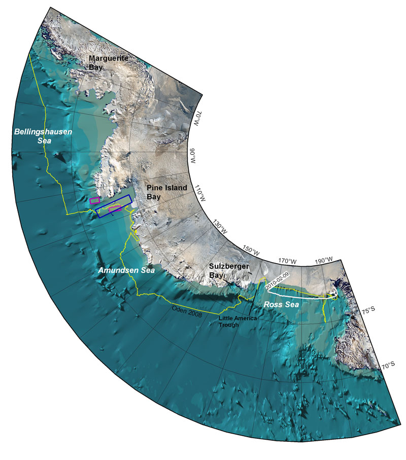
We left McMurdo at 18:00 to steam towards the first working area, the Little America Trough located in the eastern part of the Ross Sea. The oceanographers onboard will investigate whether relatively warm water is flowing onto the Antarctic continental shelf in this trough. The Antarctic continental shelf surrounding the continent is filled with deep troughs that have been formed from ice age periods when the ice sheets extended further out and were larger than today. During the transit we began setting up the coring equipment. We plan to take both piston cores and so called Kasten cores. A big tent, looking like a robust party tent, was raised and secured on the aft deck. It was bitterly cold to work and the tent seems like a very good idea.

![]()
February 9: Transit across the Ross Sea
The transit towards the eastern Ross Sea had begun and we passed some first plateau icebergs. The wind was rather calm but it was still very cold to work on the aftdeck. We tried to map the depths of some icebergs with our multibeam sonar by passing close to them. If the icebergs are deep enough they should interfere with the outer beams and show up particularly well in the sonar's water column registration. Both the icebergs we passed close (approximately 500 m away) were too shallow to show up on the sonar display. Since the opening angel of the acoustic beams is 65 degrees, the icebergs need to be deeper than 233 m below sea level to show up on the sonar.


![]()
February 10: Across the Ross Sea
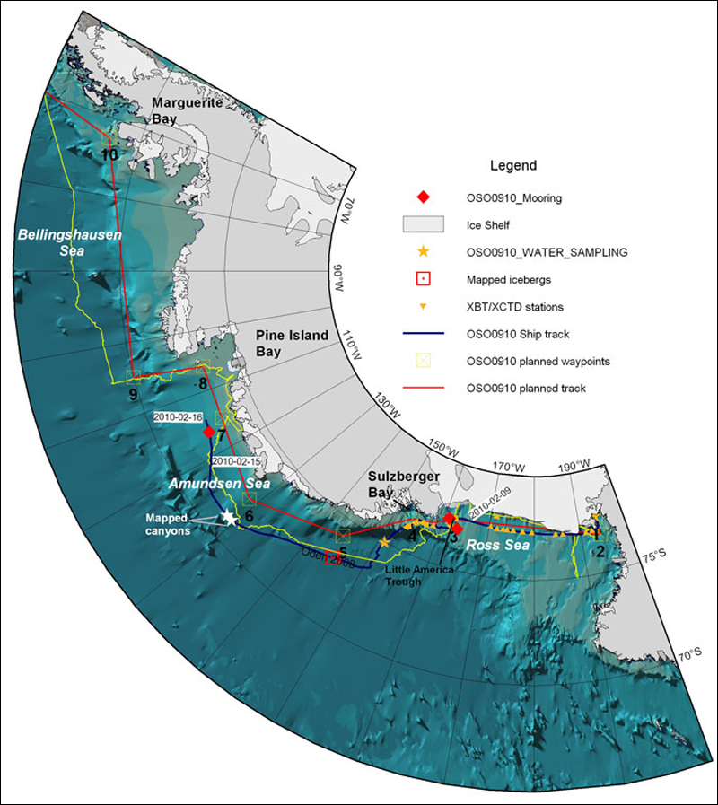
We reached our working area in the Little America Trough during the middle of the day. Before we could deploy the first mooring for the oceanographic project the bottom topography (bathymetry) had to be surveyed with our multibeam sonar. The goal was to deploy the mooring in a water depth of 650 m. The mooring consists of an anchor made from a heavy train wheel and a wire to which oceanographic instruments are attached. The wire with the instruments is then held up by buoys that float. This mooring, equipped with the oceanographic instruments logging water temp, salinity and current speed, is going to be left to record data over a year. The first oceanographic mooring was deployed 08:14 UTC; 20:14 in the evening our ship time. The operation went very smooth considering it was the first time such a mooring was deployed from the /Oden/.
![]()
February 11: Sailing through an iceberg graveyard
The second mooring was deployed in the early morning and we continued towards the next way point located outside of Sulzberger Bay. The mooring deployment went very well and even faster than the first time. The site was located in the inner part of the Little America Trough for the main purpose of finding out if any warm water is ever entering here to flow towards the Ross Ice Shelf. The route from Little America Trough to Pine Island Bay will entirely be decided depending on the sea ice conditions. We passed an area with abundant large icebergs around three in the afternoon, some clearly grounded on the less than 300 m deep sea floor. It felt like passing an "iceberg graveyard" and the fog added to this feeling. We went close enough to one of these icebergs so it could be seen covering the outer beams of the multibeam sonar.


![]()
February 12: Heading towards Pine Island Bay
During the next days we will be in transit to the Pine Island Bay. Since we came onboard all have been occupied with setting up the scientific equipments and preparing for sampling of water, sediment and measuring sediment physical properties. All this is now completed and we plan for a first sediment coring station located somewhere on the way to Pine Island Bay. The purpose of taking this core is to get some sediment to try out our sampling routines and multi sensor core logger (MSCL). This MSCL is setup in the sediment lab behind the foredeck. Matt O'Regan has been busy fine tuning the MSCL and making sure it is well calibrated before we, hopefully, get lots of cores to measure from our main study area, the Pine Island Bay.


![]()
February 13-16: "Looong transit" towards Pine Island Bay
Antarctic is a huge continent and the distance from McMurdo to Pine Island Bay is long, very long. We have travelled over 1600 nautical miles since February 8. The enormous plateau icebergs are competing with amazing seafloor morphology to be the most spectacular events during this transit. We have passed some striking canyons carved by currents in the more than 3800 m deep abyssal plain. These canyons were portrayed in fantastic detail by our Konsgberg SB120 chirp sonar subbottom profiling system. During the night of the 16th , we reached the site where the mooring for the Gothenburg University group, led by Göran Björk and Anna Wåhlin, was going to be deployed. The setup of this mooring is similar to the previous moorings so the crew and oceanographers onboard were already used to deploy these types from the /Oden/. The mooring went successfully into the water at 14:40 UTC, that is 02:40 in the night our ship time. The site was not too far away from some very large plateau icebergs. Directly after the mooring deployment we planned to take a CTD (Conductivity, Temperature and Depth measurements). The CTD winch had not been working "erly since we left McMurdo, probably due to damages caused by the severe storm /Oden/ went through on her way from Helsingborg to Montevideo. The technicians onboard have been working on the winch and got it working. But despite all of the maintenance, the winch decided to stop at 300 m and refused to go no further! After some tricks by the skillful technicians from the /Oden/ crew, the CTD could be winched back up on deck. But the CTD profile only covered the upper 300 m of the water column while we wanted to profile to a water depth of 550 m. After the CTD was recovered it was time for us to, for the first time, try the "Kasten corer". This is a square gravity corer; simply a 3 m long and 15x15 cm square box in stainless steel that has a heavy led weight on top. This box is then pushed through the seafloor and, hopefully, it samples the uppermost 3 m of sediments.

The handling of this corer went very smooth. Since this was a first test run, we had not bothered to survey for a coring site with lots of sediments. The area we cored at had a very hard bottom and only some 10 cm of stiff sandy clay was recovered. Not at all unexpected considering that this part of the shallow (ca 450 m deep) continental shelf has been overridden by ice sheet during glacial periods and thick icebergs have subsequently plowed the bottom as well. After the coring we continued towards Pine Island Bay. We passed some penguins that had walked up on a small snow hill on the sea ice to escape from a nasty seal; it looked like a leopard seal!


![]()
We were finally in Pine Island Bay. The weather was perfect with calm winds from south east and very little sea ice; in fact it was sea ice free as far as we could see! Only some really large tabular icebergs could be seen drifting around. John Anderson had never seen the Bay so ice free. This could not be better for multibeam mapping so we planned a reconnaissance survey to outline the extent of the glacial trough on the seaward end of the continental shelf. The inner part of Pine Island Bay, near the glacier, has been mapped previously by other ships equipped with multibeam systems such as the German /Polarstern/ and the American /Palmer/. But the outer and middle parts are more or less unknown. It is much easier to access the inner parts since catabatic winds normally keep the area free from sea ice during the summer period.
![]()
February 18: Coring operations in Pine Island Bay - coring winch breakdown
After we had mapped along several transects across the glacially carved trough in the seafloor, we discovered some areas suitable for sediment coring. The main objective for our coring operation is to retrieve sediments accumulated after the glacier in Pine Island Bay retreated. This should in theory allow us to date the ice recession and get an idea of how fast a recession can go. The chirp sonar subbottom profiler showed that there is a very thin, up to some 2 m thick, sediment drape on top of the glacial till. We rigged our gravity corer with a 3 m long barrel and 1020 kg weights. This should allow penetration into the most likely rather compacted till. The launching of the heavy corer went very smooth and we hit the seafloor at 766 m water depth. On the way up the winch stopped when the corer was some 150 m away from the water surface. The winch was overheated! Before the oil cooled down and the motor could be started again, the brake started to slip since it is dependent on that the hydraulics of the winch is working. Slowly at first, wire was spooled out with a rather bad noise coming from the winch. The wire begun to spool out more and more rapidly and the entire winch was shaking violently. Before the motor could be started again, 1300 m of wire had spooled out, and that is quite a bit of weight since we use a 18 mm diameter steel wire. We now had an "anchor" dragged on the seafloor by /Oden/, not so good! After several hours of attempts to get the winch working again, we had to cut the wire and leave our corer behind. The /Oden/ crew managed this operation in a very calm and professional way. Things did not look good for the coring program! The coring winch was originally bought for the Arctic Ymer-80 expedition with Swedish icebreaker /Ymer/. In their expedition report one can read that the, back then, new winch gave them several problems and even delayed the start from Longyearbyen in Svalbard. After the 1980 expedition the winch was placed in storage. We used it first in 2007 during the LOMROG expedition and had huge problems. It stopped at several occasions and was far from reliable. After the LOMROG expedition, the winch was completely renovated. Despite the renovation it did not work properly during the 2009 LOMROG II expedition either. Therefore, the company that renovated the winch was contacted to look over their renovation and address the problems. Before our Antarctic expedition the winch seemed to operate fine. But that was obviously only temporarily; this winch is jinxed! Luckily there is another smaller winch on /Oden's/ aft-deck that can be used to deploy the smaller Kasten Corer. This winch was set in operation and we redesigned our coring program to only work with the lighter Kasten Corer.


![]()
February 19: Coring, mapping and problematic winches

During the night we collected some amazing multibeam data! So called Mega Scale Glacial Lineations (MGSL) were mapped in the glacier trough carved by the Pine Island Glacier. We also discovered some regular undulating seafloor features that occurred in the area of the MGSL. The amplitudes of these features are not more than a couple of meters and their wavelengths on the order of 100-200 m. These will definitely be subject of further detailed analyses; could it be glacially induced features formed from a regular ice stream retreat? The new EM122 multibeam we have installed in the /Oden/ is capable of producing higher resolution seafloor maps than previously available deep water multibeam sonar systems. Therefore, it may well be that this kind of low relief features simply not have been found before in this area due to the resolution limitations of earlier multibeam systems. Pine Island Bay is also normally more or less sea ice covered, which is another reason for that the seafloor is generally rather unknown in our target area. The mapping and coring operation was planned to continue, now with the small winch. The small winch we have access to is electric and able to pull about 1.2 tons. This is enough for the small 3 m Kasten Corer, a type of long box corer invented by Germans. We certainly did not get a good start on the coring operation with this smaller winch either! The winch stopped when the corer was on its way up. How unlucky could we be with winches?! The technician Jörn from Oden's crew immediately tried to find out the reason for the sudden stop. It turned out to be the main driver controller that got a hardware error. On the control display it read "Hardware error, return to vendor". But luckily this new winch came with spare parts and it only took an hour or so for Jörn to replace the control unit. We were in business again and the core could be retrieved. Finally some mud on deck!


![]()
February 20-21: Low pressure brings wind
We managed to take several very good Kasten Cores with the small electric winch. The winch is pleasant to work with and it runs very smooth. A front of a rather deep low reached our working area and the calm conditions rapidly changed. The wind soon increased to somewhere between 15 and 20 m/s and waves of several meters formed in Pine Island Bay. In these kind of conditions it impossible for us to take cores from Oden's aft-deck but we could still do multibeam mapping. However, due to the rolling of the ship the acquired data were not at all of the same quality as before. The multibeam data quality is particularly bad when we run survey lines up-wind. We soon found that there was hardly no use with survey lines against the wind so we simply re-run the same line downwind.

![]()
February 22–23: Calm conditions and lots and lots of mud on deck

The wind calmed down after that the low pressure passed our area. The conditions were again perfect for coring and multibeam mapping. We continued our systematic mapping of the bathymetric trough carved out by the Pine Island Glacier in search for clues on how the ice sheet retreated from the area since the Last Glacial Maximum. The Kasten coring operations went extremely well and we took core after core. At the end of the 22th we had been coring at 14 stations. Conductivity, Temperature and Depth (CTD) profiling of the water column was also carried out at several of these stations. The oceanographic program included in the expedition is led by Alejandro Orsi from Texas A&M University. However, since Alejendro not was able to participate himself his PhD Student Christina Wiederwohl is taking care of their project onboard. They are interested in the possible inflow of warm water into the Pine Island glacier trough. This is a critical question for the potential retreat of the present day Pine Island Glacier. The calm conditions did not last too long, we could see from the weather information that another low pressure system was approaching and it looked like the wind would soon pick up again.

![]()
February 24: Heading towards Burke Island and Ferrero Bay
The wind picked up very rapidly and waves built up almost instantly. We decided to head for Burke Island located in Pine Island Bay to map and potentially core some areas of interest. Since the wind was from northeast, the area off the southwestern shores of the island should provide some protection for the swell. Burke Island has a large ice dome that completely dominates its appearance. The coastline portraying the island on official charts and in GIS databases is offset with several kilometers. Once we reached the island the wind had picked up and there was little protection for the swell along the southwestern shore. These waters are virtually unexplored in terms of bottom topography. The only way to securely navigate here is to use /Oden's / multibeam and map by scanning the bottom with the outer beams before sailing over with the ship. But since the Burke Island did not provide the protection for the swell we had hoped we decided to instead go to another target area; Ferrero Bay. This is bay forms a over deepened fjord and there are traces in the sea floor suggesting that an ice stream extended out from the bay in the past and possibly joined up with the large Pine Island ice stream. There is also a possibility that the inner part of the fjord could contain sediment records for higher resolution climate studies.


![]()
February 25: Mapping Ferrero Bay
Entering Ferrero Bay felt almost mystical since it was so much calmer than in Pine Island Bay where the northerly wind had caused rather large waves to build up. The ice sheets feeding into Ferrero Bay are truly an impressive sight. They greeted us by generating a strong and ice cold catabatic wind. We followed the track from a research ship that previously had entered the bay since we had their multibeam data. There is sometimes a risk of running aground on dangerous shoals in these types of Antarctic bays and since most of Ferrero Bay is completely uncharted, it felt safer to follow the track where we had depth information. We began mapping from this track and successively expanded towards the other side of the bay. We found that the seafloor is dominated of a rather rough bedrock topography that clearly is sculptured by past ice advances. So called "crag and tail" features are visible in the deeper part of the inner bay. These are formed when the ice run over an up-sticking hard crag and material is smeared out behind the crag leaving a tail. The entrance to Ferrero Bay has a shallower sill and the inner part is really over deepened with depths of more than 1400 m. Therefore one can call Ferrero Bay a fjord. We took three cores with a group of curious crab eater seals as spectators.

![]()
February 26-27: Back over the Pine Island trough
After one day and a night in Ferrero Bay we returned to continue the mapping of the Pine Island Bay Trough. To begin with the wind was calm and high quality multibeam data could be collected. During the light hours we alternated between multibeam mapping and sediment coring while we only mapped during the now already dark nights. The strategy was to map along the trough axis from the deep part and outwards since we already had an idea where the deep part was located from our first crossing lines. We got the information that the German research vessel R/V Polarstern would come into Pine Island Bay tomorrow to begin their seismic surveys and geological/oceanographic/biological station work. They wanted to be informed of our work more in detail to avoid duplication and collaborate. In some way a meeting would be arranged.
![]()
February 28: Earthquake in Chile, tsunami warning for Antarctica, and rendezvous with German /R/V Polarstern/

I have a meeting 07:00 every morning with the Captain and my co-Chief scientist colleague John Anderson. This morning we were greeted by the bad news that a severe earthquake had hit Chile 06:26 UTC. The epicenter was offshore Maule in Chile; that is about 325 km southwest of Santiago. It reached a magnitude of 8.8! Tsunami warnings were issued for the coasts of the Pacific, but also for parts of Antarctica where we were operating. According to predictions, the waves should already have passed us during our night. Since we worked in more than 500 m deep waters we did naturally not feel anything, it would first be when the waves reached shallow areas they could begin rising and become dangerous. We decided during our morning meeting to encourage everybody to phone home and inform that we not had been affected by any tsunamis as it for sure were several worried. It proved to be the right thing to do; many reported back after their phone calls that family members indeed had been very worried when they heard that the tsunami warning also included Antarctica. After the morning meeting /R/V Polarstern/ called and wanted to send over a helicopter to collect myself, John Anderson and Frank Nitsche for a meeting. The helicopter arrived after breakfast and we went to /Polarstern/. We were nicely greeted and invited to the co-chief Karsten Gohl's office for some snacks and beer. They were on a completely different time than us, it was their afternoon and therefore they had arranged a small pre-snack before dinner. We still had the taste of breakfast in our mouths! We provided information about the work we had carried out in the ice free conditions. Karsten Gohl was also very pleased with the lack of sea ice as this provided them with an exceptional opportunity to acquire seismic refection data where long streamers have to be towed behind the ship. /R/V Polarstern/ is well equipped for science. We had a tour in the ship and looked at the setup for coring and processing of sediment data. We returned to /Oden/ just in time for lunch.


![]()
The last day of mapping in Pine Island Bay! We wanted to follow some of the peculiar marks we found in the northern part of the bay and also find out how the glacially carved trough continued towards the north. The initial part of the mapping was done in nice weather, but then the wind picked up again and off course also the swell. The only way to acquire high quality multibeam with Oden in bad weather is to map with the wind from behind. So we had to run the same line twice, one time for logging data and one time for transport against the wind and swell. Oden is far away from a convenient ship in rough seas. She shakes violently when heading against the sea and roll brutally when having the swell in from the side. The bad weather days in Pine Island Bay comes as a reminder for us that we need to secure all items for the upcoming trip to South America.
![]()
March 2: Preparing for the Drake Passage
The damages from the earthquake in Chile were obviously severe and the airport in Santiago was still closed as well as the airport at our destination Punta Arrenas. But it is more than one week left until we should arrive in Punta Arrenas so it is too early to change any travel plans. Science had now to come to an end and we had to begin preparing for crossing the Drake Passage, which has a reputation of practically always have some bad weather during a week. This is about the time it takes to cross from where we are. The lows are simply lined up one after another. Therefore all loose items have to be secured on the ship and this includes the laboratories where we still had a backlog of sediment cores that had to be processed and described sedimentologically.
![]()
March 3-8: Across the Drake Passage and rounding Cape Horn
The strategy for crossing the Drake Passage was to closely monitor the low pressures and try to sneak in between two lows. Weather information was received from several places; one of them was Bertil Larsson, the meteorologist that has participated in many Oden expeditions. Captain Eric had the idea to first head almost in a northerly direction before falling off and aim for the southern tip of South America. The reason for this is that Oden not at all takes the sea well from the front, but with the waves from behind she can surf well in pretty much all conditions. The icebergs became less and less frequent and the ones that still had made it out into the deep ocean were struggling to still hold together. We experienced some nights with lots of ship motion due the waves from the low just in front of us. Several people, including myself, had a hard time to sleep and items that not were properly secured in the cabins flew all over the place. At the early morning March 8 we rounded Cape Horn, we made it! The deep low behind us did never caught up. The crossing had been exceptionally nice due to good planning by the Captain and crew. It was now time to think about whom onboard the ship that for the first timed crossed the south polar circle as well as the date line!


![]()
![]()


