Gustaf Hugeliusprofessor i geografiska informationssystem (GIS) och geomatik med tillämpningar inom naturgeografi
Om mig
Professor vid Institutionen för naturgeografi, Stockholms universitet.
Biträdande föreståndare Bolincentret för klimatforskning
Föreståndare forskningsenheten för Landskap, miljö och geomatik
Undervisning
Jag undervisar främst inom Geografiska informationssystem (GIS) på grundnivå samt avancerad nivå.
Mycket av undervisningen sker inom vårt masterprogram i geomatik med fjärranalys och GIS.
Forskning
Min forskning handlar om markens roll i kolcykeln. Jag studerar främst jordar i nordliga ekosystem, såsom permafrost och torvmarker, och arbetar med att förbättra kunskapen om hur de interagerar med klimat och andra faktorer.
Var god se sidan på engelska för mer information.
Forskningsprojekt

Publikationer
I urval från Stockholms universitets publikationsdatabas
-
The pan-Arctic catchment database (ARCADE)
2023. Niek Jesse Speetjens (et al.). Earth System Science Data 15 (2), 541-554
ArtikelLäs mer om The pan-Arctic catchment database (ARCADE)The Arctic is rapidly changing. Outside the Arctic, large-sample catchment databases have transformed catchment science from focusing on local case studies to more systematic studies of watershed functioning. Here we present an integrated pan-ARctic CAtchments summary DatabasE (ARCADE) of > 40 000 catchments that drain into the Arctic Ocean and range in size from 1 to 3.1 × 10⁶ km2. These watersheds, delineated at a 90 m resolution, are provided with 103 geospatial, environmental, climatic, and physiographic catchment properties. ARCADE is the first aggregated database of pan-Arctic river catchments that also includes numerous small watersheds at a high resolution. These small catchments are experiencing the greatest climatic warming while also storing large quantities of soil carbon in landscapes that are especially prone to degradation of permafrost (i.e., ice wedge polygon terrain) and associated hydrological regime shifts. ARCADE is a key step toward monitoring the pan-Arctic across scales and is publicly available: https://doi.org/10.34894/U9HSPV (Speetjens et al., 2022).
-
A high spatial resolution soil carbon and nitrogen dataset for the northern permafrost region based on circumpolar land cover upscaling
2022. Juri Palmtag (et al.). Earth System Science Data 14 (9), 4095-4110
ArtikelLäs mer om A high spatial resolution soil carbon and nitrogen dataset for the northern permafrost region based on circumpolar land cover upscalingSoils in the northern high latitudes are a key component in the global carbon cycle; the northern permafrost region covers 22 % of the Northern Hemisphere land surface area and holds almost twice as much carbon as the atmosphere. Permafrost soil organic matter stocks represent an enormous long-term carbon sink which is in risk of switching to a net source in the future. Detailed knowledge about the quantity and the mechanisms controlling organic carbon storage is of utmost importance for our understanding of potential impacts of and feedbacks on climate change. Here we present a geospatial dataset of physical and chemical soil properties calculated from 651 soil pedons encompassing more than 6500 samples from 16 different study areas across the northern permafrost region. The aim of our dataset is to provide a basis to describe spatial patterns in soil properties, including quantifying carbon and nitrogen stocks. There is a particular need for spatially distributed datasets of soil properties, including vertical and horizontal distribution patterns, for modeling at local, regional, or global scales. This paper presents this dataset, describes in detail soil sampling; laboratory analysis, and derived soil geochemical parameters; calculations; and data clustering. Moreover, we use this dataset to estimate soil organic carbon and total nitrogen storage estimates in soils in the northern circumpolar permafrost region (17.9×10⁶ km2) using the European Space Agency's (ESA's) Climate Change Initiative (CCI) global land cover dataset at 300 m pixel resolution. We estimate organic carbon and total nitrogen stocks on a circumpolar scale (excluding Tibet) for the 0–100 and 0–300 cm soil depth to be 380 and 813 Pg for carbon, and 21 and 55 Pg for nitrogen, respectively. Our organic carbon estimates agree with previous studies, with most recent estimates of 1000 Pg (−170 to +186 Pg) to 300 cm depth. Two separate datasets are freely available on the Bolin Centre Database repository (https://doi.org/10.17043/palmtag-2022-pedon-1, Palmtag et al., 2022a; and https://doi.org/10.17043/palmtag-2022-spatial-1, Palmtag et al., 2002b).
-
Anthropogenic emission is the main contributor to the rise of atmospheric methane during 1993–2017
2022. Zhen Zhang (张臻) (et al.). National Science Review 9 (5)
ArtikelLäs mer om Anthropogenic emission is the main contributor to the rise of atmospheric methane during 1993–2017Atmospheric methane (CH4) concentrations have shown a puzzling resumption in growth since 2007 following a period of stabilization from 2000 to 2006. Multiple hypotheses have been proposed to explain the temporal variations in CH4 growth, and attribute the rise of atmospheric CH4 either to increases in emissions from fossil fuel activities, agriculture and natural wetlands, or to a decrease in the atmospheric chemical sink. Here, we use a comprehensive ensemble of CH4 source estimates and isotopic δ13C-CH4 source signature data to show that the resumption of CH4 growth is most likely due to increased anthropogenic emissions. Our emission scenarios that have the fewest biases with respect to isotopic composition suggest that the agriculture, landfill and waste sectors were responsible for 53 ± 13% of the renewed growth over the period 2007–2017 compared to 2000–2006; industrial fossil fuel sources explained an additional 34 ± 24%, and wetland sources contributed the least at 13 ± 9%. The hypothesis that a large increase in emissions from natural wetlands drove the decrease in atmospheric δ13C-CH4 values cannot be reconciled with current process-based wetland CH4 models. This finding suggests the need for increased wetland measurements to better understand the contemporary and future role of wetlands in the rise of atmospheric methane and climate feedback. Our findings highlight the predominant role of anthropogenic activities in driving the growth of atmospheric CH4 concentrations.
-
Climate change in the Baltic Sea region: a summary
2022. H. E. Markus Meier (et al.). Earth System Dynamics 13 (1), 457-593
ArtikelLäs mer om Climate change in the Baltic Sea regionBased on the Baltic Earth Assessment Reports of this thematic issue in Earth System Dynamics and recent peer-reviewed literature, current knowledge of the effects of global warming on past and future changes in climate of the Baltic Sea region is summarised and assessed. The study is an update of the Second Assessment of Climate Change (BACC II) published in 2015 and focuses on the atmosphere, land, cryosphere, ocean, sediments, and the terrestrial and marine biosphere. Based on the summaries of the recent knowledge gained in palaeo-, historical, and future regional climate research, we find that the main conclusions from earlier assessments still remain valid. However, new long-term, homogenous observational records, for example, for Scandinavian glacier inventories, sea-level-driven saltwater inflows, so-called Major Baltic Inflows, and phytoplankton species distribution, and new scenario simulations with improved models, for example, for glaciers, lake ice, and marine food web, have become available. In many cases, uncertainties can now be better estimated than before because more models were included in the ensembles, especially for the Baltic Sea. With the help of coupled models, feedbacks between several components of the Earth system have been studied, and multiple driver studies were performed, e.g. projections of the food web that include fisheries, eutrophication, and climate change. New datasets and projections have led to a revised understanding of changes in some variables such as salinity. Furthermore, it has become evident that natural variability, in particular for the ocean on multidecadal timescales, is greater than previously estimated, challenging our ability to detect observed and projected changes in climate. In this context, the first palaeoclimate simulations regionalised for the Baltic Sea region are instructive. Hence, estimated uncertainties for the projections of many variables increased. In addition to the well-known influence of the North Atlantic Oscillation, it was found that also other low-frequency modes of internal variability, such as the Atlantic Multidecadal Variability, have profound effects on the climate of the Baltic Sea region. Challenges were also identified, such as the systematic discrepancy between future cloudiness trends in global and regional models and the difficulty of confidently attributing large observed changes in marine ecosystems to climate change. Finally, we compare our results with other coastal sea assessments, such as the North Sea Region Climate Change Assessment (NOSCCA), and find that the effects of climate change on the Baltic Sea differ from those on the North Sea, since Baltic Sea oceanography and ecosystems are very different from other coastal seas such as the North Sea. While the North Sea dynamics are dominated by tides, the Baltic Sea is characterised by brackish water, a perennial vertical stratification in the southern subbasins, and a seasonal sea ice cover in the northern subbasins.
-
Definitions and methods to estimate regional land carbon fluxes for the second phase of the REgional Carbon Cycle Assessment and Processes Project (RECCAP-2)
2022. Philippe Ciais (et al.). Geoscientific Model Development 15 (3), 1289-1316
ArtikelLäs mer om Definitions and methods to estimate regional land carbon fluxes for the second phase of the REgional Carbon Cycle Assessment and Processes Project (RECCAP-2)Regional land carbon budgets provide insights into the spatial distribution of the land uptake of atmospheric carbon dioxide and can be used to evaluate carbon cycle models and to define baselines for land-based additional mitigation efforts. The scientific community has been involved in providing observation-based estimates of regional carbon budgets either by downscaling atmospheric CO2 observations into surface fluxes with atmospheric inversions, by using inventories of carbon stock changes in terrestrial ecosystems, by upscaling local field observations such as flux towers with gridded climate and remote sensing fields, or by integrating data-driven or process-oriented terrestrial carbon cycle models. The first coordinated attempt to collect regional carbon budgets for nine regions covering the entire globe in the RECCAP-1 project has delivered estimates for the decade 2000–2009, but these budgets were not comparable between regions due to different definitions and component fluxes being reported or omitted. The recent recognition of lateral fluxes of carbon by human activities and rivers that connect CO2 uptake in one area with its release in another also requires better definitions and protocols to reach harmonized regional budgets that can be summed up to a globe scale and compared with the atmospheric CO2 growth rate and inversion results. In this study, using the international initiative RECCAP-2 coordinated by the Global Carbon Project, which aims to be an update to regional carbon budgets over the last 2 decades based on observations for 10 regions covering the globe with a better harmonization than the precursor project, we provide recommendations for using atmospheric inversion results to match bottom-up carbon accounting and models, and we define the different component fluxes of the net land atmosphere carbon exchange that should be reported by each research group in charge of each region. Special attention is given to lateral fluxes, inland water fluxes, and land use fluxes.
-
Dissolved organic matter characterization in soils and streams in a small coastal low-Arctic catchment
2022. Niek Jesse Speetjens (et al.). Biogeosciences 19 (12), 3073-3097
ArtikelLäs mer om Dissolved organic matter characterization in soils and streams in a small coastal low-Arctic catchmentOngoing climate warming in the western Canadian Arctic is leading to thawing of permafrost soils and subsequent mobilization of its organic matter pool. Part of this mobilized terrestrial organic matter enters the aquatic system as dissolved organic matter (DOM) and is laterally transported from land to sea. Mobilized organic matter is an important source of nutrients for ecosystems, as it is available for microbial breakdown, and thus a source of greenhouse gases. We are beginning to understand spatial controls on the release of DOM as well as the quantities and fate of this material in large Arctic rivers. Yet, these processes remain systematically understudied in small, high-Arctic watersheds, despite the fact that these watersheds experience the strongest warming rates in comparison. Here, we sampled soil (active layer and permafrost) and water (porewater and stream water) from a small ice wedge polygon (IWP) catchment along the Yukon coast, Canada, during the summer of 2018. We assessed the organic carbon (OC) quantity (using dissolved (DOC) and particulate OC (POC) concentrations and soil OC content), quality (δ13C DOC, optical properties and source apportionment) and bioavailability (incubations; optical indices such as slope ratio, Sr; and humification index, HIX) along with stream water properties (temperature, T; pH; electrical conductivity, EC; and water isotopes). We classify and compare different landscape units and their soil horizons that differ in microtopography and hydrological connectivity, giving rise to differences in drainage capacity. Our results show that porewater DOC concentrations and yield reflect drainage patterns and waterlogged conditions in the watershed. DOC yield (in mg DOC g−1 soil OC) generally increases with depth but shows a large variability near the transition zone (around the permafrost table). Active-layer porewater DOC generally is more labile than permafrost DOC, due to various reasons (heterogeneity, presence of a paleo-active-layer and sampling strategies). Despite these differences, the very long transport times of porewater DOC indicate that substantial processing occurs in soils prior to release into streams. Within the stream, DOC strongly dominates over POC, illustrated by DOC/POC ratios around 50, yet storm events decrease that ratio to around 5. Source apportionment of stream DOC suggests a contribution of around 50 % from permafrost/deep-active-layer OC, which contrasts with patterns observed in large Arctic rivers (12 ± 8 %; Wild et al., 2019). Our 10 d monitoring period demonstrated temporal DOC patterns on multiple scales (i.e., diurnal patterns, storm events and longer-term trends), underlining the need for high-resolution long-term monitoring. First estimates of Black Creek annual DOC (8.2 ± 6.4 t DOC yr−1) and POC (0.21 ± 0.20 t yr−1) export allowed us to make a rough upscaling towards the entire Yukon Coastal Plain (34.51 ± 2.7 kt DOC yr−1 and 8.93 ± 8.5 kt POC yr−1). Rising Arctic temperatures, increases in runoff, soil organic matter (OM) leaching, permafrost thawing and primary production are likely to increase the net lateral OC flux. Consequently, altered lateral fluxes may have strong impacts on Arctic aquatic ecosystems and Arctic carbon cycling.
-
Human well-being and per capita energy use
2022. Robert B. Jackson (et al.). Ecosphere 13 (4)
ArtikelLäs mer om Human well-being and per capita energy useIncreased wealth and per capita energy use have transformed lives and shaped societies, but energy poverty remains a global challenge. Previous research has shown positive relationships among metrics of health and happiness and economic indices such as income and gross domestic product and between energy use and human development. To our knowledge, however, no comprehensive assessment has examined to what extent energy use may limit national-level trends in such metrics. We analyze the maximum global performance of nine health, economic, and environmental metrics by country, determining which metrics increase with per capita energy use and which show thresholds or plateaus in maximum performance. Across the dataset, eight of nine metrics, including life expectancy, infant mortality, happiness, food supply, and access to basic sanitation services, improve steeply and then plateau at levels of average primary annual energy consumption between 10 and 75 GJ person−1 computed nationally (five metrics plateau between 10 and 30 GJ person−1). One notable exception is air quality (energy threshold of 125 GJ person−1 across 133 countries). Averaged across metrics, the 10 countries (with at least seven metrics) showing the best performance given their per capita primary energy use are Malta, Sri Lanka, Cuba, Albania, Iceland, Finland, Bangladesh, Norway, Morocco, and Denmark. If distributed equitably, today's average global energy consumption of 79 GJ person−1 could, in principle, allow everyone on Earth to realize 95% or more of maximum performance across all metrics (and assuming no other limiting factors). Dozens of countries have average per capita energy use below this 79 GJ energy sufficiency threshold, highlighting the need to combat energy poverty. Surprisingly, our analysis also suggests that reduced per capita primary energy consumption could in principle occur in many higher energy-consuming countries with little or no loss in health, happiness, or other outcomes, reducing the need for global energy infrastructure and increasing global equity.
-
Permafrost and Climate Change: Carbon Cycle Feedbacks From the Warming Arctic
2022. Edward A. G. Schuur (et al.). Annual Review Environment and Resources 47, 343-371
ArtikelLäs mer om Permafrost and Climate ChangeRapid Arctic environmental change affects the entire Earth system as thawing permafrost ecosystems release greenhouse gases to the atmosphere. Understanding how much permafrost carbon will be released, over what time frame, and what the relative emissions of carbon dioxide and methane will be is key for understanding the impact on global climate. In addition, the response of vegetation in a warming climate has the potential to offset at least some of the accelerating feedback to the climate from permafrost carbon. Temperature, organic carbon, and ground ice are key regulators for determining the impact of permafrost ecosystems on the global carbon cycle. Together, these encompass services of permafrost relevant to global society as well as to the people living in the region and help to determine the landscape-level response of this region to a changing climate.
-
Vertical pattern of organic matter decomposability in cryoturbated permafrost-affected soils
2022. Christian Beer (et al.). Environmental Research Letters 17 (10)
ArtikelLäs mer om Vertical pattern of organic matter decomposability in cryoturbated permafrost-affected soilsPermafrost thaw will release additional carbon dioxide into the atmosphere resulting in a positive feedback to climate change. However, the mineralization dynamics of organic matter (OM) stored in permafrost-affected soils remain unclear. We used physical soil fractionation, radiocarbon measurements, incubation experiments, and a dynamic decomposition model to identify distinct vertical pattern in OM decomposability. The observed differences reflect the type of OM input to the subsoil, either by cryoturbation or otherwise, e.g. by advective water-borne transport of dissolved OM. In non-cryoturbated subsoil horizons, most OM is stabilized at mineral surfaces or by occlusion in aggregates. In contrast, pockets of OM-rich cryoturbated soil contain sufficient free particulate OM for microbial decomposition. After thaw, OM turnover is as fast as in the upper active layer. Since cryoturbated soils store ca. 450 Pg carbon, identifying differences in decomposability according to such translocation processes has large implications for the future global carbon cycle and climate, and directs further process model development.
-
We Must Stop Fossil Fuel Emissions to Protect Permafrost Ecosystems
2022. Benjamin W. Abbott (et al.). Frontiers in Environmental Science 10
ArtikelLäs mer om We Must Stop Fossil Fuel Emissions to Protect Permafrost EcosystemsClimate change is an existential threat to the vast global permafrost domain. The diverse human cultures, ecological communities, and biogeochemical cycles of this tenth of the planet depend on the persistence of frozen conditions. The complexity, immensity, and remoteness of permafrost ecosystems make it difficult to grasp how quickly things are changing and what can be done about it. Here, we summarize terrestrial and marine changes in the permafrost domain with an eye toward global policy. While many questions remain, we know that continued fossil fuel burning is incompatible with the continued existence of the permafrost domain as we know it. If we fail to protect permafrost ecosystems, the consequences for human rights, biosphere integrity, and global climate will be severe. The policy implications are clear: the faster we reduce human emissions and draw down atmospheric CO2, the more of the permafrost domain we can save. Emissions reduction targets must be strengthened and accompanied by support for local peoples to protect intact ecological communities and natural carbon sinks within the permafrost domain. Some proposed geoengineering interventions such as solar shading, surface albedo modification, and vegetation manipulations are unproven and may exacerbate environmental injustice without providing lasting protection. Conversely, astounding advances in renewable energy have reopened viable pathways to halve human greenhouse gas emissions by 2030 and effectively stop them well before 2050. We call on leaders, corporations, researchers, and citizens everywhere to acknowledge the global importance of the permafrost domain and work towards climate restoration and empowerment of Indigenous and immigrant communities in these regions.
-
Aboveground biomass patterns across treeless northern landscapes
2021. Aleksi Räsänen (et al.). International Journal of Remote Sensing 42 (12), 4532-4557
ArtikelLäs mer om Aboveground biomass patterns across treeless northern landscapesAboveground vegetation biomass in northern treeless landscapes - peatlands and Arctic tundra - has been modelled with spectral information derived from optical remote sensing in several studies. However, synthesized overviews of biomass patterns across circumpolar sites have been limited. Based on data from eight study sites in Europe, Siberia and Canada, we ask (1) how biomass is divided between plant functional types (PFTs) and (2) how well biomass patterns can be detected with widely available, moderate spatial resolution (3-10 m) satellite imagery and topographic data. We explain biomass patterns using random forest regressions with the predictors being spectral bands and indices calculated from multi-temporal Sentinel-2 and PlanetScope imagery and topographic information calculated from ArcticDEM data. Our results indicate that there are notable differences in vegetation composition between northern landscapes with mosses, graminoids and deciduous shrubs being the most dominant PFTs. Remote sensing data detects biomass patterns, but regression performance varies between sites (explained variance 36-70%, normalized root mean square error 9-19%). There is also variability between sites whether Sentinel-2 or PlanetScope data is more suitable to detect biomass patterns and which the most important predictors are. Topographic information has a minor or negligible importance in most of the sites. Our results suggest that there is no easily generalizable relationship between satellite-derived vegetation greenness and biomass.
-
Arctic Tundra Land Cover Classification on the Beaufort Coast Using the Kennaugh Element Framework on Dual-Polarimetric TerraSAR-X Imagery
2021. Willeke A'Campo (et al.). Remote Sensing 13 (23)
ArtikelLäs mer om Arctic Tundra Land Cover Classification on the Beaufort Coast Using the Kennaugh Element Framework on Dual-Polarimetric TerraSAR-X ImageryArctic tundra landscapes are highly complex and are rapidly changing due to the warming climate. Datasets that document the spatial and temporal variability of the landscape are needed to monitor the rapid changes. Synthetic Aperture Radar (SAR) imagery is specifically suitable for monitoring the Arctic, as SAR, unlike optical remote sensing, can provide time series regardless of weather and illumination conditions. This study examines the potential of seasonal backscatter mechanisms in Arctic tundra environments for improving land cover classification purposes by using a time series of HH/HV TerraSAR-X (TSX) imagery. A Random Forest (RF) classification was applied on multi-temporal Sigma Nought intensity and multi-temporal Kennaugh matrix element data. The backscatter analysis revealed clear differences in the polarimetric response of water, soil, and vegetation, while backscatter signal variations within different vegetation classes were more nuanced. The RF models showed that land cover classes could be distinguished with 92.4% accuracy for the Kennaugh element data, compared to 57.7% accuracy for the Sigma Nought intensity data. Texture predictors, while improving the classification accuracy on the one hand, degraded the spatial resolution of the land cover product. The Kennaugh elements derived from TSX winter acquisitions were most important for the RF model, followed by the Kennaugh elements derived from summer and autumn acquisitions. The results of this study demonstrate that multi-temporal Kennaugh elements derived from dual-polarized X-band imagery are a powerful tool for Arctic tundra land cover mapping.
-
Circum-Arctic Map of the Yedoma Permafrost Domain
2021. Jens Strauss (et al.). Frontiers in earth science 9
ArtikelLäs mer om Circum-Arctic Map of the Yedoma Permafrost DomainIce-rich permafrost in the circum-Arctic and sub-Arctic (hereafter pan-Arctic), such as late Pleistocene Yedoma, are especially prone to degradation due to climate change or human activity. When Yedoma deposits thaw, large amounts of frozen organic matter and biogeochemically relevant elements return into current biogeochemical cycles. This mobilization of elements has local and global implications: increased thaw in thermokarst or thermal erosion settings enhances greenhouse gas fluxes from permafrost regions. In addition, this ice-rich ground is of special concern for infrastructure stability as the terrain surface settles along with thawing. Finally, understanding the distribution of the Yedoma domain area provides a window into the Pleistocene past and allows reconstruction of Ice Age environmental conditions and past mammoth-steppe landscapes. Therefore, a detailed assessment of the current pan-Arctic Yedoma coverage is of importance to estimate its potential contribution to permafrost-climate feedbacks, assess infrastructure vulnerabilities, and understand past environmental and permafrost dynamics. Building on previous mapping efforts, the objective of this paper is to compile the first digital pan-Arctic Yedoma map and spatial database of Yedoma coverage. Therefore, we 1) synthesized, analyzed, and digitized geological and stratigraphical maps allowing identification of Yedoma occurrence at all available scales, and 2) compiled field data and expert knowledge for creating Yedoma map confidence classes. We used GIS-techniques to vectorize maps and harmonize site information based on expert knowledge. We included a range of attributes for Yedoma areas based on lithological and stratigraphic information from the source maps and assigned three different confidence levels of the presence of Yedoma (confirmed, likely, or uncertain). Using a spatial buffer of 20 km around mapped Yedoma occurrences, we derived an extent of the Yedoma domain. Our result is a vector-based map of the current pan-Arctic Yedoma domain that covers approximately 2,587,000 km2, whereas Yedoma deposits are found within 480,000 km2 of this region. We estimate that 35% of the total Yedoma area today is located in the tundra zone, and 65% in the taiga zone. With this Yedoma mapping, we outlined the substantial spatial extent of late Pleistocene Yedoma deposits and created a unique pan-Arctic dataset including confidence estimates.
-
Development of the global dataset of Wetland Area and Dynamics for Methane Modeling (WAD2M)
2021. Zhen Zhang (et al.). Earth System Science Data 13 (5), 2001-2023
ArtikelLäs mer om Development of the global dataset of Wetland Area and Dynamics for Methane Modeling (WAD2M)Seasonal and interannual variations in global wetland area are a strong driver of fluctuations in global methane (CH4) emissions. Current maps of global wetland extent vary in their wetland definition, causing substantial disagreement between and large uncertainty in estimates of wetland methane emissions. To reconcile these differences for large-scale wetland CH4 modeling, we developed the global Wetland Area and Dynamics for Methane Modeling (WAD2M) version 1.0 dataset at a similar to 25 km resolution at the Equator (0.25 degrees) at a monthly time step for 2000-2018. WAD2M combines a time series of surface inundation based on active and passive microwave remote sensing at a coarse resolution with six static datasets that discriminate inland waters, agriculture, shoreline, and non-inundated wetlands. We excluded all permanent water bodies (e.g., lakes, ponds, rivers, and reservoirs), coastal wetlands (e.g., mangroves and sea grasses), and rice paddies to only represent spatiotem-poral patterns of inundated and non-inundated vegetated wetlands. Globally, WAD2M estimates the long-term maximum wetland area at 13 :0 x 106 km(2) (13.0Mkm(2)), which can be divided into three categories: mean annual minimum of inundated and non-inundated wetlands at 3.5Mkm(2), seasonally inundated wetlands at 4.0Mkm(2) (mean annual maximum minus mean annual minimum), and intermittently inundated wetlands at 5.5Mkm(2) (long-term maximum minus mean annual maximum). WAD2M shows good spatial agreements with independent wetland inventories for major wetland complexes, i.e., the Amazon Basin lowlands and West Siberian lowlands, with Cohen's kappa coefficient of 0.54 and 0.70 respectively among multiple wetland products. By evaluating the temporal variation in WAD2M against modeled prognostic inundation (i.e., TOPMODEL) and satellite observations of inundation and soil moisture, we show that it adequately represents interannual variation as well as the effect of El Nino-Southern Oscillation on global wetland extent. This wetland extent dataset will improve estimates of wetland CH4 fluxes for global-scale land surface modeling. The dataset can be found at https://doi.org/10.5281/zenodo.3998454 (Zhang et al., 2020).
-
Fungi in Permafrost-Affected Soils of the Canadian Arctic: Horizon- and Site-Specific Keystone Taxa Revealed by Co-Occurrence Network
2021. Milan Varsadiya (et al.). Microorganisms 9 (9)
ArtikelLäs mer om Fungi in Permafrost-Affected Soils of the Canadian ArcticPermafrost-affected soil stores a significant amount of organic carbon. Identifying the biological constraints of soil organic matter transformation, e.g., the interaction of major soil microbial soil organic matter decomposers, is crucial for predicting carbon vulnerability in permafrost-affected soil. Fungi are important players in the decomposition of soil organic matter and often interact in various mutualistic relationships during this process. We investigated four different soil horizon types (including specific horizons of cryoturbated soil organic matter (cryoOM)) across different types of permafrost-affected soil in the Western Canadian Arctic, determined the composition of fungal communities by sequencing (Illumina MPS) the fungal internal transcribed spacer region, assigned fungal lifestyles, and by determining the co-occurrence of fungal network properties, identified the topological role of keystone fungal taxa. Compositional analysis revealed a significantly higher relative proportion of the litter saprotroph Lachnum and root-associated saprotroph Phialocephala in the topsoil and the ectomycorrhizal close-contact exploring Russula in cryoOM, whereas Sites 1 and 2 had a significantly higher mean proportion of plant pathogens and lichenized trophic modes. Co-occurrence network analysis revealed the lowest modularity and average path length, and highest clustering coefficient in cryoOM, which suggested a lower network resistance to environmental perturbation. Zi-Pi plot analysis suggested that some keystone taxa changed their role from generalist to specialist, depending on the specific horizon concerned, Cladophialophora in topsoil, saprotrophic Mortierella in cryoOM, and Penicillium in subsoil were classified as generalists for the respective horizons but specialists elsewhere. The litter saprotrophic taxon Cadophora finlandica played a role as a generalist in Site 1 and specialist in the rest of the sites. Overall, these results suggested that fungal communities within cryoOM were more susceptible to environmental change and some taxa may shift their role, which may lead to changes in carbon storage in permafrost-affected soil.
-
Mapping the Vulnerability of Arctic Wetlands to Global Warming
2021. Elisie Kåresdotter (et al.). Earth's Future 9 (5)
ArtikelLäs mer om Mapping the Vulnerability of Arctic Wetlands to Global WarmingWetlands provide multiple ecosystem services of local and global importance, but currently there exists no comprehensive, high-quality wetland map for the Arctic region. Improved information about Arctic wetland extents and their vulnerability to climate change is essential for adaptation and mitigation efforts, including for indigenous people dependent on the ecosystem services that wetlands provide, as inadequate planning could result in dire consequences for societies and ecosystems alike. Synthesizing high-resolution wetland databases and datasets on soil wetness and soil types from multiple sources, we created the first high-resolution map with full coverage of Arctic wetlands. We assess the vulnerability of Arctic wetlands for the years 2050, 2075, and 2100, using datasets on permafrost extent, soil types, and projected mean annual air temperature from the HadGEM2-ES climate model for three change scenarios (RCP2.6, RCP4.5, and RCP8.5). Our mapping shows that wetlands cover approximately 3.5 million km(2) or roughly 25% of Arctic landmass and 99% of these wetlands are in permafrost areas, indicating considerable vulnerability to future climate change. Unless global warming is limited to scenario RCP2.6, robust results show that large areas of Arctic wetlands are vulnerable to ecosystem regime shifts. If scenario RCP8.5 becomes a reality, at least 50% of the Arctic wetland area would be highly vulnerable to regime shifts with considerable adverse impacts on human health, infrastructure, economics, ecosystems, and biodiversity. The developed wetland and vulnerability maps can aid planning and prioritization of the most vulnerable areas for protection and mitigation of change.
-
Permafrost Causes Unique Fine-Scale Spatial Variability Across Tundra Soils
2021. M. B. Siewert (et al.). Global Biogeochemical Cycles 35 (3)
ArtikelLäs mer om Permafrost Causes Unique Fine-Scale Spatial Variability Across Tundra SoilsSpatial analysis in earth sciences is often based on the concept of spatial autocorrelation, expressed by W. Tobler as the first law of geography: everything is related to everything else, but near things are more related than distant things. Here, we show that subsurface soil properties in permafrost tundra terrain exhibit tremendous spatial variability. We describe the subsurface variability of soil organic carbon (SOC) and ground ice content from the centimeter to the landscape scale in three typical tundra terrain types common across the Arctic region. At the soil pedon scale, that is, from centimeters to 1-2 m, variability is caused by cryoturbation and affected by tussocks, hummocks and nonsorted circles. At the terrain scale, from meters to tens of meters, variability is caused by different generations of ice-wedges. Variability at the landscape scale, that is, ranging hundreds of meters, is associated with geomorphic disturbances and catenary shifts. The co-occurrence and overlap of different processes and landforms creates a spatial structure unique to permafrost environments. The coefficient of variation of SOC at the pedon scale (21%-73%) exceeds that found at terrain (17%-66%) and even landscape scale (24%-67%). Such high values for spatial variation are otherwise found at regional to continental scale. Clearly, permafrost soils do not conform to Tobler's law, but are among the most variable soils on Earth. This needs to be accounted for in mapping and predictions of the permafrost carbon feedbacks through various ecosystem processes. We conclude that scale deserves special attention in permafrost regions.
-
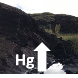
Permafrost Thaw Increases Methylmercury Formation in Subarctic Fennoscandia
2021. Brittany Tarbier (et al.). Environmental Science and Technology 55 (10), 6710-6717
ArtikelLäs mer om Permafrost Thaw Increases Methylmercury Formation in Subarctic FennoscandiaMethylmercury (MeHg) forms in anoxic environments and can bioaccumulate and biomagnify in aquatic food webs to concentrations of concern for human and wildlife health. Mercury (Hg) pollution in the Arctic environment may worsen as these areas warm and Hg, currently locked in permafrost soils, is remobilized. One of the main concerns is the development of Hg methylation hotspots in the terrestrial environment due to thermokarst formation. The extent to which net methylation of Hg is enhanced upon thaw is, however, largely unknown. Here, we have studied the formation of Hg methylation hotspots using existing thaw gradients at five Fennoscandian permafrost peatland sites. Total Hg (HgT) and MeHg concentrations were analyzed in 178 soil samples from 14 peat cores. We observed 10 times higher concentrations of MeHg and 13 times higher %MeHg in the collapse fen (representing thawed conditions) as compared to the peat plateau (representing frozen conditions). This suggests significantly greater net methylation of Hg when thermokarst wetlands are formed. In addition, we report HgT to soil organic carbon ratios representative of Fennoscandian permafrost peatlands (median and interquartile range of 0.09 +/- 0.07 mu g HgT g(-1) C) that are of value for future estimates of circumpolar HgT stocks.
-
Reconstructing Past Global Vegetation With Random Forest Machine Learning, Sacrificing the Dynamic Response for Robust Results
2021. Amelie Lindgren (et al.). Journal of Advances in Modeling Earth Systems 13 (2)
ArtikelLäs mer om Reconstructing Past Global Vegetation With Random Forest Machine Learning, Sacrificing the Dynamic Response for Robust ResultsVegetation is an important component in the Earth system, providing a direct link between the biosphere and atmosphere. As such, a representative vegetation pattern is needed to accurately simulate climate. We attempt to model global vegetation (biomes) with a data‐driven approach, to test if this allows us to create robust global and regional vegetation patterns. This not only provides quantitative reconstructions of past vegetation cover as a climate forcing, but also improves our understanding of past land cover‐climate interactions which have important implications for the future. By using a Random Forest (RF) machine learning tool, we train the vegetation reconstruction with available biomized pollen data of present and past conditions to produce broad‐scale vegetation patterns for the preindustrial (PI), the mid‐Holocene (MH, ∼6,000 years ago), and the Last Glacial Maximum (LGM, ∼21,000 years ago). We test the method's robustness by introducing a systematic temperature bias based on existing climate model spread and compare the result with that of LPJ‐GUESS, an individual‐based dynamic global vegetation model. The results show that the RF approach is able to produce robust patterns for periods and regions well constrained by evidence (the PI and the MH), but fails when evidence is scarce (the LGM). The apparent robustness of this method is achieved at the cost of sacrificing the ability to model dynamic vegetation response to a changing climate.
-
Spatial heterogeneity and environmental predictors of permafrost region soil organic carbon stocks
2021. Umakant Mishra (et al.). Science Advances 7 (9)
ArtikelLäs mer om Spatial heterogeneity and environmental predictors of permafrost region soil organic carbon stocksLarge stocks of soil organic carbon (SOC) have accumulated in the Northern Hemisphere permafrost region, but their current amounts and future fate remain uncertain. By analyzing dataset combining >2700 soil profiles with environmental variables in a geospatial framework, we generated spatially explicit estimates of permafrost-region SOC stocks, quantified spatial heterogeneity, and identified key environmental predictors. We estimated that 1014+194−175 Pg C are stored in the top 3 m of permafrost region soils. The greatest uncertainties occurred in circumpolar toe-slope positions and in flat areas of the Tibetan region. We found that soil wetness index and elevation are the dominant topographic controllers and surface air temperature (circumpolar region) and precipitation (Tibetan region) are significant climatic controllers of SOC stocks. Our results provide first high-resolution geospatial assessment of permafrost region SOC stocks and their relationships with environmental factors, which are crucial for modeling the response of permafrost affected soils to changing climate.
-
Temperature effects on carbon storage are controlled by soil stabilisation capacities
2021. Iain P. Hartley (et al.). Nature Communications 12 (1)
ArtikelLäs mer om Temperature effects on carbon storage are controlled by soil stabilisation capacitiesPhysical and chemical stabilisation mechanisms are now known to play a critical role in controlling carbon (C) storage in mineral soils, leading to suggestions that climate warming-induced C losses may be lower than previously predicted. By analysing > 9,000 soil profiles, here we show that, overall, C storage declines strongly with mean annual temperature. However, the reduction in C storage with temperature was more than three times greater in coarse-textured soils, with limited capacities for stabilising organic matter, than in fine-textured soils with greater stabilisation capacities. This pattern was observed independently in cool and warm regions, and after accounting for potentially confounding factors (plant productivity, precipitation, aridity, cation exchange capacity, and pH). The results could not, however, be represented by an established Earth system model (ESM). We conclude that warming will promote substantial soil C losses, but ESMs may not be predicting these losses accurately or which stocks are most vulnerable.
-
The Boreal-Arctic Wetland and Lake Dataset (BAWLD)
2021. David Olefeldt (et al.). Earth System Science Data 13 (11), 5127-5149
ArtikelLäs mer om The Boreal-Arctic Wetland and Lake Dataset (BAWLD)Methane emissions from boreal and arctic wetlands, lakes, and rivers are expected to increase in response to warming and associated permafrost thaw. However, the lack of appropriate land cover datasets for scaling field-measured methane emissions to circumpolar scales has contributed to a large uncertainty for our understanding of present-day and future methane emissions. Here we present the BorealArctic Wetland and Lake Dataset (BAWLD), a land cover dataset based on an expert assessment, extrapolated using random forest modelling from available spatial datasets of climate, topography, soils, permafrost conditions, vegetation, wetlands, and surface water extents and dynamics. In BAWLD, we estimate the fractional coverage of five wetland, seven lake, and three river classes within 0.5 x 0.5 degrees grid cells that cover the northern boreal and tundra biomes (17 % of the global land surface). Land cover classes were defined using criteria that ensured distinct methane emissions among classes, as indicated by a co-developed comprehensive dataset of methane flux observations. In BAWLD, wetlands occupied 3.2 x 10(6) km(2) (14 % of domain) with a 95 % confidence interval between 2.8 and 3.8 x 10(6) km(2). Bog, fen, and permafrost bog were the most abundant wetland classes, covering similar to 28 % each of the total wetland area, while the highest-methane-emitting marsh and tundra wetland classes occupied 5 % and 12 %, respectively. Lakes, defined to include all lentic open-water ecosystems regardless of size, covered 1.4 x 10(6) km(2) (6 % of domain). Low-methane-emitting large lakes (>10 km(2)) and glacial lakes jointly represented 78 % of the total lake area, while high-emitting peatland and yedoma lakes covered 18 % and 4 %, respectively. Small (<0.1 km(2)) glacial, peatland, and yedoma lakes combined covered 17 % of the total lake area but contributed disproportionally to the overall spatial uncertainty in lake area with a 95 % confidence interval between 0.15 and 0.38 x 10(6) km(2). Rivers and streams were estimated to cover 0.12 x 10(6) km(2) (0.5 % of domain), of which 8 % was associated with high-methane-emitting headwaters that drain organic-rich landscapes. Distinct combinations of spatially co-occurring wetland and lake classes were identified across the BAWLD domain, allowing for the mapping of wetscapes that have characteristic methane emission magnitudes and sensitivities to climate change at regional scales. With BAWLD, we provide a dataset which avoids double-accounting of wetland, lake, and river extents and which includes confidence intervals for each land cover class. As such, BAWLD will be suitable for many hydrological and biogeochemical modelling and upscaling efforts for the northern boreal and arctic region, in particular those aimed at improving assessments of current and future methane emissions.
-
A spatial emergent constraint on the sensitivity of soil carbon turnover to global warming
2020. Rebecca M. Varney (et al.). Nature Communications 11 (1)
ArtikelLäs mer om A spatial emergent constraint on the sensitivity of soil carbon turnover to global warmingCarbon cycle feedbacks represent large uncertainties in climate change projections, and the response of soil carbon to climate change contributes the greatest uncertainty to this. Future changes in soil carbon depend on changes in litter and root inputs from plants and especially on reductions in the turnover time of soil carbon (tau(s)) with warming. An approximation to the latter term for the top one metre of soil (Delta C-s,C-tau) can be diagnosed from projections made with the CMIP6 and CMIP5 Earth System Models (ESMs), and is found to span a large range even at 2 degrees C of global warming (-196 +/- 117 PgC). Here, we present a constraint on Delta C-s,C-tau, which makes use of current heterotrophic respiration and the spatial variability of tau(s) inferred from observations. This spatial emergent constraint allows us to halve the uncertainty in Delta C-s,C-tau at 2 degrees C to -232 +/- 52 PgC.
-
Carbon loss from northern circumpolar permafrost soils amplified by rhizosphere priming
2020. Frida Keuper (et al.). Nature Geoscience 13 (8), 560-565
ArtikelLäs mer om Carbon loss from northern circumpolar permafrost soils amplified by rhizosphere primingAs global temperatures continue to rise, a key uncertainty of climate projections is the microbial decomposition of vast organic carbon stocks in thawing permafrost soils. Decomposition rates can accelerate up to fourfold in the presence of plant roots, and this mechanism-termed the rhizosphere priming effect-may be especially relevant to thawing permafrost soils as rising temperatures also stimulate plant productivity in the Arctic. However, priming is currently not explicitly included in any model projections of future carbon losses from the permafrost area. Here, we combine high-resolution spatial and depth-resolved datasets of key plant and permafrost properties with empirical relationships of priming effects from living plants on microbial respiration. We show that rhizosphere priming amplifies overall soil respiration in permafrost-affected ecosystems by similar to 12%, which translates to a priming-induced absolute loss of similar to 40 Pg soil carbon from the northern permafrost area by 2100. Our findings highlight the need to include fine-scale ecological interactions in order to accurately predict large-scale greenhouse gas emissions, and suggest even tighter restrictions on the estimated 200 Pg anthropogenic carbon emission budget to keep global warming below 1.5 degrees C.
-
Carbon release through abrupt permafrost thaw
2020. Merritt R. Turetsky (et al.). Nature Geoscience 13 (2), 138-+
ArtikelLäs mer om Carbon release through abrupt permafrost thawThe permafrost zone is expected to be a substantial carbon source to the atmosphere, yet large-scale models currently only simulate gradual changes in seasonally thawed soil. Abrupt thaw will probably occur in <20% of the permafrost zone but could affect half of permafrost carbon through collapsing ground, rapid erosion and landslides. Here, we synthesize the best available information and develop inventory models to simulate abrupt thaw impacts on permafrost carbon balance. Emissions across 2.5 million km(2) of abrupt thaw could provide a similar climate feedback as gradual thaw emissions from the entire 18 million km(2) permafrost region under the warming projection of Representative Concentration Pathway 8.5. While models forecast that gradual thaw may lead to net ecosystem carbon uptake under projections of Representative Concentration Pathway 4.5, abrupt thaw emissions are likely to offset this potential carbon sink. Active hillslope erosional features will occupy 3% of abrupt thaw terrain by 2300 but emit one-third of abrupt thaw carbon losses. Thaw lakes and wetlands are methane hot spots but their carbon release is partially offset by slowly regrowing vegetation. After considering abrupt thaw stabilization, lake drainage and soil carbon uptake by vegetation regrowth, we conclude that models considering only gradual permafrost thaw are substantially underestimating carbon emissions from thawing permafrost.
-
Lability classification of soil organic matter in the northern permafrost region
2020. Peter Kuhry (et al.). Biogeosciences 17 (2), 361-379
ArtikelLäs mer om Lability classification of soil organic matter in the northern permafrost regionThe large stocks of soil organic carbon (SOC) in soils and deposits of the northern permafrost region are sensitive to global warming and permafrost thawing. The potential release of this carbon (C) as greenhouse gases to the atmosphere does not only depend on the total quantity of soil organic matter (SOM) affected by warming and thawing, but it also depends on its lability (i.e., the rate at which it will decay). In this study we develop a simple and robust classification scheme of SOM lability for the main types of soils and deposits in the northern permafrost region. The classification is based on widely available soil geochemical parameters and landscape unit classes, which makes it useful for upscaling to the entire northern permafrost region. We have analyzed the relationship between C content and C-CO2 production rates of soil samples in two different types of laboratory incubation experiments. In one experiment, ca. 240 soil samples from four study areas were incubated using the same protocol (at 5 degrees C, aerobically) over a period of 1 year. Here we present C release rates measured on day 343 of incubation. These long-term results are compared to those obtained from short-term incubations of ca. 1000 samples (at 12 degrees C, aerobically) from an additional three study areas. In these experiments, C-CO2 production rates were measured over the first 4 d of incubation. We have focused our analyses on the relationship between C-CO2 production per gram dry weight per day (mu gC-CO2 gdw(-1) d(-1)) and C content (%C of dry weight) in the samples, but we show that relationships are consistent when using C = N ratios or different production units such as mu gC per gram soil C per day (mu gC-CO2 gC(-1) d(-1)) or per cm(3) of soil per day (mu gC-CO2 cm(-3) d(-1)). C content of the samples is positively correlated to C-CO2 production rates but explains less than 50% of the observed variability when the full datasets are considered. A partitioning of the data into landscape units greatly reduces variance and provides consistent results between incubation experiments. These results indicate that relative SOM lability decreases in the order of Late Holocene eolian deposits to alluvial deposits and mineral soils (including peaty wetlands) to Pleistocene yedoma deposits to C-enriched pockets in cryoturbated soils to peat deposits. Thus, three of the most important SOC storage classes in the northern permafrost region (yedoma, cryoturbated soils and peatlands) show low relative SOM lability. Previous research has suggested that SOM in these pools is relatively undecomposed, and the reasons for the observed low rates of decomposition in our experiments need urgent attention if we want to better constrain the magnitude of the thawing permafrost carbon feedback on global warming.
-
Large stocks of peatland carbon and nitrogen are vulnerable to permafrost thaw
2020. Gustaf Hugelius (et al.). Proceedings of the National Academy of Sciences of the United States of America 117 (34), 20438-20446
ArtikelLäs mer om Large stocks of peatland carbon and nitrogen are vulnerable to permafrost thawNorthern peatlands have accumulated large stocks of organic carbon (C) and nitrogen (N), but their spatial distribution and vulnerability to climate warming remain uncertain. Here, we used machine-learning techniques with extensive peat core data (n > 7,000) to create observation-based maps of northern peatland C and N stocks, and to assess their response to warming and permafrost thaw. We estimate that northern peatlands cover 3.7 ± 0.5 million km2 and store 415 ± 150 Pg C and 10 ± 7 Pg N. Nearly half of the peatland area and peat C stocks are permafrost affected. Using modeled global warming stabilization scenarios (from 1.5 to 6 °C warming), we project that the current sink of atmospheric C (0.10 ± 0.02 Pg C⋅y−1) in northern peatlands will shift to a C source as 0.8 to 1.9 million km2 of permafrost-affected peatlands thaw. The projected thaw would cause peatland greenhouse gas emissions equal to ∼1% of anthropogenic radiative forcing in this century. The main forcing is from methane emissions (0.7 to 3 Pg cumulative CH4-C) with smaller carbon dioxide forcing (1 to 2 Pg CO2-C) and minor nitrous oxide losses. We project that initial CO2-C losses reverse after ∼200 y, as warming strengthens peatland C-sinks. We project substantial, but highly uncertain, additional losses of peat into fluvial systems of 10 to 30 Pg C and 0.4 to 0.9 Pg N. The combined gaseous and fluvial peatland C loss estimated here adds 30 to 50% onto previous estimates of permafrost-thaw C losses, with southern permafrost regions being the most vulnerable.
-
Modeled Microbial Dynamics Explain the Apparent Temperature Sensitivity of Wetland Methane Emissions
2020. Sarah E. Chadburn (et al.). Global Biogeochemical Cycles 34 (11)
ArtikelLäs mer om Modeled Microbial Dynamics Explain the Apparent Temperature Sensitivity of Wetland Methane EmissionsMethane emissions from natural wetlands tend to increase with temperature and therefore may lead to a positive feedback under future climate change. However, their temperature response includes confounding factors and appears to differ on different time scales. Observed methane emissions depend strongly on temperature on a seasonal basis, but if the annual mean emissions are compared between sites, there is only a small temperature effect. We hypothesize that microbial dynamics are a major driver of the seasonal cycle and that they can explain this apparent discrepancy. We introduce a relatively simple model of methanogenic growth and dormancy into a wetland methane scheme that is used in an Earth system model. We show that this addition is sufficient to reproduce the observed seasonal dynamics of methane emissions in fully saturated wetland sites, at the same time as reproducing the annual mean emissions. We find that a more complex scheme used in recent Earth system models does not add predictive power. The sites used span a range of climatic conditions, with the majority in high latitudes. The difference in apparent temperature sensitivity seasonally versus spatially cannot be recreated by the non-microbial schemes tested. We therefore conclude that microbial dynamics are a strong candidate to be driving the seasonal cycle of wetland methane emissions. We quantify longer-term temperature sensitivity using this scheme and show that it gives approximately a 12% increase in emissions per degree of warming globally. This is in addition to any hydrological changes, which could also impact future methane emissions.
-
Reduced net methane emissions due to microbial methane oxidation in a warmer Arctic
2020. Youmi Oh (et al.). Nature Climate Change 10 (4), 317-321
ArtikelLäs mer om Reduced net methane emissions due to microbial methane oxidation in a warmer ArcticMethane emissions from organic-rich soils in the Arctic have been extensively studied due to their potential to increase the atmospheric methane burden as permafrost thaws(1-3). However, this methane source might have been overestimated without considering high-affinity methanotrophs (HAMs; methane-oxidizing bacteria) recently identified in Arctic mineral soils(4-7). Herein we find that integrating the dynamics of HAMs and methanogens into a biogeochemistry model(8-10) that includes permafrost soil organic carbon dynamics(3) leads to the upland methane sink doubling (similar to 5.5 Tg CH4 yr(-1)) north of 50 degrees N in simulations from 2000-2016. The increase is equivalent to at least half of the difference in net methane emissions estimated between process-based models and observation-based inversions(11,12), and the revised estimates better match site-level and regional observations(5,7,13-15). The new model projects doubled wetland methane emissions between 2017-2100 due to more accessible permafrost carbon(16-18). However, most of the increase in wetland emissions is offset by a concordant increase in the upland sink, leading to only an 18% increase in net methane emission (from 29 to 35 Tg CH4 yr(-1)). The projected net methane emissions may decrease further due to different physiological responses between HAMs and methanogens in response to increasing temperature(19,20).
-
Subsea permafrost carbon stocks and climate change sensitivity estimated by expert assessment
2020. Sayedeh Sara Sayedi (et al.). Environmental Research Letters 15 (12)
ArtikelLäs mer om Subsea permafrost carbon stocks and climate change sensitivity estimated by expert assessmentThe continental shelves of the Arctic Ocean and surrounding seas contain large stocks of organic matter (OM) and methane (CH4), representing a potential ecosystem feedback to climate change not included in international climate agreements. We performed a structured expert assessment with 25 permafrost researchers to combine quantitative estimates of the stocks and sensitivity of organic carbon in the subsea permafrost domain (i.e. unglaciated portions of the continental shelves exposed during the last glacial period). Experts estimated that the subsea permafrost domain contains similar to 560 gigatons carbon (GtC; 170-740, 90% confidence interval) in OM and 45 GtC (10-110) in CH4. Current fluxes of CH4 and carbon dioxide (CO2) to the water column were estimated at 18 (2-34) and 38 (13-110) megatons C yr(-1), respectively. Under Representative Concentration Pathway (RCP) RCP8.5, the subsea permafrost domain could release 43 Gt CO2-equivalent (CO(2)e) by 2100 (14-110) and 190 Gt CO(2)e by 2300 (45-590), with similar to 30% fewer emissions under RCP2.6. The range of uncertainty demonstrates a serious knowledge gap but provides initial estimates of the magnitude and timing of the subsea permafrost climate feedback.
-
The Global Methane Budget 2000-2017
2020. Marielle Saunois (et al.). Earth System Science Data 12 (3), 1561-1623
ArtikelLäs mer om The Global Methane Budget 2000-2017Understanding and quantifying the global methane (CH4) budget is important for assessing realistic pathways to mitigate climate change. Atmospheric emissions and concentrations of CH4 continue to increase, making CH4 the second most important human-influenced greenhouse gas in terms of climate forcing, after carbon dioxide (CO2). The relative importance of CH4 compared to CO2 depends on its shorter atmospheric lifetime, stronger warming potential, and variations in atmospheric growth rate over the past decade, the causes of which are still debated. Two major challenges in reducing uncertainties in the atmospheric growth rate arise from the variety of geographically overlapping CH4 sources and from the destruction of CH4 by short-lived hydroxyl radicals (OH). To address these challenges, we have established a consortium of multidisciplinary scientists under the umbrella of the Global Carbon Project to synthesize and stimulate new research aimed at improving and regularly updating the global methane budget. Following Saunois et al. (2016), we present here the second version of the living review paper dedicated to the decadal methane budget, integrating results of top-down studies (atmospheric observations within an atmospheric inverse-modelling framework) and bottom-up estimates (including process-based models for estimating land surface emissions and atmospheric chemistry, inventories of anthropogenic emissions, and data-driven extrapolations). For the 2008-2017 decade, global methane emissions are estimated by atmospheric inversions (a top-down approach) to be 576 Tg CH4 yr(-1) (range 550-594, corresponding to the minimum and maximum estimates of the model ensemble). Of this total, 359 Tg CH4 yr(-1) or similar to 60 % is attributed to anthropogenic sources, that is emissions caused by direct human activity (i.e. anthropogenic emissions; range 336-376 Tg CH4 yr(-1) or 50 %-65 %). The mean annual total emission for the new decade (2008-2017) is 29 Tg CH4 yr(-1) larger than our estimate for the previous decade (2000-2009), and 24 Tg CH4 yr(-1) larger than the one reported in the previous budget for 2003-2012 (Saunois et al., 2016). Since 2012, global CH4 emissions have been tracking the warmest scenarios assessed by the Intergovernmental Panel on Climate Change. Bottom-up methods suggest almost 30 % larger global emissions (737 Tg CH4 yr(-1), range 594-881) than top-down inversion methods. Indeed, bottom-up estimates for natural sources such as natural wetlands, other inland water systems, and geological sources are higher than top-down estimates. The atmospheric constraints on the top-down budget suggest that at least some of these bottom-up emissions are overestimated. The latitudinal distribution of atmospheric observation-based emissions indicates a predominance of tropical emissions (similar to 65 % of the global budget, < 30 degrees N) compared to mid-latitudes (similar to 30 %, 30-60 degrees N) and high northern latitudes (similar to 4 %, 60-90 degrees N). The most important source of uncertainty in the methane budget is attributable to natural emissions, especially those from wetlands and other inland waters. Some of our global source estimates are smaller than those in previously published budgets (Saunois et al., 2016; Kirschke et al., 2013). In particular wetland emissions are about 35 Tg CH4 yr(-1) lower due to improved partition wetlands and other inland waters. Emissions from geological sources and wild animals are also found to be smaller by 7 Tg CH4 yr(-1) by 8 Tg CH4 yr(-1), respectively. However, the overall discrepancy between bottomup and top-down estimates has been reduced by only 5 % compared to Saunois et al. (2016), due to a higher estimate of emissions from inland waters, highlighting the need for more detailed research on emissions factors. Priorities for improving the methane budget include (i) a global, high-resolution map of water-saturated soils and inundated areas emitting methane based on a robust classification of different types of emitting habitats; (ii) further development of process-based models for inland-water emissions; (iii) intensification of methane observations at local scales (e.g., FLUXNET-CH4 measurements) and urban-scale monitoring to constrain bottom-up land surface models, and at regional scales (surface networks and satellites) to constrain atmospheric inversions; (iv) improvements of transport models and the representation of photochemical sinks in top-down inversions; and (v) development of a 3D variational inversion system using isotopic and/or co-emitted species such as ethane to improve source partitioning. The data presented here can be downloaded from https://doi.org/10.18160/GCP-CH4-2019 (Saunois et al., 2020) and from the Global Carbon Project.
-
Approaching the potential of model-data comparisons of global land carbon storage
2019. Zhendong Wu (et al.). Scientific Reports 9
ArtikelLäs mer om Approaching the potential of model-data comparisons of global land carbon storageCarbon storage dynamics in vegetation and soil are determined by the balance of carbon influx and turnover. Estimates of these opposing fluxes differ markedly among different empirical datasets and models leading to uncertainty and divergent trends. To trace the origin of such discrepancies through time and across major biomes and climatic regions, we used a model-data fusion framework. The framework emulates carbon cycling and its component processes in a global dynamic ecosystem model, LPJ-GUESS, and preserves the model-simulated pools and fluxes in space and time. Thus, it allows us to replace simulated carbon influx and turnover with estimates derived from empirical data, bringing together the strength of the model in representing processes, with the richness of observational data informing the estimations. The resulting vegetation and soil carbon storage and global land carbon fluxes were compared to independent empirical datasets. Results show model-data agreement comparable to, or even better than, the agreement between independent empirical datasets. This suggests that only marginal improvement in land carbon cycle simulations can be gained from comparisons of models with current-generation datasets on vegetation and soil carbon. Consequently, we recommend that model skill should be assessed relative to reference data uncertainty in future model evaluation studies.
-
Controls of soil organic matter on soil thermal dynamics in the northern high latitudes
2019. Dan Zhu (et al.). Nature Communications 10
ArtikelLäs mer om Controls of soil organic matter on soil thermal dynamics in the northern high latitudesPermafrost warming and potential soil carbon (SOC) release after thawing may amplify climate change, yet model estimates of present-day and future permafrost extent vary widely, partly due to uncertainties in simulated soil temperature. Here, we derive thermal diffusivity, a key parameter in the soil thermal regime, from depth-specific measurements of monthly soil temperature at about 200 sites in the high latitude regions. We find that, among the tested soil properties including SOC, soil texture, bulk density, and soil moisture, SOC is the dominant factor controlling the variability of diffusivity among sites. Analysis of the CMIP5 model outputs reveals that the parameterization of thermal diffusivity drives the differences in simulated present-day permafrost extent among these models. The strong SOC-thermics coupling is crucial for projecting future permafrost dynamics, since the response of soil temperature and permafrost area to a rising air temperature would be impacted by potential changes in SOC.
-
Distribution of carbon and nitrogen along hillslopes in three valleys on Herschel Island, Yukon Territory, Canada
2019. Justine L. Ramage (et al.). Catena (Cremlingen. Print) 178, 132-140
ArtikelLäs mer om Distribution of carbon and nitrogen along hillslopes in three valleys on Herschel Island, Yukon Territory, CanadaThermokarst results from the thawing of ice-rich permafrost and alters the biogeochemical cycling in the Arctic by reworking soil material and redistributing soil organic carbon (SOC) and total nitrogen (TN) along uplands, hillslopes, and lowlands. Understanding the impact of this redistribution is key to better estimating the storage of SOC in permafrost terrains. However, there are insufficient studies quantifying long-term impacts of thaw processes on the distribution of SOC and TN along hillslopes. We address this issue by providing estimates of SOC and TN stocks along the hillslopes of three valleys located on Herschel Island (Yukon, Canada), and by discussing the impact of hillslope thermokarst on the variability of SOC and TN stocks. We found that the average SOC and TN 0-100 cm stocks in the valleys were 26.4 +/- 8.9 kg C m(-2) and 2.1 +/- 0.6 kg N m(-2). We highlight the strong variability in the soils physical and geochemical properties within hillslope positions. High SOC stocks were found at the summits, essentially due to burial of organic matter by cryoturbation, and at the toeslopes due to impeded drainage which favored peat formation and SOC accumulation. The average carbon-to-nitrogen ratio in the valleys was 12.9, ranging from 9.7 to 18.9, and was significantly higher at the summits compared to the backslopes and footslopes (p < 0.05), suggesting a degradation of SOC downhill. Carbon and nitrogen contents and stocks were significantly lower on 16% of the sites that were previously affected by hillslope thermokarst (p < 0.05). Our results showed that lateral redistribution of SOC and TN due to hillslope thermokarst has a strong impact on the SOC storage in ice-rich permafrost terrains.
-
Evaluation of terrestrial pan-Arctic carbon cycling using a data-assimilation system
2019. Efrén López-Blanco (et al.). Earth System Dynamics 10 (2), 233-255
ArtikelLäs mer om Evaluation of terrestrial pan-Arctic carbon cycling using a data-assimilation systemThere is a significant knowledge gap in the current state of the terrestrial carbon (C) budget. Recent studies have highlighted a poor understanding particularly of C pool transit times and of whether productivity or biomass dominate these biases. The Arctic, accounting for approximately 50 % of the global soil organic C stocks, has an important role in the global C cycle. Here, we use the CARbon DAta MOdel (CARDAMOM) data-assimilation system to produce pan-Arctic terrestrial C cycle analyses for 2000-2015. This approach avoids using traditional plant functional type or steady-state assumptions. We integrate a range of data (soil organic C, leaf area index, biomass, and climate) to determine the most likely state of the high-latitude C cycle at a 1 degrees x 1 degrees resolution and also to provide general guidance about the controlling biases in transit times. On average, CARDAMOM estimates regional mean rates of photosynthesis of 565 g C m(-2) yr (-1) (90 % confidence interval between the 5th and 95th percentiles: 428, 741), autotrophic respiration of 270 g Cm-2 yr(-1) (182, 397) and heterotrophic respiration of 219 g Cm-2 yr(-1) (31, 1458), suggesting a pan-Arctic sink of -67 (-287, 1160) g Cm-2 yr(-1), weaker in tundra and stronger in taiga. However, our confidence intervals remain large (and so the region could be a source of C), reflecting uncertainty assigned to the regional data products. We show a clear spatial and temporal agreement between CARDAMOM analyses and different sources of assimilated and independent data at both pan-Arctic and local scales but also identify consistent biases between CARDAMOM and validation data. The assimilation process requires clearer error quantification for leaf area index (LAI) and biomass products to resolve these biases. Mapping of vegetation C stocks and change over time and soil C ages linked to soil C stocks is required for better analytical constraint. Comparing CARDAMOM analyses to global vegetation models (GVMs) for the same period, we conclude that transit times of vegetation C are inconsistently simulated in GVMs due to a combination of uncertainties from productivity and biomass calculations. Our findings highlight that GVMs need to focus on constraining both current vegetation C stocks and net primary production to improve a process-based understanding of C cycle dynamics in the Arctic.
-
FLUXNET-CH4 Synthesis Activity: Objectives, Observations, and Future Directions
2019. Sara H. Knox (et al.). Bulletin of The American Meteorological Society - (BAMS) 100 (12), 2607-2632
ArtikelLäs mer om FLUXNET-CH4 Synthesis ActivityThis paper describes the formation of, and initial results for, a new FLUXNET coordination network for ecosystem-scale methane (CH4) measurements at 60 sites globally, organized by the Global Carbon Project in partnership with other initiatives and regional flux tower networks. The objectives of the effort are presented along with an overview of the coverage of eddy covariance (EC) CH4 flux measurements globally, initial results comparing CH4 fluxes across the sites, and future research directions and needs. Annual estimates of net CH4 fluxes across sites ranged from -0.2 +/- 0.02 g C m(-2) yr(-1) for an upland forest site to 114.9 +/- 13.4 g C m(-2) yr(-1) for an estuarine freshwater marsh, with fluxes exceeding 40 g C m(-2) yr(-1) at multiple sites. Average annual soil and air temperatures were found to be the strongest predictor of annual CH4 flux across wetland sites globally. Water table position was positively correlated with annual CH4 emissions, although only for wetland sites that were not consistently inundated throughout the year. The ratio of annual CH4 fluxes to ecosystem respiration increased significantly with mean site temperature. Uncertainties in annual CH4 estimates due to gap-filling and random errors were on average +/- 1.6 g C m(-2) yr(-1) at 95% confidence, with the relative error decreasing exponentially with increasing flux magnitude across sites. Through the analysis and synthesis of a growing EC CH4 flux database, the controls on ecosystem CH4 fluxes can be better understood, used to inform and validate Earth system models, and reconcile differences between land surface model- and atmospheric-based estimates of CH4 emissions.
-
Land cover and landform-based upscaling of soil organic carbon stocks on the Brogger Peninsula, Svalbard
2019. Robin Wojcik (et al.). Arctic, Antarctic and Alpine research 51 (1), 40-57
ArtikelLäs mer om Land cover and landform-based upscaling of soil organic carbon stocks on the Brogger Peninsula, SvalbardIn this study we assess the total storage, landscape distribution, and vertical partitioning of soil organic carbon (SOC) stocks on the Brogger Peninsula, Svalbard. This type of high Arctic area is underrepresented in SOC databases for the northern permafrost region. Physico-chemical, elemental, and radiocarbon (C-14) dating analyses were carried out on thirty-two soil profiles. Results were upscaled using both a land cover classification (LCC) and a landform classification (LFC). Both LCC and LFC approaches provide weighted mean SOC 0-100 cm estimates for the study area of 1.0 +/- 0.3 kg C m(-2) (95% confidence interval) and indicate that about 68 percent of the total SOC storage occurs in the upper 30 cm of the soil, and about 10 percent occurs in the surface organic layer. Furthermore, LCC and LFC upscaling approaches provide similar spatial SOC allocation estimates and emphasize the dominant role of vegetated area (4.2 +/- 1.6 kg C m(-2)) and solifluction slopes (6.7 +/- 3.6 kg C m(-2)) in SOC 0-100 cm storage. LCC and LFC approaches report different and complementary information on the dominant processes controlling the spatial and vertical distribution of SOC in the landscape. There is no evidence for any significant SOC storage in the permafrost layer. We hypothesize, therefore, that the Brogger Peninsula and similar areas of the high Arctic will become net carbon sinks, providing negative feedback on global warming in the future. The surface area that will have vegetation cover and incipient soil development will expand, whereas only small amounts of organic matter will experience increased decomposition due to active-layer deepening.
-
Mojito, Anyone? An Exploration of Low-Tech Plant Water Extraction Methods for Isotopic Analysis Using Locally-Sourced Materials
2019. Benjamin M. C. Fischer (et al.). Frontiers in Earth Science 7
ArtikelLäs mer om Mojito, Anyone? An Exploration of Low-Tech Plant Water Extraction Methods for Isotopic Analysis Using Locally-Sourced MaterialsThe stable isotope composition of water (delta O-18 and delta H-2) is an increasingly utilized tool to distinguish between different pools of water along the soil-plant-atmosphere continuum (SPAC) and thus provides information on how plants use water. Clear bottlenecks for the ubiquitous application of isotopic analysis across the SPAC are the relatively high-energy and specialized materials required to extract water from plant materials. Could simple and cost-effective do-it-yourself MacGyver methods be sufficient for extracting plant water for isotopic analysis? This study develops a suite of novel techniques for plant water extraction and compares them to a standard research-grade water extraction method. Our results show that low-tech methods using locally-sourced materials can indeed extract plant water consistently and comparably to what is done with other state-of-the-art methods. Further, our findings show that other factors play a larger role than water extraction methods in achieving the desired accuracy and precision of stable isotope composition: (1) appropriate transport, (2) fast sample processing and (3) efficient workflows. These results are methodologically promising for the rapid expansion of isotopic investigations, especially for citizen science and/or school projects or in remote areas, where improved SPAC understanding could help manage water resources to fulfill agricultural and other competing water needs.
-
Rivers across the Siberian Arctic unearth the patterns of carbon release from thawing permafrost
2019. Birgit Wild (et al.). Proceedings of the National Academy of Sciences of the United States of America 116 (21), 10280-10285
ArtikelLäs mer om Rivers across the Siberian Arctic unearth the patterns of carbon release from thawing permafrostClimate warming is expected to mobilize northern permafrost and peat organic carbon (PP-C), yet magnitudes and system specifics of even current releases are poorly constrained. While part of the PP-C will degrade at point of thaw to CO2 and CH4 to directly amplify global warming, another part will enter the fluvial network, potentially providing a window to observe large-scale PP-C remobilization patterns. Here, we employ a decade-long, high-temporal resolution record of C-14 in dissolved and particulate organic carbon (DOC and POC, respectively) to deconvolute PP-C release in the large drainage basins of rivers across Siberia: Ob, Yenisey, Lena, and Kolyma. The C-14-constrained estimate of export specifically from PP-C corresponds to only 17 +/- 8% of total fluvial organic carbon and serves as a benchmark for monitoring changes to fluvial PP-C remobilization in a warming Arctic. Whereas DOC was dominated by recent organic carbon and poorly traced PP-C (12 +/- 8%), POC carried a much stronger signature of PP-C (63 +/- 10%) and represents the best window to detect spatial and temporal dynamics of PP-C release. Distinct seasonal patterns suggest that while DOC primarily stems from gradual leaching of surface soils, POC reflects abrupt collapse of deeper deposits. Higher dissolved PP-C export by Ob and Yenisey aligns with discontinuous permafrost that facilitates leaching, whereas higher particulate PP-C export by Lena and Kolyma likely echoes the thermokarst-induced collapse of Pleistocene deposits. Quantitative C-14-based fingerprinting of fluvial organic carbon thus provides an opportunity to elucidate large-scale dynamics of PP-C remobilization in response to Arctic warming.
-
The landscape of soil carbon data: emerging questions, synergies and databases
2019. Avni Malhotra (et al.). Progress in physical geography 43 (5), 707-719
ArtikelLäs mer om The landscape of soil carbon dataSoil carbon has been measured for over a century in applications ranging from understanding biogeochemical processes in natural ecosystems to quantifying the productivity and health of managed systems. Consolidating diverse soil carbon datasets is increasingly important to maximize their value, particularly with growing anthropogenic and climate change pressures. In this progress report, we describe recent advances in soil carbon data led by the International Soil Carbon Network and other networks. We highlight priority areas of research requiring soil carbon data, including (a) quantifying boreal, arctic and wetland carbon stocks, (b) understanding the timescales of soil carbon persistence using radiocarbon and chronosequence studies, (c) synthesizing long-term and experimental data to inform carbon stock vulnerability to global change, (d) quantifying root influences on soil carbon and (e) identifying gaps in model-data integration. We also describe the landscape of soil datasets currently available, highlighting their strengths, weaknesses and synergies. Now more than ever, integrated soil data are needed to inform climate mitigation, land management and agricultural practices. This report will aid new data users in navigating various soil databases and encourage scientists to make their measurements publicly available and to join forces to find soil-related solutions.
-
A plant-microbe interaction framework explaining nutrient effects on primary production
2018. P. T. Capek (et al.). Nature Ecology & Evolution 2 (10), 1588-1596
ArtikelLäs mer om A plant-microbe interaction framework explaining nutrient effects on primary productionIn most terrestrial ecosystems, plant growth is limited by nitrogen and phosphorus. Adding either nutrient to soil usually affects primary production, but their effects can be positive or negative. Here we provide a general stoichiometric framework for interpreting these contrasting effects. First, we identify nitrogen and phosphorus limitations on plants and soil microorganisms using their respective nitrogen to phosphorus critical ratios. Second, we use these ratios to show how soil microorganisms mediate the response of primary production to limiting and non-limiting nutrient addition along a wide gradient of soil nutrient availability. Using a meta-analysis of 51 factorial nitrogen-phosphorus fertilization experiments conducted across multiple ecosystems, we demonstrate that the response of primary production to nitrogen and phosphorus additions is accurately predicted by our stoichiometric framework. The only pattern that could not be predicted by our original framework suggests that nitrogen has not only a structural function in growing organisms, but also a key role in promoting plant and microbial nutrient acquisition. We conclude that this stoichiometric framework offers the most parsimonious way to interpret contrasting and, until now, unresolved responses of primary production to nutrient addition in terrestrial ecosystems.
-
Amino acid production exceeds plant nitrogen demand in Siberian tundra
2018. Birgit Wild (et al.). Environmental Research Letters 13 (3)
ArtikelLäs mer om Amino acid production exceeds plant nitrogen demand in Siberian tundraArctic plant productivity is often limited by low soil N availability. This has been attributed to slow breakdown of N-containing polymers in litter and soil organic matter (SOM) into smaller, available units, and to shallow plant rooting constrained by permafrost and high soil moisture. Using N-15 pool dilution assays, we here quantified gross amino acid and ammonium production rates in 97 active layer samples from four sites across the Siberian Arctic. We found that amino acid production in organic layers alone exceeded literature-based estimates of maximum plant N uptake 17-fold and therefore reject the hypothesis that arctic plant N limitation results from slow SOM breakdown. High microbial N use efficiency in organic layers rather suggests strong competition of microorganisms and plants in the dominant rooting zone. Deeper horizons showed lower amino acid production rates per volume, but also lower microbial N use efficiency. Permafrost thaw together with soil drainage might facilitate deeper plant rooting and uptake of previously inaccessible subsoil N, and thereby promote plant productivity in arctic ecosystems. We conclude that changes in microbial decomposer activity, microbial N utilization and plant root density with soil depth interactively control N availability for plants in the Arctic.
-
Extensive loss of past permafrost carbon but a net accumulation into present-day soils
2018. Amelie Lindgren, Gustaf Hugelius, Peter Kuhry. Nature 560 (7717), 219-222
ArtikelLäs mer om Extensive loss of past permafrost carbon but a net accumulation into present-day soilsAtmospheric concentrations of carbon dioxide increased between the Last Glacial Maximum (LGM, around 21,000 years ago) and the preindustrial era(1). It is thought that the evolution of this atmospheric carbon dioxide (and that of atmospheric methane) during the glacial-to-interglacial transition was influenced by organic carbon that was stored in permafrost during the LGM and then underwent decomposition and release following thaw(2,3). It has also been suggested that the rather erratic atmospheric delta C-13 and Delta C-14 signals seen during deglaciation(1.4) could partly be explained by the presence of a large terrestrial inert LGM carbon stock, despite the biosphere being less productive (and therefore storing less carbon)(5,6). Here we present an empirically derived estimate of the carbon stored in permafrost during the LGM by reconstructing the extent and carbon content of LGM biomes, peatland regions and deep sedimentary deposits. We find that the total estimated soil carbon stock for the LGM northern permafrost region is smaller than the estimated present-day storage (in both permafrost and non-permafrost soils) for the same region. A substantial decrease in the permafrost area from the LGM to the present day has been accompanied by a roughly 400-petagram increase in the total soil carbon stock. This increase in soil carbon suggests that permafrost carbon has made no net contribution to the atmospheric carbon pool since the LGM. However, our results also indicate potential postglacial reductions in the portion of the carbon stock that is trapped in permafrost, of around 1,000 petagrams, supporting earlier studies(7). We further find that carbon has shifted from being primarily stored in permafrost mineral soils and loess deposits during the LGM, to being roughly equally divided between peatlands, mineral soils and permafrost loess deposits today.
-
Landform partitioning and estimates of deep storage of soil organic matter in Zackenberg, Greenland
2018. Juri Palmtag (et al.). The Cryosphere 12 (5), 1735-1744
ArtikelLäs mer om Landform partitioning and estimates of deep storage of soil organic matter in Zackenberg, GreenlandSoils in the northern high latitudes are a key component in the global carbon cycle, with potential feedback on climate. This study aims to improve the previous soil organic carbon (SOC) and total nitrogen (TN) storage estimates for the Zackenberg area (NE Greenland) that were based on a land cover classification (LCC) approach, by using geomorphological upscaling. In addition, novel organic carbon (OC) estimates for deeper alluvial and deltaic deposits (down to 300 cm depth) are presented. We hypothesise that land-forms will better represent the long-term slope and depositional processes that result in deep SOC burial in this type of mountain permafrost environments. The updated mean SOC storage for the 0-100 cm soil depth is 4.8 kg Cm-2, which is 42% lower than the previous estimate of 8.3 kg Cm-2 based on land cover upscaling. Similarly, the mean soil TN storage in the 0-100 cm depth decreased with 44% from 0.50 kg (+/- 0.1 CI) to 0.28 (+/- 0.1 CI) kg TN m(-2). We ascribe the differences to a previous areal overestimate of SOC- and TN-rich vegetated land cover classes. The landform-based approach more correctly constrains the depositional areas in alluvial fans and deltas with high SOC and TN storage. These are also areas of deep carbon storage with an additional 2.4 kg Cm-2 in the 100-300 cm depth interval. This research emphasises the need to consider geomorphology when assessing SOC pools in mountain permafrost landscapes.
-
Long-term deglacial permafrost carbon dynamics in MPI-ESM
2018. Thomas Schneider von Deimling (et al.). Climate of the Past 14 (12), 2011-2036
ArtikelLäs mer om Long-term deglacial permafrost carbon dynamics in MPI-ESMWe have developed a new module to calculate soil organic carbon (SOC) accumulation in perennially frozen ground in the land surface model JSBACH. Running this offline version of MPI-ESM we have modelled long-term permafrost carbon accumulation and release from the Last Glacial Maximum (LGM) to the pre-industrial (PI) age. Our simulated near-surface PI permafrost extent of 16.9 x 10(6) km(2) is close to observational estimates. Glacial boundary conditions, especially ice sheet coverage, result in profoundly different spatial patterns of glacial permafrost extent. Deglacial warming leads to large-scale changes in soil temperatures, manifested in permafrost disappearance in southerly regions, and permafrost aggregation in formerly glaciated grid cells. In contrast to the large spatial shift in simulated permafrost occurrence, we infer an only moderate increase in total LGM permafrost area (18.3 x 10(6) km(2)) - together with pronounced changes in the depth of seasonal thaw. Earlier empirical reconstructions suggest a larger spread of permafrost towards more southerly regions under glacial conditions, but with a highly uncertain extent of non-continuous permafrost. Compared to a control simulation without describing the transport of SOC into perennially frozen ground, the implementation of our newly developed module for simulating permafrost SOC accumulation leads to a doubling of simulated LGM permafrost SOC storage (amounting to a total of similar to 150 PgC). Despite LGM temperatures favouring a larger permafrost extent, simulated cold glacial temperatures - together with low precipitation and low CO2 levels - limit vegetation productivity and therefore prevent a larger glacial SOC build-up in our model. Changes in physical and biogeochemical boundary conditions during deglacial warming lead to an increase in mineral SOC storage towards the Holocene (168 PgC at PI), which is below observational estimates (575 PgC in continuous and discontinuous permafrost). Additional model experiments clarified the sensitivity of simulated SOC storage to model parameters, affecting long-term soil carbon respiration rates and simulated ALDs. Rather than a steady increase in carbon release from the LGM to PI as a consequence of deglacial permafrost degradation, our results suggest alternating phases of soil carbon accumulation and loss as an effect of dynamic changes in permafrost extent, ALDs, soil litter input, and heterotrophic respiration.
-
Networking our science to characterize the state, vulnerabilities, and management opportunities of soil organic matter
2018. Jennifer W. Harden (et al.). Global Change Biology 24 (2), e705-e718
ArtikelLäs mer om Networking our science to characterize the state, vulnerabilities, and management opportunities of soil organic matterSoil organic matter (SOM) supports the Earth's ability to sustain terrestrial ecosystems, provide food and fiber, and retains the largest pool of actively cycling carbon. Over 75% of the soil organic carbon (SOC) in the top meter of soil is directly affected by human land use. Large land areas have lost SOC as a result of land use practices, yet there are compensatory opportunities to enhance productivity and SOC storage in degraded lands through improved management practices. Large areas with and without intentional management are also being subjected to rapid changes in climate, making many SOC stocks vulnerable to losses by decomposition or disturbance. In order to quantify potential SOC losses or sequestration at field, regional, and global scales, measurements for detecting changes in SOC are needed. Such measurements and soil-management best practices should be based on well established and emerging scientific understanding of processes of C stabilization and destabilization over various timescales, soil types, and spatial scales. As newly engaged members of the International Soil Carbon Network, we have identified gaps in data, modeling, and communication that underscore the need for an open, shared network to frame and guide the study of SOM and SOC and their management for sustained production and climate regulation.
-
Permafrost Stores a Globally Significant Amount of Mercury
2018. Paul F. Schuster (et al.). Geophysical Research Letters 45 (3), 1463-1471
ArtikelLäs mer om Permafrost Stores a Globally Significant Amount of MercuryChanging climate in northern regions is causing permafrost to thaw with major implications for the global mercury (Hg) cycle. We estimated Hg in permafrost regions based on in situ measurements of sediment total mercury (STHg), soil organic carbon (SOC), and the Hg to carbon ratio (R-HgC) combined with maps of soil carbon. We measured a median STHg of 43 +/- 30 ng Hg g soil(-1) and a median R-HgC of 1.6 +/- 0.9 mu g Hg g C-1, consistent with published results of STHg for tundra soils and 11,000 measurements from 4,926 temperate, nonpermafrost sites in North America and Eurasia. We estimate that the Northern Hemisphere permafrost regions contain 1,656 +/- 962 Gg Hg, of which 793 +/- 461 Gg Hg is frozen in permafrost. Permafrost soils store nearly twice as much Hg as all other soils, the ocean, and the atmosphere combined, and this Hg is vulnerable to release as permafrost thaws over the next century. Existing estimates greatly underestimate Hg in permafrost soils, indicating a need to reevaluate the role of the Arctic regions in the global Hg cycle.
-
Short and Long-Term Controls on Active Layer and Permafrost Carbon Turnover Across the Arctic
2018. Samuel Faucherre (et al.). Journal of Geophysical Research - Biogeosciences 123 (2), 372-390
ArtikelLäs mer om Short and Long-Term Controls on Active Layer and Permafrost Carbon Turnover Across the ArcticDecomposition of soil organic matter (SOM) in permafrost terrain and the production of greenhouse gases is a key factor for understanding climate change-carbon feedbacks. Previous studies have shown that SOM decomposition is mostly controlled by soil temperature, soil moisture, and carbon-nitrogen ratio (C:N). However, focus has generally been on site-specific processes and little is known about variations in the controls on SOM decomposition across Arctic sites. For assessing SOM decomposition, we retrieved 241 samples from 101 soil profiles across three contrasting Arctic regions and incubated them in the laboratory under aerobic conditions. We assessed soil carbon losses (C-loss) five times during a 1year incubation. The incubated material consisted of near-surface active layer (AL(NS)), subsurface active layer (AL(SS)), peat, and permafrost samples. Samples were analyzed for carbon, nitrogen, water content, C-13, N-15, and dry bulk density (DBD). While no significant differences were observed between total AL(SS) and permafrost C-loss over 1year incubation (2.32.4% and 2.51.5% C-loss, respectively), AL(NS) samples showed higher C-loss (7.94.2%). DBD was the best explanatory parameter for active layer C-loss across sites. Additionally, results of permafrost samples show that C:N ratio can be used to characterize initial C-loss between sites. This data set on the influence of abiotic parameter on microbial SOM decomposition can improve model simulations of Arctic soil CO2 production by providing representative mean values of CO2 production rates and identifying standard parameters or proxies for upscaling potential CO2 production from site to regional scales.
-
Significance of dark CO2 fixation in arctic soils
2018. Hana Santruckova (et al.). Soil Biology and Biochemistry 119, 11-21
ArtikelLäs mer om Significance of dark CO2 fixation in arctic soilsThe occurrence of dark fixation of CO2 by heterotrophic microorganisms in soil is generally accepted, but its importance for microbial metabolism and soil organic carbon (C) sequestration is unknown, especially under C limiting conditions. To fill this knowledge gap, we measured dark (CO2)-C-13 incorporation into soil organic matter and conducted a C-13-labelling experiment to follow the C-13 incorporation into phospholipid fatty acids as microbial biomass markers across soil profiles of four tundra ecosystems in the northern circumpolar region, where net primary productivity and thus soil C inputs are low. We further determined the abundance of various carboxylase genes and identified their microbial origin with metagenomics. The microbial capacity for heterotrophic CO2 fixation was determined by measuring the abundance of carboxylase genes and the incorporation of C-13 into soil C following the augmentation of bioavailable C sources. We demonstrate that dark CO2 fixation occurred ubiquitously in arctic tundra soils, with increasing importance in deeper soil horizons, presumably due to increasing C limitation with soil depth. Dark CO2 fixation accounted on average for 0.4, 1.0, 1.1, and 16% of net respiration in the organic, cryoturbated organic, mineral and permafrost horizons, respectively. Genes encoding anaplerotic enzymes of heterotrophic microorganisms comprised the majority of identified carboxylase genes. The genetic potential for dark CO2 fixation was spread over a broad taxonomic range. The results suggest important regulatory function of CO2 fixation in C limited conditions. The measurements were corroborated by modeling the long-term impact of dark CO2 fixation on soil organic matter. Our results suggest that increasing relative CO2 fixation rates in deeper soil horizons play an important role for soil internal C cycling and can, at least in part, explain the isotopic enrichment with soil depth.
-
Tundra landscape heterogeneity, not interannual variability, controls the decadal regional carbon balance in the Western Russian Arctic
2018. Claire C. Treat (et al.). Global Change Biology 24 (11), 5188-5204
ArtikelLäs mer om Tundra landscape heterogeneity, not interannual variability, controls the decadal regional carbon balance in the Western Russian ArcticAcross the Arctic, the net ecosystem carbon (C) balance of tundra ecosystems is highly uncertain due to substantial temporal variability of C fluxes and to landscape heterogeneity. We modeled both carbon dioxide (CO2) and methane (CH4) fluxes for the dominant land cover types in a similar to 100-km(2) sub-Arctic tundra region in northeast European Russia for the period of 2006-2015 using process-based biogeochemical models. Modeled net annual CO2 fluxes ranged from --300 g C m(-2) year(-1) [net uptake] in a willow fen to 3 g Cm-2 year(-1) [net source] in dry lichen tundra. Modeled annual CH4 emissions ranged from -0.2 to 22.3 g Cm-2 year(-1) at a peat plateau site and a willow fen site, respectively. Interannual variability over the decade was relatively small (20%-25%) in comparison with variability among the land cover types (150%). Using high-resolution land cover classification, the region was a net sink of atmospheric CO2 across most land cover types but a net source of CH4 to the atmosphere due to high emissions from permafrost-free fens. Using a lower resolution for land cover classification resulted in a 20%-65% underestimation of regional CH4 flux relative to high-resolution classification and smaller (10%) overestimation of regional CO2 uptake due to the underestimation of wetland area by 60%. The relative fraction of uplands versus wetlands was key to determining the net regional C balance at this and other Arctic tundra sites because wetlands were hot spots for C cycling in Arctic tundra ecosystems.
-
An observation-based constraint on permafrost loss as a function of global warming
2017. S. E. Chadburn (et al.). Nature Climate Change 7 (5), 340-344
ArtikelLäs mer om An observation-based constraint on permafrost loss as a function of global warmingPermafrost, which covers 15 million km(2) of the land surface, is one of the components of the Earth system that is most sensitive to warming(1,2). Loss of permafrost would radically change high-latitude hydrology and biogeochemical cycling, and could therefore provide very significant feedbacks on climate change(3-8). The latest climate models all predict warming of high-latitude soils and thus thawing of permafrost under future climate change, but with widely varying magnitudes of permafrost thaw(9,10). Here we show that in each of the models, their present-day spatial distribution of permafrost and air temperature can be used to infer the sensitivity of permafrost to future global warming. Using the same approach for the observed permafrost distribution and air temperature, we estimate a sensitivity of permafrost area loss to global mean warming at stabilization of 4.0(-1.1)(+1.0) million km(2) degrees C-1 (1 sigma confidence), which is around 20% higher than previous studies(9). Our method facilitates an assessment for COP21 climate change targets(11): if the climate is stabilized at 2 degrees C above pre-industrial levels, we estimate that the permafrost area would eventually be reduced by over 40%. Stabilizing at 1.5 degrees C rather than 2 degrees C would save approximately 2 million km(2) of permafrost.
-
Carbon stocks and fluxes in the high latitudes: using site-level data to evaluate Earth system models
2017. Sarah E. Chadburn (et al.). Biogeosciences 14 (22), 5143-5169
ArtikelLäs mer om Carbon stocks and fluxes in the high latitudesIt is important that climate models can accurately simulate the terrestrial carbon cycle in the Arctic due to the large and potentially labile carbon stocks found in permafrost-affected environments, which can lead to a positive climate feedback, along with the possibility of future carbon sinks from northward expansion of vegetation under climate warming. Here we evaluate the simulation of tundra carbon stocks and fluxes in three land surface schemes that each form part of major Earth system models (JSBACH, Germany; JULES, UK; ORCHIDEE, France). We use a site-level approach in which comprehensive, high-frequency datasets allow us to disentangle the importance of different processes. The models have improved physical permafrost processes and there is a reasonable correspondence between the simulated and measured physical variables, including soil temperature, soil moisture and snow. We show that if the models simulate the correct leaf area index (LAI), the standard C3 photosynthesis schemes produce the correct order of magnitude of carbon fluxes. Therefore, simulating the correct LAI is one of the first priorities. LAI depends quite strongly on climatic variables alone, as we see by the fact that the dynamic vegetation model can simulate most of the differences in LAI between sites, based almost entirely on climate inputs. However, we also identify an influence from nutrient limitation as the LAI becomes too large at some of the more nutrient-limited sites. We conclude that including moss as well as vascular plants is of primary importance to the carbon budget, as moss contributes a large fraction to the seasonal CO2 flux in nutrient-limited conditions. Moss photosynthetic activity can be strongly influenced by the moisture content of moss, and the carbon uptake can be significantly different from vascular plants with a similar LAI. The soil carbon stocks depend strongly on the rate of input of carbon from the vegetation to the soil, and our analysis suggests that an improved simulation of photosynthesis would also lead to an improved simulation of soil carbon stocks. However, the stocks are also influenced by soil carbon burial (e.g. through cryoturbation) and the rate of heterotrophic respiration, which depends on the soil physical state. More detailed below-ground measurements are needed to fully evaluate biological and physical soil processes. Furthermore, even if these processes are well modelled, the soil carbon profiles cannot resemble peat layers as peat accumulation processes are not represented in the models. Thus, we identify three priority areas for model development: (1) dynamic vegetation including (a) climate and (b) nutrient limitation effects; (2) adding moss as a plant functional type; and an (3) improved vertical profile of soil carbon including peat processes.
-
Decadal soil carbon accumulation across Tibetan permafrost regions
2017. Jinzhi Ding (et al.). Nature Geoscience 10 (6), 420-424
ArtikelLäs mer om Decadal soil carbon accumulation across Tibetan permafrost regionsPermafrost soils store large amounts of carbon. Warming can result in carbon release from thawing permafrost, but it can also lead to enhanced primary production, which can increase soil carbon stocks. The balance of these fluxes determines the nature of the permafrost feedback to warming. Here we assessed decadal changes in soil organic carbon stocks in the active layer-the uppermost 30 cm-of permafrost soils across Tibetan alpine regions, based on repeated soil carbon measurements in the early 2000s and 2010s at the same sites. We observed an overall accumulation of soil organic carbon irrespective of vegetation type, with a mean rate of 28.0 g Cm-2 yr(-1) across Tibetan permafrost regions. This soil organic carbon accrual occurred only in the subsurface soil, between depths of 10 and 30 cm, mainly induced by an increase of soil organic carbon concentrations. We conclude that the upper active layer of Tibetan alpine permafrost currently represents a substantial regional soil carbon sink in a warming climate, implying that carbon losses of deeper and older permafrost carbon might be offset by increases in upper-active-layer soil organic carbon stocks, which probably results from enhanced vegetation growth.
-
Deep Yedoma permafrost: A synthesis of depositional characteristics and carbon vulnerability
2017. Jens Strauss (et al.). Earth-Science Reviews 172, 75-86
ArtikelLäs mer om Deep Yedoma permafrostPermafrost is a distinct feature of the terrestrial Arctic and is vulnerable to climate warming. Permafrost degrades in different ways, including deepening of a seasonally unfrozen surface and localized but rapid development of deep thaw features. Pleistocene ice-rich permafrost with syngenetic ice-wedges, termed Yedoma deposits, are widespread in Siberia, Alaska, and Yukon, Canada and may be especially prone to rapid-thaw processes. Freeze-locked organic matter in such deposits can be re-mobilized on short time-scales and contribute to a carbon-cycle climate feedback. Here we synthesize the characteristics and vulnerability of Yedoma deposits by synthesizing studies on the Yedoma origin and the associated organic carbon pool. We suggest that Yedoma deposits accumulated under periglacial weathering, transport, and deposition dynamics in non-glaciated regions during the late Pleistocene until the beginning of late glacial warming. The deposits formed due to a combination of aeolian, colluvial, nival, and alluvial deposition and simultaneous ground ice accumulation. We found up to 130 gigatons organic carbon in Yedoma, parts of which are well-preserved and available for fast decomposition after thaw. Based on incubation experiments, up to 10% of the Yedoma carbon is considered especially decomposable and may be released upon thaw. The substantial amount of ground ice in Yedoma makes it highly vulnerable to disturbances such as thermokarst and thermo-erosion processes. Mobilization of permafrost carbon is expected to increase under future climate warming. Our synthesis results underline the need of accounting for Yedoma carbon stocks in next generation Earth-System-Models for a more complete representation of the permafrost-carbon feedback.
-
Distinguishing between old and modern permafrost sources in the northeast Siberian land-shelf system with compound-specific delta H-2 analysis
2017. Jorien E. Vonk (et al.). The Cryosphere 11 (4), 1879-1895
ArtikelLäs mer om Distinguishing between old and modern permafrost sources in the northeast Siberian land-shelf system with compound-specific delta H-2 analysisPleistocene ice complex permafrost deposits contain roughly a quarter of the organic carbon (OC) stored in permafrost (PF) terrain. When permafrost thaws, its OC is remobilized into the (aquatic) environment where it is available for degradation, transport or burial. Aquatic or coastal environments contain sedimentary reservoirs that can serve as archives of past climatic change. As permafrost thaw is increasing throughout the Arctic, these reservoirs are important locations to assess the fate of remobilized permafrost OC. We here present compound-specific deuterium (delta H-2) analysis on leaf waxes as a tool to distinguish between OC released from thawing Pleistocene permafrost (ice complex deposits; ICD) and from thawing Holocene permafrost (from near-surface soils). Bulk geochemistry (%OC; delta C-13; % total nitrogen, TN) was analyzed as well as the concentrations and delta H-2 signatures of long-chain n-alkanes (C-21 to C-33) and midto long-chain n-alkanoic acids (C-16 to C-30) extracted from both ICD-PF samples (n = 9) and modern vegetation and Ohorizon (topsoil-PF) samples (n = 9) from across the northeast Siberian Arctic. Results show that these topsoil-PF samples have higher %OC, higher OC/TN values and more depleted delta(COC)-C-13 values than ICD-PF samples, suggesting that these former samples trace a fresher soil and/or vegetation source. Whereas the two investigated sources differ on the bulk geochemical level, they are, however, virtually indistinguishable when using leaf wax concentrations and ratios. However, on the molecular isotope level, leaf wax biomarker delta H-2 values are statistically different between topsoil PF and ICD PF. For example, the mean delta H-2 value of C-29 n-alkane was -246 +/- 13% (mean +/- SD) for topsoil PF and -280 +/- 12 parts per thousand for ICD PF. With a dynamic isotopic range (difference between two sources) of 34 to 50 parts per thousand; the isotopic fingerprints of individual, abundant, biomarker molecules from leaf waxes can thus serve as endmembers to distinguish between these two sources. We tested this molecular delta H-2 tracer along with another source-distinguishing approach, dual-carbon (delta C-13-Delta C-14) isotope composition of bulk OC, for a surface sediment transect in the Laptev Sea. Results show that general offshore patterns along the shelfslope transect are similar, but the source apportionment between the approaches vary, which may highlight the advan-tages of either. This study indicates that the application of delta H-2 leaf wax values has potential to serve as a complementary quantitative measure of the source and differential fate of OC thawed out from different permafrost compartments.
-
Higher climatological temperature sensitivity of soil carbon in cold than warm climates
2017. Charles D. Koven (et al.). Nature Climate Change 7 (11), 817-822
ArtikelLäs mer om Higher climatological temperature sensitivity of soil carbon in cold than warm climatesThe projected loss of soil carbon to the atmosphere resulting from climate change is a potentially large but highly uncertain feedback to warming. The magnitude of this feedback is poorly constrained by observations and theory, and is disparately represented in Earth system models (ESMs)(1-3). To assess the climatological temperature sensitivity of soil carbon, we calculate apparent soil carbon turnover times(4) that reflect long-term and broad-scale rates of decomposition. Here, we show that the climatological temperature control on carbon turnover in the top metre of global soils is more sensitive in cold climates than in warm climates and argue that it is critical to capture this emergent ecosystem property in global-scale models. We present a simplified model that explains the observed high cold-climate sensitivity using only the physical scaling of soil freeze-thaw state across climate gradients. Current ESMs fail to capture this pattern, except in anESMthat explicitly resolves vertical gradients in soil climate and carbon turnover. An observed weak tropical temperature sensitivity emerges in a different model that explicitly resolves mineralogical control on decomposition. These results support projections of strong carbon- climate feedbacks from northern soils(5,6) and demonstrate a method for ESMs to capture this emergent behaviour.
-
Insights and issues with estimating northern peatland carbon stocks and fluxes since the Last Glacial Maximum
2017. Julie Loisel (et al.). Earth-Science Reviews 165, 59-80
ArtikelLäs mer om Insights and issues with estimating northern peatland carbon stocks and fluxes since the Last Glacial MaximumIn this review paper, we identify and address key uncertainties related to four local and global controls of Holocene northern peatland carbon stocks and fluxes. First, we provide up-to-date estimates of the current northern peatland area (3.2 M km(2)) and propose a novel approach to reconstruct changes in the northern peatland area over time (Section 2). Second, we review the key methods and models that have been used to quantify total carbon stocks and methane emissions over time at the hemispheric scale, and offer new research directions to improve these calculations (Section 3). Our main proposed improvement relates to allocating different carbon stock and emission values for each of the two dominant vegetation assemblages (sedge and brown moss-dominated vs. Sphagnum-dominated peat). Third, we discuss and quantify the importance of basin heterogeneity in estimating peat volume at the local scale (Section 4.1). We also highlight the importance of age model selection when reconstructing carbon accumulation rates from a peat core (Section 4.2). Lastly, we introduce the role of biogeomorphological agents such as beaver activity in controlling carbon dynamics (Section 5.1) and review the newest research related to permafrost thaw (Section 5.2) and peat fire (Section 5.3) under climate change. Overall, this review summarizes new information from a broad range of peat-carbon studies, provides novel analysis of hemispheric-scale paleo datasets, and proposes new insights on how to translate peat-core data into carbon fluxes. It also identifies critical data gaps and research priorities, and many ways to consider and address them.
-
PeRL: a circum-Arctic Permafrost Region Pond and Lake database
2017. Sina Muster (et al.). Earth System Science Data 9 (1), 317-348
ArtikelLäs mer om PeRLPonds and lakes are abundant in Arctic permafrost lowlands. They play an important role in Arctic wetland ecosystems by regulating carbon, water, and energy fluxes and providing freshwater habitats. However, ponds, i. e., waterbodies with surface areas smaller than 1.0 x 10(4) m(2), have not been inventoried on global and regional scales. The Permafrost Region Pond and Lake (PeRL) database presents the results of a circum-Arctic effort to map ponds and lakes from modern (2002-2013) high-resolution aerial and satellite imagery with a resolution of 5m or better. The database also includes historical imagery from 1948 to 1965 with a resolution of 6m or better. PeRL includes 69 maps covering a wide range of environmental conditions from tundra to boreal regions and from continuous to discontinuous permafrost zones. Waterbody maps are linked to regional permafrost landscape maps which provide information on permafrost extent, ground ice volume, geology, and lithology. This paper describes waterbody classification and accuracy, and presents statistics of waterbody distribution for each site. Maps of permafrost landscapes in Alaska, Canada, and Russia are used to extrapolate waterbody statistics from the site level to regional landscape units. PeRL presents pond and lake estimates for a total area of 1.4 x 10(6) km(2) across the Arctic, about 17% of the Arctic lowland (<300ma. s.l.) land surface area. PeRL waterbodies with sizes of 1.0 x 10(6) m(2) down to 1.0 x 10(2) m(2) contributed up to 21% to the total water fraction. Waterbody density ranged from 1.0 x 10 to 9.4 x 10(1) km(-2). Ponds are the dominant waterbody type by number in all landscapes representing 45-99% of the total waterbody number. The implementation of PeRL size distributions in land surface models will greatly improve the investigation and projection of surface inundation and carbon fluxes in permafrost lowlands. Waterbody maps, study area boundaries, and maps of regional permafrost landscapes including detailed metadata are available at https://doi.pangaea.de/10.1594/PANGAEA.868349.
-
The Ecology of Soil Carbon: Pools, Vulnerabilities, and Biotic and Abiotic Controls
2017. Robert B. Jackson (et al.). Annual Review of Ecology, Evolution and Systematics 48, 419-445
ArtikelLäs mer om The Ecology of Soil CarbonSoil organic matter (SOM) anchors global terrestrial productivity and food and fiber supply. SOM retains water and soil nutrients and stores more global carbon than do plants and the atmosphere combined. SOM is also decomposed by microbes, returning CO2, a greenhouse gas, to the atmosphere. Unfortunately, soil carbon stocks have been widely lost or degraded through land use changes and unsustainable forest and agricultural practices. To understand its structure and function and to maintain and restore SOM, we need a better appreciation of soil organic carbon (SOC) saturation capacity and the retention of above-and belowground inputs in SOM. Our analysis suggests root inputs are approximately five times more likely than an equivalent mass of aboveground litter to be stabilized as SOM. Microbes, particularly fungi and bacteria, and soil faunal food webs strongly influence SOM decomposition at shallower depths, whereas mineral associations drive stabilization at depths greater than similar to 30 cm. Global uncertainties in the amounts and locations of SOM include the extent of wetland, peatland, and permafrost systems and factors that constrain soil depths, such as shallow bedrock. In consideration of these uncertainties, we estimate global SOC stocks at depths of 2 and 3 m to be between 2,270 and 2,770 Pg, respectively, but could be as much as 700 Pg smaller. Sedimentary deposits deeper than 3 m likely contain >500 Pg of additional SOC. Soils hold the largest biogeochemically active terrestrial carbon pool on Earth and are critical for stabilizing atmospheric CO2 concentrations. Nonetheless, global pressures on soils continue from changes in land management, including the need for increasing bioenergy and food production.
-
Biomass offsets little or none of permafrost carbon release from soils, streams, and wildfire: an expert assessment
2016. Benjamin W. Abbott (et al.). Environmental Research Letters 11 (3)
ArtikelLäs mer om Biomass offsets little or none of permafrost carbon release from soils, streams, and wildfireAs the permafrost region warms, its large organic carbon pool will be increasingly vulnerable to decomposition, combustion, and hydrologic export. Models predict that some portion of this release will be offset by increased production of Arctic and boreal biomass; however, the lack of robust estimates of net carbon balance increases the risk of further overshooting international emissions targets. Precise empirical or model-based assessments of the critical factors driving carbon balance are unlikely in the near future, so to address this gap, we present estimates from 98 permafrost-region experts of the response of biomass, wildfire, and hydrologic carbon flux to climate change. Results suggest that contrary to model projections, total permafrost-region biomass could decrease due to water stress and disturbance, factors that are not adequately incorporated in current models. Assessments indicate that end-of-the-century organic carbon release from Arctic rivers and collapsing coastlines could increase by 75% while carbon loss via burning could increase four-fold. Experts identified water balance, shifts in vegetation community, and permafrost degradation as the key sources of uncertainty in predicting future system response. In combination with previous findings, results suggest the permafrost region will become a carbon source to the atmosphere by 2100 regardless of warming scenario but that 65%-85% of permafrost carbon release can still be avoided if human emissions are actively reduced.
-
Can C-band synthetic aperture radar be used to estimate soil organic carbon storage in tundra?
2016. Annett Bartsch (et al.). Biogeosciences 13 (19), 5453-5470
ArtikelLäs mer om Can C-band synthetic aperture radar be used to estimate soil organic carbon storage in tundra?A new approach for the estimation of soil organic carbon (SOC) pools north of the tree line has been developed based on synthetic aperture radar (SAR; ENVISAT Advanced SAR Global Monitoring mode) data. SOC values are directly determined from backscatter values instead of upscaling using land cover or soil classes. The multi-mode capability of SAR allows application across scales. It can be shown that measurements in C band under frozen conditions represent vegetation and surface structure properties which relate to soil properties, specifically SOC. It is estimated that at least 29 Pg C is stored in the upper 30 cm of soils north of the tree line. This is approximately 25% less than stocks derived from the soil-map-based Northern Circumpolar Soil Carbon Database (NCSCD). The total stored carbon is underestimated since the established empirical relationship is not valid for peatlands or strongly cryoturbated soils. The approach does, however, provide the first spatially consistent account of soil organic carbon across the Arctic. Furthermore, it could be shown that values obtained from 1 km resolution SAR correspond to accounts based on a high spatial resolution (2 m) land cover map over a study area of about 7 x 7 km in NE Siberia. The approach can be also potentially transferred to medium-resolution C-band SAR data such as ENVISAT ASAR Wide Swath with similar to 120m resolution but it is in general limited to regions without woody vegetation. Global Monitoring-mode-derived SOC increases with unfrozen period length. This indicates the importance of this parameter for modelling of the spatial distribution of soil organic carbon storage.
-
Circumpolar distribution and carbon storage of thermokarst landscapes
2016. D. Olefeldt (et al.). Nature Communications 7
ArtikelLäs mer om Circumpolar distribution and carbon storage of thermokarst landscapesThermokarst is the process whereby the thawing of ice- rich permafrost ground causes land subsidence, resulting in development of distinctive landforms. Accelerated thermokarst due to climate change will damage infrastructure, but also impact hydrology, ecology and biogeochemistry. Here, we present a circumpolar assessment of the distribution of thermokarst landscapes, defined as landscapes comprised of current thermokarst landforms and areas susceptible to future thermokarst development. At 3.6 x 10(6) km(2), thermokarst landscapes are estimated to cover similar to 20% of the northern permafrost region, with approximately equal contributions from three landscape types where characteristic wetland, lake and hillslope thermokarst landforms occur. We estimate that approximately half of the below-ground organic carbon within the study region is stored in thermokarst landscapes. Our results highlight the importance of explicitly considering thermokarst when assessing impacts of climate change, including future landscape greenhouse gas emissions, and provide a means for assessing such impacts at the circumpolar scale.
-
Controls on the storage of organic carbon in permafrost soil in northern Siberia
2016. Juri Palmtag (et al.). European Journal of Soil Science 67 (4), 478-491
ArtikelLäs mer om Controls on the storage of organic carbon in permafrost soil in northern SiberiaThis research examined soil organic carbon (SOC), total nitrogen (TN) and aboveground phytomass carbon(PhC) stocks in two areas of the Taymyr Peninsula, northern Siberia.We combined field sampling, chemical and14C radiocarbon dating analyses with land cover classifications for landscape-level assessments. The estimatedmean for the 0–100-cm depth SOC stocks was 14.8 and 20.8 kgCm−2 in Ary-Mas and Logata, respectively. Thecorresponding values for TN were 1.0 and 1.3 kgNm−2. On average, about 2% only (range 0–12%) of the totalecosystem C is stored in PhC. In both study areas about 34% of the SOC at 0–100 cm is stored in cryoturbatedpockets, which have formed since at least the early Holocene. The larger carbon/nitrogen (C/N) ratio of thiscryoturbated material indicates that it consists of relatively undecomposed soil organic matter (SOM). Thereare substantial differences in SOC stocks and SOM properties within and between the two study areas, whichemphasizes the need to consider both geomorphology and soil texture in the assessment of landscape-level andregional SOC stocks.
Highlights
• This research addresses landscape-scale and regional variation in SOC stocks.
• Landform and soil texture are taken into account in the analysis.
• The contribution of phytomass to total ecosystem C stored is limited.
• Large SOC stocks are susceptible to decomposition following permafrost thaw.
-
Effects of permafrost aggradation on peat properties as determined from a pan-Arctic synthesis of plant macrofossils
2016. C. C. Treat (et al.). Journal of Geophysical Research - Biogeosciences 121 (1), 78-94
ArtikelLäs mer om Effects of permafrost aggradation on peat properties as determined from a pan-Arctic synthesis of plant macrofossilsPermafrost dynamics play an important role in high-latitude peatland carbon balance and are key to understanding the future response of soil carbon stocks. Permafrost aggradation can control the magnitude of the carbon feedback in peatlands through effects on peat properties. We compiled peatland plant macrofossil records for the northern permafrost zone (515 cores from 280 sites) and classified samples by vegetation type and environmental class (fen, bog, tundra and boreal permafrost, and thawed permafrost). We examined differences in peat properties (bulk density, carbon (C), nitrogen (N) and organic matter content, and C/N ratio) and C accumulation rates among vegetation types and environmental classes. Consequences of permafrost aggradation differed between boreal and tundra biomes, including differences in vegetation composition, C/N ratios, and N content. The vegetation composition of tundra permafrost peatlands was similar to permafrost-free fens, while boreal permafrost peatlands more closely resembled permafrost-free bogs. Nitrogen content in boreal permafrost and thawed permafrost peatlands was significantly lower than in permafrost-free bogs despite similar vegetation types (0.9% versus 1.5% N). Median long-term C accumulation rates were higher in fens (23g C m(-2)yr(-1)) than in permafrost-free bogs (18g C m(-2)yr(-1)) and were lowest in boreal permafrost peatlands (14g C m(-2)yr(-1)). The plant macrofossil record demonstrated transitions from fens to bogs to permafrost peatlands, bogs to fens, permafrost aggradation within fens, and permafrost thaw and reaggradation. Using data synthesis, we have identified predominant peatland successional pathways, changes in vegetation type, peat properties, and C accumulation rates associated with permafrost aggradation.
-
Estimated storage of amorphous silica in soils of the circum-Arctic tundra region
2016. H. Alfredsson (et al.). Global Biogeochemical Cycles 30 (3), 479-500
ArtikelLäs mer om Estimated storage of amorphous silica in soils of the circum-Arctic tundra regionWe investigated the vertical distribution, storage, landscape partitioning, and spatial variability of soil amorphous silica (ASi) at four different sites underlain by continuous permafrost and representative of mountainous and lowland tundra, in the circum-Arctic region. Based on a larger set of data, we present the first estimate of the ASi soil reservoir (0-1m depth) in circum-Arctic tundra terrain. At all sites, the vertical distribution of ASi concentrations followed the pattern of either (1) declining concentrations with depth (most common) or (2) increasing/maximum concentrations with depth. Our results suggest that a set of processes, including biological control, solifluction and other slope processes, cryoturbation, and formation of inorganic precipitates influence vertical distributions of ASi in permafrost terrain, with the capacity to retain stored ASi on millennial timescales. At the four study sites, areal ASi storage (0-1m) is generally higher in graminoid tundra compared to wetlands. Our circum-Arctic upscaling estimates, based on both vegetation and soil classification separately, suggest a storage amounting to 219 +/- 28 and 274 +/- 33 Tmol Si, respectively, of which at least 30% is stored in permafrost. This estimate would account for about 3% of the global soil ASi storage while occupying an equal portion of the global land area. This result does not support the hypothesis that the circum-Arctic tundra soil ASi reservoir contains relatively higher amounts of ASi than other biomes globally as demonstrated for carbon. Nevertheless, climate warming has the potential to significantly alter ASi storage and terrestrial Si cycling in the Arctic.
-
GIS-based Maps and Area Estimates of Northern Hemisphere Permafrost Extent during the Last Glacial Maximum
2016. Amelie Lindgren (et al.). Permafrost and Periglacial Processes 27 (1), 6-16
ArtikelLäs mer om GIS-based Maps and Area Estimates of Northern Hemisphere Permafrost Extent during the Last Glacial MaximumThis study presents GIS-based estimates of permafrost extent in the northern circumpolar region during the Last Glacial Maximum (LGM), based on a review of previously published maps and compilations of field evidence in the form of ice-wedge pseudomorphs and relict sand wedges. We focus on field evidence localities in areas thought to have been located along the past southern border of permafrost. We present different reconstructions of permafrost extent, with areal estimates of exposed sea shelf, ice sheets and glaciers, to assess areas of minimum, likely and maximum permafrost extents. The GIS-based mapping of these empirical reconstructions allows us to estimate the likely area of northern permafrost during the LGM as 34.5 million km(2) (which includes 4.7 million km(2) of permafrost on exposed coastal sea shelves). The minimum estimate is 32.7 million km(2) and the maximum estimate is 35.3 million km(2). The extent of LGM permafrost is estimated to have been between c. 9.1 to 11.7 million km(2) larger than its current extent on land (23.6 million km(2)). However, 2.4 million km(2) of the lost land area currently remains as subsea permafrost on the submerged coastal shelves. The LGM permafrost extent in the northern circumpolar region during the LGM was therefore about 33 percent larger than at present. The net loss of northern permafrost since the LGM is due to its disappearance in large parts of Eurasia, which is not compensated for by gains in North America in areas formerly covered by the Laurentide ice sheet.
-
Ideas and perspectives: Holocene thermokarst sediments of the Yedoma permafrost region do not increase the northern peatland carbon pool
2016. Gustaf Hugelius, Peter Kuhry, Charles Tarnocai. Biogeosciences 13 (7), 2003-2010
ArtikelLäs mer om Ideas and perspectivesPermafrost deposits in the Beringian Yedoma region store large amounts of organic carbon (OC). Walter Anthony et al. (2014) describe a previously unrecognized pool of 159 Pg OC accumulated in Holocene thermokarst sediments deposited in Yedoma region alases (thermokarst depressions). They claim that these alas sediments increase the previously recognized circumpolar permafrost peat OC pool by 50 %. It is stated that previous integrated studies of the permafrost OC pool have failed to account for these deposits because the Northern Circumpolar Soil Carbon Database (NCSCD) is biased towards non-alas field sites and that the soil maps used in the NCSCD underestimate coverage of organic permafrost soils. Here we evaluate these statements against a brief literature review, existing data sets on Yedoma region soil OC storage and independent field-based and geospatial data sets of peat soil distribution in the Siberian Yedoma region. Our findings are summarized in three main points. Firstly, the sediments described by Walter Anthony et al. (2014) are primarily mineral lake sediments and do not match widely used international scientific definitions of peat or organic soils. They can therefore not be considered an addition to the circumpolar peat carbon pool. We also emphasize that a clear distinction between mineral and organic soil types is important since they show very different vulnerability trajectories under climate change. Secondly, independent field data and geospatial analyses show that the Siberian Yedoma region is dominated by mineral soils, not peatlands. Thus, there is no evidence to suggest any systematic bias in the NCSCD field data or maps. Thirdly, there is spatial overlap between these Holocene thermokarst sediments and previous estimates of permafrost soil and sediment OC stocks. These carbon stocks were already accounted for by previous studies and they do not significantly increase the known circumpolar OC pool. We suggest that these inaccurate statements made in Walter Anthony et al. (2014) mainly resulted from misunderstandings caused by conflicting definitions and terminologies across different geoscientific disciplines. A careful cross-disciplinary review of terminologies would help future studies to appropriately harmonize definitions between different fields.
-
Landscape controls and vertical variability of soil organic carbon storage in permafrost-affected soils of the Lena River Delta
2016. Matthias Benjamin Siewert (et al.). Catena (Cremlingen. Print) 147, 725-741
ArtikelLäs mer om Landscape controls and vertical variability of soil organic carbon storage in permafrost-affected soils of the Lena River DeltaTo project the future development of the soil organic carbon (SOC) storage in permafrost environments, the spatial and vertical distribution of key soil properties and their landscape controls needs to be understood. This article reports findings from the Arctic Lena River Delta where we sampled 50 soil pedons. These were classified according to the U.S.D.A. Soil Taxonomy and fall mostly into the Gelisol soil order used for permafrost-affected soils. Soil profiles have been sampled for the active layer (mean depth 58 ± 10 cm) and the upper permafrost to one meter depth. We analyze SOC stocks and key soil properties, i.e. C%, N%, C/N, bulk density, visible ice and water content. These are compared for different landscape groupings of pedons according to geomorphology, soil and land cover and for different vertical depth increments. High vertical resolution plots are used to understand soil development. These show that SOC storage can be highly variable with depth. We recommend the treatment of permafrost-affected soils according to subdivisions into: the surface organic layer, mineral subsoil in the active layer, organic enriched cryoturbated or buried horizons and the mineral subsoil in the permafrost. The major geomorphological units of a subregion of the Lena River Delta were mapped with a land form classification using a data-fusion approach of optical satellite imagery and digital elevation data to upscale SOC storage. Landscape mean SOC storage is estimated to 19.2 ± 2.0 kg C mâ 2. Our results show that the geomorphological setting explains more soil variability than soil taxonomy classes or vegetation cover. The soils from the oldest, Pleistocene aged, unit of the delta store the highest amount of SOC per m2 followed by the Holocene river terrace. The Pleistocene terrace affected by thermal-degradation, the recent floodplain and bare alluvial sediments store considerably less SOC in descending order.
-
Permafrost Warming in a Subarctic Peatland - Which Meteorological Controls are Most Important?
2016. A. Britta K. Sannel (et al.). Permafrost and Periglacial Processes 27 (2), 177-188
ArtikelLäs mer om Permafrost Warming in a Subarctic Peatland - Which Meteorological Controls are Most Important?Because climate change can affect the carbon balance and hydrology in permafrost peatlands, a better understanding of their sensitivity to changes in temperature and precipitation is needed. In Tavvavuoma, northernmost Sweden, meteorological parameters and ground thermal properties have been monitored in a peat plateau from 2006 to 2013. During this time period, the air temperature record shows no warming trend, and the late-season thaw depth has been relatively stable at around 55-60cm. Meanwhile, the mean annual ground temperature at 1m depth has increased by 0.06 degrees C/yr and at 2-5m depth the permafrost is currently warmer than -0.3 degrees C. Statistical analyses suggest that interannual changes in thaw depth and ground temperatures are affected by different meteorological factors. Summer air temperatures and annual thawing degree-days control thaw depth (p0.05), whereas winter precipitation/snow depth affects ground temperatures (p0.1). The permafrost in this peat plateau is likely relict and not in equilibrium with current climatic conditions. Since the early 20(th) century, there has been a regional increase in air temperature and snow depth. If the ongoing permafrost warming in Tavvavuoma is a result of these long-term trends, short-term variability in meteorological parameters can still have an impact on the rate of permafrost degradation, but unless pronounced climate cooling occurs, thawing of the peat plateau is inevitable.
-
Plant-derived compounds stimulate the decomposition of organic matter in arctic permafrost soils
2016. Birgit Wild (et al.). Scientific Reports 6
ArtikelLäs mer om Plant-derived compounds stimulate the decomposition of organic matter in arctic permafrost soilsArctic ecosystems are warming rapidly, which is expected to promote soil organic matter (SOM) decomposition. In addition to the direct warming effect, decomposition can also be indirectly stimulated via increased plant productivity and plant-soil C allocation, and this so called priming effect might significantly alter the ecosystem C balance. In this study, we provide first mechanistic insights into the susceptibility of SOM decomposition in arctic permafrost soils to priming. By comparing 119 soils from four locations across the Siberian Arctic that cover all horizons of active layer and upper permafrost, we found that an increased availability of plant-derived organic C particularly stimulated decomposition in subsoil horizons where most of the arctic soil carbon is located. Considering the 1,035 Pg of arctic soil carbon, such an additional stimulation of decomposition beyond the direct temperature effect can accelerate net ecosystem C losses, and amplify the positive feedback to global warming.
-
Thermokarst dynamics and soil organic matter characteristics controlling initial carbon release from permafrost soils in the Siberian Yedoma region
2016. Niels Weiss (et al.). Sedimentary Geology 340, 38-48
ArtikelLäs mer om Thermokarst dynamics and soil organic matter characteristics controlling initial carbon release from permafrost soils in the Siberian Yedoma regionThis study relates soil organic matter (SOM) characteristics to initial soil incubation carbon release from upper permafrost samples in Yedoma region soils of northeastern Siberia, Russia. Carbon (C) and nitrogen (N) content, carbon to nitrogen ratios (C:N), delta C-13 and delta N-15 values show clear trends that correspond with SOM age and degree of decomposition. Incubation results indicate that older and more decomposed soil material shows higher C respiration rates per unit incubated C than younger and less decomposed samples with higher C content. This is important as undecomposed material is often assumed to be more reactive upon thawing. Large stocks of SOM and their potential decomposability, in combination with complex landscape dynamics that include one or more events of Holocene thaw in most of the landscape, are of consequence for potential greenhouse gas release from permafrost soils in the Yedoma region.
-
A simplified, data-constrained approach to estimate the permafrost carbon-climate feedback
2015. C. D. Koven (et al.). Philosophical Transactions. Series A 373 (2054)
ArtikelLäs mer om A simplified, data-constrained approach to estimate the permafrost carbon-climate feedbackWe present an approach to estimate the feedback from large-scale thawing of permafrost soils using a simplified, data-constrained model that combines three elements: soil carbon (C) maps and profiles to identify the distribution and type of C in permafrost soils; incubation experiments to quantify the rates of C lost after thaw; and models of soil thermal dynamics in response to climate warming. We call the approach the Permafrost Carbon Network Incubation-Panarctic Thermal scaling approach (PInc-PanTher). The approach assumes that C stocks do not decompose at all when frozen, but once thawed follow set decomposition trajectories as a function of soil temperature. The trajectories are determined according to a three-pool decomposition model fitted to incubation data using parameters specific to soil horizon types. We calculate litterfall C inputs required to maintain steady-state C balance for the current climate, and hold those inputs constant. Soil temperatures are taken from the soil thermal modules of ecosystem model simulations forced by a common set of future climate change anomalies under two warming scenarios over the period 2010 to 2100. Under a medium warming scenario (RCP4.5), the approach projects permafrost soil C losses of 12.2-33.4 Pg C; under a high warming scenario (RCP8.5), the approach projects C losses of 27.9-112.6 Pg C. Projected C losses are roughly linearly proportional to global temperature changes across the two scenarios. These results indicate a global sensitivity of frozen soil C to climate change (gamma sensitivity) of -14 to -19 PgC degrees C-1 on a 100 year time scale. For CH4 emissions, our approach assumes a fixed saturated area and that increases in CH4 emissions are related to increased heterotrophic respiration in anoxic soil, yielding CH4 emission increases of 7% and 35% for the RCP4.5 and RCP8.5 scenarios, respectively, which add an additional greenhouse gas forcing of approximately 10-18%. The simplified approach presented here neglects many important processes that may amplify or mitigate C release from permafrost soils, but serves as a data-constrained estimate on the forced, large-scale permafrost C response to warming.
-
Amorphous silica pools in permafrost soils of the Central Canadian Arctic and the potential impact of climate change
2015. Hanna Alfredsson (et al.). Biogeochemistry 124 (1-3), 441-459
ArtikelLäs mer om Amorphous silica pools in permafrost soils of the Central Canadian Arctic and the potential impact of climate changeWe investigated the distribution, storage and landscape partitioning of soil amorphous silica (ASi) in a central Canadian region dominated by tundra and peatlands to provide a first estimate of the amount of ASi stored in Arctic permafrost ecosystems. We hypothesize that, similar to soil organic matter, Arctic soils store large amounts of ASi which may be affected by projected climate changes and associated changes in permafrost regimes. Average soil ASi storage (top 1 m) ranged between 9600 and 83,500 kg SiO2 ha(-1) among different land-cover types. Lichen tundra contained the lowest amounts of ASi while no significant differences were found in ASi storage among other land-cover types. Clear differences were observed between ASi storage allocated into the top organic versus the mineral horizon of soils. Bog peatlands, fen peatlands and wet shrub tundra stored between 7090 and 45,400 kg SiO2 ha(-1) in the top organic horizon, while the corresponding storage in lichen tundra, moist shrub- and dry shrub tundra only amounted to 1500-1760 kg SiO2 ha(-1). Diatoms and phytoliths are important components of ASi storage in the top organic horizon of peatlands and shrub tundra systems, while it appears to be a negligible component of ASi storage in the mineral horizon of shrub tundra classes. ASi concentrations decrease with depth in the soil profile for fen peatlands and all shrub tundra classes, suggesting recycling of ASi, whereas bog peatlands appeared to act as sinks retaining stored ASi on millennial time scales. Our results provide a conceptual framework to assess the potential effects of climate change impacts on terrestrial Si cycling in the Arctic. We believe that ASi stored in peatlands are particularly sensitive to climate change, because a larger fraction of the ASi pool is stored in perennially frozen ground compared to shrub tundra systems. A likely outcome of climate warming and permafrost thaw could be mobilization of previously frozen ASi, altered soil storage of biogenically derived ASi and an increased Si flux to the Arctic Ocean.
-
Climate change and the permafrost carbon feedback
2015. E. A. G. Schuur (et al.). Nature 520 (7546), 171-179
ArtikelLäs mer om Climate change and the permafrost carbon feedbackLarge quantities of organic carbon are stored in frozen soils (permafrost) within Arctic and sub-Arctic regions. Awarming climate can induce environmental changes that accelerate the microbial breakdown of organic carbon and the release of the greenhouse gases carbon dioxide and methane. This feedback can accelerate climate change, but the magnitude and timing of greenhouse gas emission from these regions and their impact on climate change remain uncertain. Here we find that current evidence suggests a gradual and prolonged release of greenhouse gas emissions in a warming climate and present a research strategy with which to target poorly understood aspects of permafrost carbon dynamics.
-
Comparing carbon storage of Siberian tundra and taiga permafrost ecosystems at very high spatial resolution
2015. Matthias B. Siewert (et al.). Journal of Geophysical Research - Biogeosciences 120 (10), 1973-1994
ArtikelLäs mer om Comparing carbon storage of Siberian tundra and taiga permafrost ecosystems at very high spatial resolutionPermafrost-affected ecosystems are important components in the global carbon (C) cycle that, despite being vulnerable to disturbances under climate change, remain poorly understood. This study investigates ecosystem carbon storage in two contrasting continuous permafrost areas of NE and East Siberia. Detailed partitioning of soil organic carbon (SOC) and phytomass carbon (PC) is analyzed for one tundra (Kytalyk) and one taiga (Spasskaya Pad/Neleger) study area. In total, 57 individual field sites (24 and 33 in the respective areas) have been sampled for PC and SOC, including the upper permafrost. Landscape partitioning of ecosystem C storage was derived from thematic upscaling of field observations using a land cover classification from very high resolution (2x2m) satellite imagery. Nonmetric multidimensional scaling was used to explore patterns in C distribution. In both environments the ecosystem C is mostly stored in the soil (86%). At the landscape scale C stocks are primarily controlled by the presence of thermokarst depressions (alases). In the tundra landscape, site-scale variability of C is controlled by periglacial geomorphological features, while in the taiga, local differences in catenary position, soil texture, and forest successions are more important. Very high resolution remote sensing is highly beneficial to the quantification of C storage. Detailed knowledge of ecosystem C storage and ground ice distribution is needed to predict permafrost landscape vulnerability to projected climatic changes. We argue that vegetation dynamics are unlikely to offset mineralization of thawed permafrost C and that landscape-scale reworking of SOC represents the largest potential changes to C cycling.
-
Environmental Impacts - Freshwater Biogeochemistry
2015. Christoph Humborg (et al.). Second Assessment of Climate Change for the Baltic Sea Basin, 307-336
KapitelLäs mer om Environmental Impacts - Freshwater BiogeochemistryClimate change effects on freshwater biogeochemistry and riverine loads of biogenic elements to the Baltic Sea are not straight forward and are difficult to distinguish from other human drivers such as atmospheric deposition, forest and wetland management, eutrophication and hydrological alterations. Eutrophication is by far the most well-known factor affecting the biogeochemistry of the receiving waters in the various sub-basins of the Baltic Sea. However, the present literature review reveals that climate change is a compounding factor for all major drivers of freshwater biogeochemistry discussed here, although evidence is still often based on short-term and/or small-scale studies.
-
Low below-ground organic carbon storage in a subarctic Alpine permafrost environment
2015. Matthias Fuchs, Peter Kuhry, Gustaf Hugelius. The Cryosphere 9 (2), 427-438
ArtikelLäs mer om Low below-ground organic carbon storage in a subarctic Alpine permafrost environmentThis study investigates the soil organic carbon (SOC) storage in Tarfala Valley, northern Sweden. Field inventories, upscaled based on land cover, show that this alpine permafrost environment does not store large amounts of SOC, with an estimate mean of 0.9 +/- 0.2 kg C m(-2) for the upper meter of soil. This is 1 to 2 orders of magnitude lower than what has been reported for lowland permafrost terrain. The SOC storage varies for different land cover classes and ranges from 0.05 kg C m(-2) for stone-dominated to 8.4 kg C m(-2) for grass-dominated areas. No signs of organic matter burial through cryoturbation or slope processes were found, and radiocarbon-dated SOC is generally of recent origin (< 2000 cal yr BP). An inventory of permafrost distribution in Tarfala Valley, based on the bottom temperature of snow measurements and a logistic regression model, showed that at an altitude where permafrost is probable the SOC storage is very low. In the high-altitude permafrost zones (above 1500 m), soils store only ca. 0.1 kg C m(-2). Under future climate warming, an upward shift of vegetation zones may lead to a net ecosystem C uptake from increased biomass and soil development. As a consequence, alpine permafrost environments could act as a net carbon sink in the future, as there is no loss of older or deeper SOC from thawing permafrost.
-
Storage and transformation of organic matter fractions in cryoturbated permafrost soils across the Siberian Arctic
2015. N. Gentsch (et al.). Biogeosciences 12 (14), 4525-4542
ArtikelLäs mer om Storage and transformation of organic matter fractions in cryoturbated permafrost soils across the Siberian ArcticIn permafrost soils, the temperature regime and the resulting cryogenic processes are important determinants of the storage of organic carbon (OC) and its small-scale spatial variability. For cryoturbated soils, there is a lack of research assessing pedon-scale heterogeneity in OC stocks and the transformation of functionally different organic matter (OM) fractions, such as particulate and mineral-associated OM. Therefore, pedons of 28 Turbels were sampled in 5m wide soil trenches across the Siberian Arctic to calculate OC and total nitrogen (TN) stocks based on digital profile mapping. Density fractionation of soil samples was performed to distinguish between particulate OM (light fraction, LF, < 1.6 g cm(-3)), mineral associated OM (heavy fraction, HF, > 1.6 g cm(-3)), and a mobilizable dissolved pool (mobilizable fraction, MoF). Across all investigated soil profiles, the total OC storage was 20.2 +/- 8.0 kgm(-2) (mean +/- SD) to 100 cm soil depth. Fifty-four percent of this OC was located in the horizons of the active layer (annual summer thawing layer), showing evidence of cryoturbation, and another 35% was present in the upper permafrost. The HF-OC dominated the overall OC stocks (55 %), followed by LF-OC (19% in mineral and 13% in organic horizons). During fractionation, approximately 13% of the OC was released as MoF, which likely represents a readily bioavailable OM pool. Cryogenic activity in combination with cold and wet conditions was the principle mechanism through which large OC stocks were sequestered in the subsoil (16.4 +/- 8.1 kgm(-2); all mineral B, C, and permafrost horizons). Approximately 22% of the subsoil OC stock can be attributed to LF material subducted by cryoturbation, whereas migration of soluble OM along freezing gradients appeared to be the principle source of the dominant HF (63 %) in the subsoil. Despite the unfavourable abiotic conditions, low C/N ratios and high delta C-13 values indicated substantial microbial OM transformation in the subsoil, but this was not reflected in altered LF and HF pool sizes. Partial least-squares regression analyses suggest that OC accumulates in the HF fraction due to co-precipitation with multivalent cations (Al, Fe) and association with poorly crystalline iron oxides and clay minerals. Our data show that, across all permafrost pedons, the mineral-associated OM represents the dominant OM fraction, suggesting that the HF-OC is the OM pool in permafrost soils on which changing soil conditions will have the largest impact.
-
Storage, Landscape Distribution, and Burial History of Soil Organic Matter in Contrasting Areas of Continuous Permafrost
2015. Juri Palmtag (et al.). Arctic, Antarctic and Alpine research 47 (1), 71-88
ArtikelLäs mer om Storage, Landscape Distribution, and Burial History of Soil Organic Matter in Contrasting Areas of Continuous PermafrostThis study describes and compares soil organic matter (SOM) quantity and characteristics in two areas of continuous permafrost, a mountainous region in NE Greenland (Zackenberg study site) and a lowland region in NE Siberia (Cherskiy and Shalaurovo study sites). Our assessments are based on stratified-random landscape-level inventories of soil profiles down to 1 m depth, with physico-chemical, elemental, and radiocarbon-dating analyses. The estimated mean soil organic carbon (SOC) storage in the upper meter of soils in the NE Greenland site is 8.3 ± 1.8 kg C m-2 compared to 20.3 ± 2.2 kg C m-2 and 30.0 ± 2.0 kg C m-2 in the NE Siberian sites (95% confidence intervals). The lower SOC storage in the High Arctic site in NE Greenland can be largely explained by the fact that 59% of the study area is located at higher elevation with mostly barren ground and thus very low SOC contents. In addition, SOC-rich fens and bogs occupy a much smaller proportion of the landscape in NE Greenland (∼3%) than in NE Siberia (∼20%). The contribution of deeper buried C-enriched material in the mineral soil horizons to the total SOC storage is lower in the NE Greenland site (∼13%) compared to the NE Siberian sites (∼24%–30%). Buried SOM seems generally more decomposed in NE Greenland than in NE Siberia, which we relate to different burial mechanisms prevailing in these regions.
-
The effect of warming on the vulnerability of subducted organic carbon in arctic soils
2015. Petr Capek (et al.). Soil Biology and Biochemistry 90, 19-29
ArtikelLäs mer om The effect of warming on the vulnerability of subducted organic carbon in arctic soilsArctic permafrost soils contain large stocks of organic carbon (OC). Extensive cryogenic processes in these soils cause subduction of a significant part of OC-rich topsoil down into mineral soil through the process of cryoturbation. Currently, one-fourth of total permafrost OC is stored in subducted organic horizons. Predicted climate change is believed to reduce the amount of OC in permafrost soils as rising temperatures will increase decomposition of OC by soil microorganisms. To estimate the sensitivity of OC decomposition to soil temperature and oxygen levels we performed a 4-month incubation experiment in which we manipulated temperature (4-20 degrees C) and oxygen level of topsoil organic, subducted organic and mineral soil horizons. Carbon loss (C-LOSS) was monitored and its potential biotic and abiotic drivers, including concentrations of available nutrients, microbial activity, biomass and stoichiometry, and extracellular oxidative and hydrolytic enzyme pools, were measured. We found that independently of the incubation temperature, C-LOSS from subducted organic and mineral soil horizons was one to two orders of magnitude lower than in the organic topsoil horizon, both under aerobic and anaerobic conditions. This corresponds to the microbial biomass being lower by one to two orders of magnitude. We argue that enzymatic degradation of autochthonous subducted OC does not provide sufficient amounts of carbon and nutrients to sustain greater microbial biomass. The resident microbial biomass relies on allochthonous fluxes of nutrients, enzymes and carbon from the OC-rich topsoil. This results in a negative priming effect, which protects autochthonous subducted OC from decomposition at present. The vulnerability of subducted organic carbon in cryoturbated arctic soils under future climate conditions will largely depend on the amount of allochthonous carbon and nutrient fluxes from the topsoil.
-
Composition and fate of terrigenous organic matter along the Arctic land-ocean continuum in East Siberia: Insights from biomarkers and carbon isotopes
2014. Tommaso Tesi (et al.). Geochimica et Cosmochimica Acta 133, 235-256
ArtikelLäs mer om Composition and fate of terrigenous organic matter along the Arctic land-ocean continuum in East SiberiaClimate warming is predicted to translocate terrigenous organic carbon (TerrOC) to the Arctic Ocean and affect the marine biogeochemistry at high latitudes. The magnitude of this translocation is currently unknown, so is the climate response. The fate of the remobilized TerrOC across the Arctic shelves represents an unconstrained component of this feedback. The present study investigated the fate of permafrost carbon along the land-ocean continuum by characterizing the TerrOC composition in three different terrestrial carbon pools from Siberian permafrost (surface organic rich horizon, mineral soil active layer, and Ice Complex deposit) and marine sediments collected on the extensive East Siberian Arctic Shelf (ESAS). High levels of lignin phenols and cutin acids were measured in all terrestrial samples analyzed indicating that these compounds can be used to trace the heterogeneous terrigenous material entering the Arctic Ocean. In ESAS sediments, comparison of these terrigenous biomarkers with other TerrOC proxies (bulk delta C-13/delta C-14 and HMW lipid biomarkers) highlighted contrasting across-shelf trends. These differences could indicate that TerrOC in the ESAS is made up of several pools that exhibit contrasting reactivity toward oxidation during the transport. In this reactive spectrum, lignin is the most reactive, decreasing up to three orders of magnitude from the inner-to the outer-shelf while the decrease of HMW wax lipid biomarkers was considerably less pronounced. Alternatively, degradation might be negligible while sediment sorting during the across-shelf transport could be the major physical forcing that redistributes different TerrOC pools characterized by different matrix-association. Despite the marked decrease shown by lignin, the fingerprint of lignin phenols such as the acid: aldehyde ratio of vanillyl and syringyl phenols showed a lack of any across-shelf trends and exhibited an extremely wide range of values in all terrestrial samples. By contrast, the 3,5-dihydroxybenzoic: vanillyl phenols ratio exhibited a clear across-shelf trend suggesting either increasing degradation with distance from the coast or TerrOC sorting along the sediment dispersal system. The ratio of syringyl: vanillyl phenols indicated that gymnosperm tissues are more important than angiosperm tissues in surface sediments, in particular off the Lena River mouth, consistent with the vegetation in its watershed. Conversely, the fingerprint of p-hydroxybenzenes suggests lack of substantial input of moss-derived material. Finally, autochthonous lipid-and protein-derived CuO reaction products displayed a strong along-shelf gradient likely reflecting the inflow of nutrient-rich Pacific waters from the Bering Strait that stimulate primary productivity in the eastern ESAS. In particular short-chain fatty acids showed a clear frontal/transition zone between Pacific-influenced and river-influenced waters approximately along the 160 degrees E longitude. Considering the labile nature of phytoplankton, priming and co-metabolism processes might stimulate degradation of TerrOC in the easternmost region of the Siberian shelf. This study demonstrated the need to consider multiple TerrOC proxies at isotopic/molecular levels to differentiate the fate for different allocthonous components in Arctic sediments and the need to assess how these TerrOC pools are distributed in different density, size, and settling fractions to better discriminate between the extent of hydrodynamic sorting versus degradation.
-
Estimated stocks of circumpolar permafrost carbon with quantified uncertainty ranges and identified data gaps
2014. Gustaf Hugelius (et al.). Biogeosciences 11 (23), 6573-6593
ArtikelLäs mer om Estimated stocks of circumpolar permafrost carbon with quantified uncertainty ranges and identified data gapsSoils and other unconsolidated deposits in the northern circumpolar permafrost region store large amounts of soil organic carbon (SOC). This SOC is potentially vulnerable to remobilization following soil warming and permafrost thaw, but SOC stock estimates were poorly constrained and quantitative error estimates were lacking. This study presents revised estimates of permafrost SOC stocks, including quantitative uncertainty estimates, in the 0-3m depth range in soils as well as for sediments deeper than 3m in deltaic deposits of major rivers and in the Yedoma region of Siberia and Alaska. Revised estimates are based on significantly larger databases compared to previous studies. Despite this there is evidence of significant remaining regional data gaps. Estimates remain particularly poorly constrained for soils in the High Arctic region and physiographic regions with thin sedimentary overburden (mountains, highlands and plateaus) as well as for deposits below 3mdepth in deltas and the Yedoma region. While some components of the revised SOC stocks are similar in magnitude to those previously reported for this region, there are substantial differences in other components, including the fraction of perennially frozen SOC. Upscaled based on regional soil maps, estimated permafrost region SOC stocks are 217 +/- 12 and 472 +/- 27 Pg for the 0-0.3 and 0-1 m soil depths, respectively (+/- 95% confidence intervals). Storage of SOC in 0-3m of soils is estimated to 1035 +/- 150 Pg. Of this, 34 +/- 16 PgC is stored in poorly developed soils of the High Arctic. Based on generalized calculations, storage of SOC below 3m of surface soils in deltaic alluvium of major Arctic rivers is estimated as 91 +/- 52 Pg. In the Yedoma region, estimated SOC stocks below 3mdepth are 181 +/- 54 Pg, of which 74 +/- 20 Pg is stored in intact Yedoma (late Pleistocene ice-and organic-rich silty sediments) with the remainder in refrozen thermokarst deposits. Total estimated SOC storage for the permafrost region is similar to 1300 Pg with an uncertainty range of similar to 1100 to 1500 Pg. Of this, similar to 500 Pg is in non-permafrost soils, seasonally thawed in the active layer or in deeper taliks, while similar to 800 Pg is perennially frozen. This represents a substantial similar to 300 Pg lowering of the estimated perennially frozen SOC stock compared to previous estimates.
-
Multi-proxy study of soil organic matter dynamics in permafrost peat deposits reveal vulnerability to climate change in the European Russian Arctic
2014. Joyanto Routh (et al.). Chemical Geology 368, 104-117
ArtikelLäs mer om Multi-proxy study of soil organic matter dynamics in permafrost peat deposits reveal vulnerability to climate change in the European Russian ArcticSoil organic carbon (SOC) in permafrost terrain is vulnerable to climate change. Perennially frozen peat deposits store large amounts of SOC, but we know little about its chemical composition and lability. We used plant macrofossil and biomarker analyses to reconstruct the Holocene paleovegetation and paleoenvironmental changes in two peat plateau profiles from the European Russian Arctic. Peat plateaus are the main stores of permafrost soil C in the region, but during most of the Holocene peats developed as permafrost-free rich fens with woody vegetation, sedges and mosses. Around 2200 cal BP, permafrost aggraded at the site resulting in frost heave and a drastic reduction in peat accumulation under the drier uplifted surface conditions. The permafrost dynamics (aggradation, frost-heave and thaw) ushered changes in plant assemblages and carbon accumulation, and consequently in the biomarker trends too. Detailed biomarker analyses indicate abundant neutral lipids, which follow the general pattern: n-alkanols > sterols >= n-alkanes >= triterpenols. The lignin monomers are not as abundant as the lipids and increase with depth. The selected aliphatic and phenolic compounds are source specific, and they have different degrees of lability, which is useful for tracing the impact of permafrost dynamics (peat accumulation and/or decay associated with thawing). However, common interpretation of biomarker patterns, and perceived hydrological and climate changes, must be applied carefully in permafrost regions. The increased proportion (selective preservation) of n-alkanes and lignin is a robust indicator of cumulative decomposition trajectories, which is mirrored by functional compounds (e. g. n-alkanol, triterpenol, and sterol concentrations) showing opposite trends. The distribution of these compounds follows first order decay kinetics, and concurs with the down core diagenetic changes. In particular, some of the biomarker ratios (e. g. stanol/sterol and higher plant alkane index) seem promising for tracing SOC decomposition despite changes in botanical imprint, and sites spanning across different soil types and locations. Carbon accumulation rate calculated at these sites varies from 18.1 to 31.1 gC m(-2) yr(-1), and it's evident selective preservation, molecular complexity of organic compounds, and freezing conditions enhance the long-term stability of SOC. Further, our results suggest that permafrost dynamics strongly impact the more undecomposed SOC that could be rapidly remobilized through ongoing thermokarst expansion.
-
Characterisation of the Permafrost Carbon Pool
2013. Peter Kuhry (et al.). Permafrost and Periglacial Processes 24 (2), 146-155
ArtikelLäs mer om Characterisation of the Permafrost Carbon PoolThe current estimate of the soil organic carbon (SOC) pool in the northern permafrost region of 1672 Petagrams (Pg) C is much larger than previously reported and needs to be incorporated in global soil carbon (C) inventories. The Northern Circumpolar Soil Carbon Database (NCSCD), extended to include the range 0-300cm, is now available online for wider use by the scientific community. An important future aim is to provide quantitative uncertainty ranges for C pool estimates. Recent studies have greatly improved understanding of the regional patterns, landscape distribution and vertical (soil horizon) partitioning of the permafrost C pool in the upper 3m of soils. However, the deeper C pools in unconsolidated Quaternary deposits need to be better constrained. A general lability classification of the permafrost C pool should be developed to address potential C release upon thaw. The permafrost C pool and its dynamics are beginning to be incorporated into Earth System models, although key periglacial processes such as thermokarst still need to be properly represented to obtain a better quantification of the full permafrost C feedback on global climate change.
-
Empirical estimates to reduce modeling uncertainties of soil organic carbon in permafrost regions: a review of recent progress and remaining challenges
2013. U. Mishra (et al.). Environmental Research Letters 8 (3), 035020
ArtikelLäs mer om Empirical estimates to reduce modeling uncertainties of soil organic carbon in permafrost regionsThe vast amount of organic carbon (OC) stored in soils of the northern circumpolar permafrost region is a potentially vulnerable component of the global carbon cycle. However, estimates of the quantity, decomposability, and combustibility of OC contained in permafrost-region soils remain highly uncertain, thereby limiting our ability to predict the release of greenhouse gases due to permafrost thawing. Substantial differences exist between empirical and modeling estimates of the quantity and distribution of permafrost-region soil OC, which contribute to large uncertainties in predictions of carbon-climate feedbacks under future warming. Here, we identify research challenges that constrain current assessments of the distribution and potential decomposability of soil OC stocks in the northern permafrost region and suggest priorities for future empirical and modeling studies to address these challenges.
-
Expert assessment of vulnerability of permafrost carbon to climate change
2013. E. A. G. Schuur (et al.). Climatic Change 119 (2), 359-374
ArtikelLäs mer om Expert assessment of vulnerability of permafrost carbon to climate changeApproximately 1700 Pg of soil carbon (C) are stored in the northern circumpolar permafrost zone, more than twice as much C than in the atmosphere. The overall amount, rate, and form of C released to the atmosphere in a warmer world will influence the strength of the permafrost C feedback to climate change. We used a survey to quantify variability in the perception of the vulnerability of permafrost C to climate change. Experts were asked to provide quantitative estimates of permafrost change in response to four scenarios of warming. For the highest warming scenario (RCP 8.5), experts hypothesized that C release from permafrost zone soils could be 19-45 Pg C by 2040, 162-288 Pg C by 2100, and 381-616 Pg C by 2300 in CO2 equivalent using 100-year CH4 global warming potential (GWP). These values become 50 % larger using 20-year CH4 GWP, with a third to a half of expected climate forcing coming from CH4 even though CH4 was only 2.3 % of the expected C release. Experts projected that two-thirds of this release could be avoided under the lowest warming scenario (RCP 2.6). These results highlight the potential risk from permafrost thaw and serve to frame a hypothesis about the magnitude of this feedback to climate change. However, the level of emissions proposed here are unlikely to overshadow the impact of fossil fuel burning, which will continue to be the main source of C emissions and climate forcing.
-
Stable isotopes in Sphagnum fuscum peat as late-Holocene climate proxies in northeastern European Russia
2013. Päivi Kaislahti Tillman (et al.). The Holocene 23 (10), 1381-1390
ArtikelLäs mer om Stable isotopes in Sphagnum fuscum peat as late-Holocene climate proxies in northeastern European RussiaThe environment of the northern taiga to tundra transition is highly sensitive to climate fluctuations. In this study from northeastern European Russia, stable carbon and oxygen isotope ratios (δ13C, δ18O) in α-cellulose of Sphagnum fuscum stems subsampled from hummocks and peat plateau profiles have been used as climate proxies. The entire isotope time series, dated by lead (210Pb), caesium (137Cs) and AMS-radiocarbon (14C) dating, spans the past 2500 years. Plant macrofossil analyses were used as an aid in single species selection, but are also helpful in identifying past surface moisture conditions. The most significant relationships were found between the recent δ13C record and summer (July–August) temperatures (R 2 = 0.58, p < 0.01), and the recent δ18O record and winter (October–May) precipitation anomalies in the tundra region (R 2 = 0.36, p < 0.01). The study demonstrates that stable isotopes preserved in northern peat deposits are useful indicators for summer temperature and winter precipitation at decadal to millennial timescales.
-
Thermokarst Lake Morphometry and Erosion Features in Two Peat Plateau Areas of Northeast European Russia
2013. Ylva Sjöberg, Gustaf Hugelius, Peter Kuhry. Permafrost and Periglacial Processes 24 (1), 75-81
ArtikelLäs mer om Thermokarst Lake Morphometry and Erosion Features in Two Peat Plateau Areas of Northeast European RussiaHigh-resolution satellite remote sensing analysis (n=637 lakes) and field measurements (n=29 lakes) of two peat plateau areas in northeast European Russia were carried out to investigate lake morphology, map shoreline erosion indicators and assess possible orientation patterns in lake and shore morphology. The study includes the first detailed characterisation of the shape and size of thermokarst lakes in organic terrain. The area covered by lakes is 7.0 per cent and 13.6 per cent, and median lake size is 184m2 and 265m2, respectively, for the two study areas. In both areas, most lakes have a similar northwest to southeast orientation, and shores most commonly face northeast or southwest. The shores are generally steeper and have more cracks and lake depths are greater along shores facing northeast or southeast, and along the shorelines of larger lakes. Shores with a peat substrate are more heterogeneous than those with a mineral substrate in terms of steepness, cracks and water depths. Since the lakes are generally small, the shoreline/area ratio is high and a large part of the peat plateau areas can potentially be affected by shoreline erosion.
-
Field information links permafrost carbon to physical vulnerabilities of thawing
2012. Jennifer W. Harden (et al.). Geophysical Research Letters 39, L15704
ArtikelLäs mer om Field information links permafrost carbon to physical vulnerabilities of thawingDeep soil profiles containing permafrost (Gelisols) were characterized for organic carbon (C) and total nitrogen (N) stocks to 3 m depths. Using the Community Climate System Model (CCSM4) we calculate cumulative distributions of active layer thickness (ALT) under current and future climates. The difference in cumulative ALT distributions over time was multiplied by C and N contents of soil horizons in Gelisol suborders to calculate newly thawed C and N. Thawing ranged from 147 PgC with 10 PgN by 2050 (representative concentration pathway RCP scenario 4.5) to 436 PgC with 29 PgN by 2100 (RCP 8.5). Organic horizons that thaw are vulnerable to combustion, and all horizon types are vulnerable to shifts in hydrology and decomposition. The rates and extent of such losses are unknown and can be further constrained by linking field and modelling approaches. These changes have the potential for strong additional loading to our atmosphere, water resources, and ecosystems. Citation: Harden, J. W., et al. (2012), Field information links permafrost carbon to physical vulnerabilities of thawing, Geophys. Res. Lett., 39, L15704, doi: 10.1029/2012GL051958.
-
Mapping the degree of decomposition and thaw remobilization potential of soil organic matter in discontinuous permafrost terrain
2012. Gustaf Hugelius (et al.). Journal of Geophysical Research 117, G02030
ArtikelLäs mer om Mapping the degree of decomposition and thaw remobilization potential of soil organic matter in discontinuous permafrost terrainSoil organic matter (SOM) stored in permafrost terrain is a key component in the global carbon cycle, but its composition and lability are largely unknown. We characterize and assess the degree of decomposition of SOM at nine sites representing major land-cover and soil types (including peat deposits) in an area of discontinuous permafrost in the European Russian Arctic. We analyze the elemental and stable isotopic composition of bulk SOM, and the degree of humification and elemental composition of humic acids (HA). The degree of decomposition is low in the O-horizons of mineral soils and peat deposits. In the permafrost free non-peatland soils there is enrichment of C-13 and N-15, and decrease in bulk C/N ratios indicating more decomposed material with depth. Spectral characterization of HA indicates low humification in O-horizons and peat deposits, but increase in humification in the deeper soil horizons of non-peatland soils, and in mineral horizons underlying peat deposits. GIS based maps indicate that less decomposed OM characteristic of the O-horizon and permafrost peat deposits constitute the bulk of landscape SOM (>70% of landscape soil C). We conclude, however, that permafrost has not been the key environmental factor controlling the current degree of decomposition of SOM in this landscape due to relatively recent permafrost aggradation. In this century, active layer deepening will mainly affect SOM with a relatively high degree of decomposition in deeper mineral soil horizons. Additionally, thawing permafrost in peat plateaus may cause rapid remobilization of less decomposed SOM through thermokarst expansion.
-
Spatial upscaling using thematic maps: an analysis of uncertainties in permafrost soil carbon estimates
2012. Gustaf Hugelius. Global Biogeochemical Cycles 26, GB2026
ArtikelLäs mer om Spatial upscaling using thematic mapsStudies of periglacial regions confirm their importance in the global carbon (C) cycle, but estimates of ecosystem C storage or green-house gas fluxes from these remote areas are generally poorly constrained and quantitative estimates of upscaling uncertainties are lacking. In this study, a regional database describing soil organic carbon (SOC) storage in periglacial terrain (European Russian Arctic) was used to evaluate spatial upscaling from point measurements using thematic maps. The selection of classes for upscaling and the need for replication in soil sampling were statistically evaluated. Upscaling using a land cover classification and a soil map estimated SOC storage to 48.5 and 47.0 kg C m(-2), respectively with 95% confidence intervals (CI) within +/- 8%. When corrected for spatial errors in the LCC upscaling proxy, SOC was estimated to 46.5 kg C m(-2) with a 95% CI reflecting propagated variance from both natural variability and spatial errors of +/- 11%. Artificially decreasing the size of the database used for upscaling showed that relatively stable results could be achieved with lower replication in some upscaling classes. Decreased spatial resolution for upscaling from 30 m to 1 km had little impact on SOC estimates in this region, but classification accuracy was dramatically reduced and land cover classes show different, sometimes nonlinear, responses to scale. The methods and recommendations presented here can provide guidelines for any future study where point observations of a variable are upscaled using remotely sensed thematic maps or classifications and potential applications for circum-arctic studies are discussed. For future upscaling studies at large geographic scales, a priori determination of sample sizes and tests to insure unimodal and statistically independent samples are recommended. If these prerequisites are not fulfilled, classes may be merged or subdivided prior to upscaling.
-
High-resolution mapping of ecosystem carbon storage and potential effects of permafrost thaw in periglacial terrain, European Russian Arctic
2011. Gustaf Hugelius (et al.). Journal of Geophysical Research 116, G03024
ArtikelLäs mer om High-resolution mapping of ecosystem carbon storage and potential effects of permafrost thaw in periglacial terrain, European Russian ArcticThis study describes detailed partitioning of phytomass carbon (C) and soil organic carbon (SOC) for four study areas in discontinuous permafrost terrain, Northeast European Russia. The mean aboveground phytomass C storage is 0.7 kg C m(-2). Estimated landscape SOC storage in the four areas varies between 34.5 and 47.0 kg C m(-2) with LCC (land cover classification) upscaling and 32.5-49.0 kg C m(-2) with soil map upscaling. A nested upscaling approach using a Landsat thematic mapper land cover classification for the surrounding region provides estimates within 5 +/- 5% of the local high-resolution estimates. Permafrost peat plateaus hold the majority of total and frozen SOC, especially in the more southern study areas. Burying of SOC through cryoturbation of O- or A-horizons contributes between 1% and 16% (mean 5%) of total landscape SOC. The effect of active layer deepening and thermokarst expansion on SOC remobilization is modeled for one of the four areas. The active layer thickness dynamics from 1980 to 2099 is modeled using a transient spatially distributed permafrost model and lateral expansion of peat plateau thermokarst lakes is simulated using geographic information system analyses. Active layer deepening is expected to increase the proportion of SOC affected by seasonal thawing from 29% to 58%. A lateral expansion of 30 m would increase the amount of SOC stored in thermokarst lakes/fens from 2% to 22% of all SOC. By the end of this century, active layer deepening will likely affect more SOC than thermokarst expansion, but the SOC stores vulnerable to thermokarst are less decomposed.
-
High‐resolution mapping of ecosystem carbon storage and potential effects of permafrost thaw in periglacial terrain, European Russian Arctic
2011. Gustaf Hugelius (et al.). Journal of Geophysical Research 116 (G3)
ArtikelLäs mer om High‐resolution mapping of ecosystem carbon storage and potential effects of permafrost thaw in periglacial terrain, European Russian Arctic[1] This study describes detailed partitioning of phytomass carbon (C) and soil organic carbon (SOC) for four study areas in discontinuous permafrost terrain, Northeast European Russia. The mean aboveground phytomass C storage is 0.7 kg C m−2. Estimated landscape SOC storage in the four areas varies between 34.5 and 47.0 kg C m−2 with LCC (land cover classification) upscaling and 32.5–49.0 kg C m−2 with soil map upscaling. A nested upscaling approach using a Landsat thematic mapper land cover classification for the surrounding region provides estimates within 5 ± 5% of the local high-resolution estimates. Permafrost peat plateaus hold the majority of total and frozen SOC, especially in the more southern study areas. Burying of SOC through cryoturbation of O- or A-horizons contributes between 1% and 16% (mean 5%) of total landscape SOC. The effect of active layer deepening and thermokarst expansion on SOC remobilization is modeled for one of the four areas. The active layer thickness dynamics from 1980 to 2099 is modeled using a transient spatially distributed permafrost model and lateral expansion of peat plateau thermokarst lakes is simulated using geographic information system analyses. Active layer deepening is expected to increase the proportion of SOC affected by seasonal thawing from 29% to 58%. A lateral expansion of 30 m would increase the amount of SOC stored in thermokarst lakes/fens from 2% to 22% of all SOC. By the end of this century, active layer deepening will likely affect more SOC than thermokarst expansion, but the SOC stores vulnerable to thermokarst are less decomposed.
-
Quantity and quality of soil organic matter in permafrost terrain
2011. Gustaf Hugelius.
Avhandling (Dok)Läs mer om Quantity and quality of soil organic matter in permafrost terrainHigh latitude terrestrial ecosystems are considered key components in the global carbon (C) cycle and hold large reservoirs of soil organic carbon (SOC). Much of this is stored as soil organic matter (SOM) in permafrost soils and peat deposits and is vulnerable to remobilization under future global warming. While the large size and potential vulnerability of arctic SOM reservoirs is recognized, detailed knowledge on its landscape partitioning and quality is poor. This thesis describes total storage, landscape partitioning and lability of SOM stored in permafrost areas of Canada and Russia. Detailed studies of SOC partitioning highlight the importance of especially permafrost peatlands, but also of O-horizons in moist tundra soils and cryoturbated soil horizons. A general characterization of SOM in an area of discontinuous permafrost shows that >70% of the SOC in the landscape is stored in SOM with a low degree of decomposition. Projections of permafrost thaw predict that the amount of SOC stored in the active layer of permafrost soils in this area could double by the end of this century. A lateral expansion of current thermokarst lakes by 30 m would expose comparable amounts of SOC to degradation. The results from this thesis have demonstrated the value of high-resolution studies of SOC storage. It is found that peat plateaus, common in the sporadic and discontinuous permafrost zones, store large quantities of labile SOM and may be highly susceptible to permafrost degradation, especially thermokarst, under future climate warming. Large quantities of labile SOM is also stored in cryoturbated soil horizons which may be affected by active layer warming and deepening. The current upscaling methodology is statistically evaluated and recommendations are given for the design of future studies. To accurately predict responses of periglacial C pools to a warming climate detailed studies of SOC storage and partitioning in different periglacial landscapes are needed.
-
Soil organic carbon storage in continuous permafrost terrain; two case studies from NE Greenlandand NE Siberia
2011. Juri Palmtag, Gustaf Hugelius, Peter Kuhry.
KonferensLäs mer om Soil organic carbon storage in continuous permafrost terrain; two case studies from NE Greenlandand NE SiberiaThe northern circumpolar permafrost region occupies about 16% of the global soil areaand holds approximately 50% of the global belowground soil organic carbon (SOC). We describe thequantity and quality of soil organic matter (SOM) in two areas of continuous permafrost in NE Greenland andNE Siberia. The main emphasis lies on the role of cryoturbation and Pleistocene loess-like deposits(yedoma) for SOC storage. This study is based on field work in three different study sites: Zackenberg(Greenland) and Shalaurovo and Chersky (Siberia), as well as laboratory analysis and radiocarbon dating.The estimated mean SOC storage in the upper meter of soil for Zackenberg is 10.5 kg C m-2 with 16% incryoturbated soil pockets. In Shalaurovo, the mean SOC storage is 29.0 kg C m-2 and in Chersky 21.7 kg Cm-2 with more than 30% stored in cryoturbated soil pockets. The study also presents new analyses for deepyedoma deposits(down to 5 m depth). Data from these sites show that the dry bulk densities are muchlower (due to excess ground ice) than those previously reported in the literature, leading to lower estimatesof SOC storage in these deposits.
-
Soil organic carbon storage in the forest-tundra ecotone zone in the North-Eastern Europe
2011. Alexander Pastukhov (et al.). Geophysical Research Abstracts Vol. 13, EGU2011-53, 2011
KonferensLäs mer om Soil organic carbon storage in the forest-tundra ecotone zone in the North-Eastern EuropeHigh latitude terrestrial ecosystems are considered key components in the global carbon (C) cycle [McGuire et al.,2009, Hugelius et al., 2010, in press]. Large stocks of soil organic carbon (SOC) have accumulated in Cryosolsand Histosols, where permafrost affects to reduce decomposition rates. In a recent study based on the NorthernCircumpolar Soil Carbon Database (3530 pedons, soil map mean polygon size 259 km2), Tarnocai et al. [2009]estimated soil organic carbon (SOC) stocks in the northern permafrost region to be 1024 Pg (Pg = g x 1015) forthe upper three meters (with Histosols contributing 278 Pg and Cryosols 634 Pg).This study describes detailed partitioning of soil organic carbon (SOC) for the forest-tundra ecotone zone in theborder of the discontinuous and massive island permafrost terrain with MAGT -0.5 to -2.0 C, North-EasternEuropean Russia.Soil cover of the study area is diverse and mosaic and form complexes of soils owing to a variety of microrelief,cryoturbation processes, snow cover distribution, etc. In peat plateau/thermokarst complexes, Cryic Folic Histosolswith shallow permafrost tables are interspersed with Fibric Histosols (permafrost free fens) and Fibric FloaticHistosols (thermokarst lakes in-filling with vegetation). Permafrost-affected mineral soils (Cryosols) are usuallyformed on loamy wind-exposed surfaces under tundra dwarf-shrub vegetation where shallow snow cover preservespermafrost within the soil profile. In these sites, quite thick peaty layers (10-40 cm) also favours shallow permafrostoccurrence (Histic Cryosols). Non-permafrost soils (Gleysols, Cambisols and Albeluvisols) are usually formed insites under tall shrub vegetation where thicker snow cover in winter results in a warmer soil regime. Non-permafrostsoils are developed under forest vegetation (Cambisols and Albeluvisols) and in floodplains (Fluvisols).Georeferenced soil data from field observations were overlaid on Landsat images and a supervised classificationprocedure was carried out. As a result satellite images were coded to raster maps containing soil type informationin pixel classes. The images were then homogenized prior to conversion to vector polygons. Resulting vector mapswere processed as shape files in the software ArcGIS 9.1, where adjacent uniform polygons were merged andcorrected and soil maps were compiled.Mean SOC storage (kg C m-2) for each soil type (SOC only) was calculated as the arithmetic mean of C storagein the sites belonging to that class and was upscale to soil groups in the map.Mean SOC storage for all four study areas combined is estimated to be 39.5 kg C m-2 (soil map and LCC upscalingrespectively). Detailed GIS map of SOC storage can be used to model the potential effect of permafrost thaw onSOC stores.
-
Uncertainty analysis for estimates of soil organic carbon storage in permafrost terrain, a regionalstudy from the western Russian Arctic
2011. Gustaf Hugelius.
KonferensLäs mer om Uncertainty analysis for estimates of soil organic carbon storage in permafrost terrain, a regionalstudy from the western Russian ArcticStudies of periglacial regions confirm their importance in the global carbon (C) cycle,but estimates of e.g. soil organic carbon (SOC) storage are poorly constrained and lack quantitativeestimates of errors following upscaling. In this study, a comprehensive regional SOC database from thenorthern Usa River Basin (European Russian Arctic, 55 000 km2) is used to evaluate the currentmethodology of SOC upscaling in periglacial terrain. The selection of classes for upscaling and the need forreplication in soil sampling are statistically evaluated. Upscaling using a land cover classification and a soilmap estimates SOC storage at 48.5 and 47.0 kg C m-2, respectively with 95% confidence intervals (CI)within ±8%. When corrected for spatial errors in the upscaling proxy, SOC is estimated to 46.5 kg C m-2with a 95% CI reflecting propagated variance from both natural variability and spatial errors of ±11%.Artificially decreasing the size of the database used for upscaling shows that relatively stable results can beachieved with lower replication in some upscaling classes. For future upscaling studies at large geographicscales, a priori determination of sample sizes and tests to insure unimodal and statistically independentsamples are recommended. If these prerequisites are not fulfilled, classes may be merged or subdividedprior to upscaling. Decreased spatial resolution for upscaling from 30 m to 1 km has little impact on SOCestimates in this region, but classification accuracy is dramatically reduced and land cover classes show different, sometimes non-linear, responses to scale.
-
Characterization of Soil Organic Matter in Permafrost Terrain – landscape scale analyses from the European Russian Arctic
2010. Gustaf Hugelius (et al.).
KonferensLäs mer om Characterization of Soil Organic Matter in Permafrost Terrain – landscape scale analyses from the European Russian Arctic1 Introduction
Soils of high latitude terrestrial ecosystems are considered key components in the global carbon cycle and hold large stores of Soil Organic Carbon (SOC). The absolute and relative sizes of labile and recalcitrant SOC pools in periglacial terrain are mostly unknown (Kuhry et al. in prep.). Such data has important policy relevance because of its impact on climate change.
We sampled soils representative of all major land cover and soil types in discontinuous permafrost terrain, European Russian Arctic. We analyzed the bulk soil characteristics including the soil humic fraction to assess the recalcitrance in organic matter quality in down-depth soil profiles.
2 METHODS
A comprehensive stratified random soil sampling program was carried out in the Seida area during late summer 2008. From these, we selected nine sites considered representative for the landscape. Active layer and permafrost free upland soils were sampled from dug soil pits with fixed volume corers. Peat plateaus were sampled near thermally eroding edges. Permafrost soils were cored using steel pipes hammered into the frozen peat. Permafrost free fens were sampled using fixed volume Russian corers.
Radiocarbon dating was used to determine the SOC ages. The soils were analyzed for dry bulk density, elemental content, and stable isotope composition of organic C and N (δ13C, and δ15N). Further, humic acids were extracted, and the degree of humification of SOM assessed based on A600/C and ∆ log K (Ikeya and Watanabe, 2003).
3 results
Figure 1 shows soil organic matter (SOM) characteristics in a peat sequence from one of the nine described sites, a raised bog peat plateau.
The peatland first developed as a permafrost-free fen during the Holocene Hypsithermal. Permafrost only aggraded in the late Holocene. Anoxic conditions in the fen and permafrost in peat plateau stages reduced decomposition rates and the degree of humification (A600/C) is relatively constant throughout the peat deposit.
Botanical origin is a key factor in determining SOM quality, which is clearly reflected in the elemental ratio (C/N) and isotopic composition of C and N. There are sharp shifts in humification, C/N and isotopic composition at the peat/clay interface.
References
Ikeya, K. and Watanabe, A., 2003, Direct expression of an index for the degree of humification of humic acids using organic carbon concentration. Soil Science and Plant Nutrition, 49: 47-53.
Kuhry, P., Dorrepaal, E., Hugelius G., Schuur, E.A.G. and Tarnocai C., Potential remobilization of permafrost carbon under future global warming. Permafrost and Periglacial Processes, Submitted.
-
Estimating soil organic carbon storage in periglacial terrain at very high resolution; a case study from the European Russian Arctic
2010. Gustaf Hugelius (et al.).
KonferensLäs mer om Estimating soil organic carbon storage in periglacial terrain at very high resolution; a case study from the European Russian Arctic1 Introduction
While recent research advances have significantly increased our understanding of SOC storage in the periglacial landscape, there are still many uncertainties. Local scale studies have shown that the landscape distribution of SOC is highly heterogeneous (e.g. Hugelius and Kuhry, 2009). Some landscape components, such as peat deposits or cryoturbated soil horizons, can dominate local SOC storage. However, there are no clear trends in landscape distribution and regional differences emerge (Kuhry et al., in prep.).
We have conducted a very high resolution study of SOC storage in four study sites (Seida and Rogovaya 1-3) in discontinuous permafrost terrain, European Russian Arctic. Point pedon data is upscaled to areal coverage using two different upscaling tools, land cover classifications and soil maps.
2 Methods
2.1 Soil sampling and upscaling
Soil sampling was performed (i) along landscape transects and (ii) according to a weighted, stratified random sampling program. Sampling was done in 10 cm increments to 1 m depth or to full depth of peat deposits in a total of 94 sites.
Point pedon data is upscaled to areal coverage using two different upscaling tools:
1. Thematic land cover classifications based on multiresolution segmentation of high-resolution Quickbird imagery (2.44 m raster resolution, 17 separate land cover classes, software Definiens Professional 5.0) and:
2. High resolution thematic soil maps following World Reference Base for Soil Resources terminology (20 distinct soil types, median polygon size 1960 m2).
Mean SOC storage for each land cover or soil type is multiplied by the areal coverage within the study areas to calculate total storage and landscape partitioning of SOC.
Figure 1 illustrates the spatial resolution of the two upscaling tools. It also shows 4 pixels of Landsat TM resolution, representing the highest resolution of previous land cover based SOC storage studies in permafrost terrain.
3 results
Preliminary calculations show that the estimates in the four different areas are between 38-58 kg C m-2 for land cover upscaling and between 37-49 kg C m-2 for soil map upscaling. Both upscaling methods yield higher estimates than what has previously been reported for this area (Hugelius and Kuhry, 2009). A majority of SOC is stored in Cryic Histosols or Folic/Histic Cryosols. Contiguous permafrost peat plateaus are present in all study areas, covering ~20-30 % of the landscape. The mean depth of peat deposits in the four plateaus is between 150-250 cm, but it is highly variable (recorded range 30-420 cm).
There is no evidence of any significant deep burial of SOC through cryoturbation processes.
References
Hugelius G. and Kuhry P. 2009, Landscape partitioning and environmental gradient analyses of soil organic carbon in a permafrost environment. Global Biogeochemical Cycles, 23, GB3006, doi:10.1029/2008GB003419.
Kuhry, P., Dorrepaal, E., Hugelius G., Schuur, E.A.G. and Tarnocai C., Potential remobilization of permafrost carbon under future global warming. Permafrost and Periglacial Processes, Submitted.
-
Potential Remobilization of Belowground Permafrost Carbon under Future Global Warming
2010. P. Kuhry (et al.). Permafrost and Periglacial Processes 21 (2), 208-214
ArtikelLäs mer om Potential Remobilization of Belowground Permafrost Carbon under Future Global WarmingResearch on permafrost carbon has dramatically increased in the past few years. A new estimate of 1672 Pg C of belowground organic carbon in the northern circumpolar permafrost region more than doubles the previous value and highlights the potential role of permafrost carbon in the Earth System. Uncertainties in this new estimate remain due to relatively few available pedon data for certain geographic sectors and the deeper cryoturbated soil horizons, and the large polygon size in the soil maps used for upscaling. The large permafrost carbon pool is not equally distributed across the landscape: peat deposits, cryoturbated soils and the loess-like deposits of the yedoma complex contain disproportionately large amounts of soil organic matter, often exhibiting a low degree of decomposition. Recent findings in Alaska and northern Sweden provide strong evidence that the deeper soil carbon in permafrost terrain is starting to be released, supporting previous reports from Siberia. The permafrost carbon pool is not yet fully integrated in climate and ecosystem models and an important objective should be to define typical pedons appropriate for model setups. The thawing permafrost carbon feedback needs to be included in model projections of future climate change.
-
Soil Organic Carbon Pools in a Periglacial Landscape; a Case Study from the Central Canadian Arctic
2010. Gustaf Hugelius (et al.). Permafrost and Periglacial Processes 21 (1), 16-29
ArtikelLäs mer om Soil Organic Carbon Pools in a Periglacial Landscape; a Case Study from the Central Canadian ArcticWe investigated total storage and landscape partitioning of soil organic carbon (SOC) in continuous permafrost terrain, central Canadian Arctic. The study is based on soil chemical analyses of pedons sampled to 1-m depth at 35 individual sites along three transects. Radiocarbon dating of cryoturbated soil pockets, basal peat and fossil wood shows that cryoturbation processes have been occurring since the Middle Holocene and that peat deposits started to accumulate in a forest-tundra environment where spruce was present (∼6000 cal yrs BP). Detailed partitioning of SOC into surface organic horizons, cryoturbated soil pockets and non-cryoturbated mineral soil horizons is calculated (with storage in active layer and permafrost calculated separately) and explored using principal component analysis. The detailed partitioning and mean storage of SOC in the landscape are estimated from transect vegetation inventories and a land cover classification based on a Landsat satellite image. Mean SOC storage in the 0–100-cm depth interval is 33.8 kg C m−2, of which 11.8 kg C m−2 is in permafrost. Fifty-six per cent of the total SOC mass is stored in peatlands (mainly bogs), but cryoturbated soil pockets in Turbic Cryosols also contribute significantly (17%). Elemental C/N ratios indicate that this cryoturbated soil organic matter (SOM) decomposes more slowly than SOM in surface O-horizons.
-
Landscape partitioning and environmental gradient analyses of soil organic carbon in a permafrost environment
2009. Gustaf Hugelius, Peter Kuhry. Global Biogeochemical Cycles 23 (GB3006)
ArtikelLäs mer om Landscape partitioning and environmental gradient analyses of soil organic carbon in a permafrost environmentThis study investigates landscape allocation and environmental gradients in soil organic carbon (C) storage in northeastern European Russia. The lowlands of the investigated Usa River Basin range from taiga with isolated permafrost to tundra vegetation on continuous permafrost. We compile and analyze databases on soil properties, permafrost, vegetation, and modeled climate. Mean soil C storage is estimated at 38.3 kg C m−2, with similar amounts in taiga and tundra regions. Permafrost soils hold 42% of the total soil C in the area. Peatlands dominate soil C storage with 72% of the total pool and 98% of permafrost C. Multivariate gradient analyses show that local vegetation and permafrost are strong predictors of soil chemical properties, overshadowing the effect of climate variables. This study highlights the importance of peatlands, particularly bogs, in bulk soil C storage. Soil organic matter stored in permafrost has higher C:N ratios than unfrozen material. Permafrost bogs constitute the main vulnerable C pool in the region. Remobilization of this frozen C can occur through gradual but widespread deepening of the active layer with subsequent talik formation or through more rapid but localized thermokarst erosion.
-
Soil organic carbon in permafrost terrain: Total storage, landscape distribution and environmental controls
2009. Gustaf Hugelius.
Avhandling (Lic)Läs mer om Soil organic carbon in permafrost terrainHigh latitude terrestrial ecosystems are considered key components in the global carbon (C) cycle and hold large reservoirs of soil organic carbon (SOC). To a large degree, this SOC is stored in permafrost soils and peatlands and is vulnerable to remobilization under future global warming and permafrost thawing. Recent studies estimate that soils in permafrost regions store SOC equivalent to ~ 1.5 times the global atmospheric C pool. Ecosystems and soils interact with the atmospheric C pool; photosynthesis sequesters CO2 into SOC whereas microbial decomposition releases C based trace gases (mainly CO2 and CH4). Because of the radiative greenhouse properties of these gases, soil processes also feedback on the global climate system. Recent studies report increases in permafrost temperatures and under future climate change scenarios permafrost environments stand to undergo further changes. As permafrost thaws and surface hydrology changes, there is concern that periglacial tundra and peatland ecosystems will switch from being sinks for atmospheric C into sources, creating a potential for positive feedbacks on global warming. The magnitude of change in C fluxes resulting from climate warming and permafrost thawing depends on the remobilization processes affecting SOC stores, the size of SOC stores that become available for remobilization and the lability of the SOM compounds in these stores. While the large size and potential vulnerability of arctic SOC reservoirs is recognized, detailed knowledge on the landscape partitioning and quality of this SOC is poor.
Paper I of this thesis assesses landscape allocation and environmental gradients in SOC storage in the Usa River Basin lowlands of northeastern European Russia. The Russian study area ranges from taiga region with isolated permafrost patches to tundra region with nearly continuous permafrost. Paper II of this thesis investigates total storage, landscape partitioning and quality of soil organic carbon (SOC) in the tundra and continuous permafrost terrain of the Tulemalu Lake area in the Central Canadian Arctic. Databases on soil properties, permafrost, vegetation and modeled climate are compiled and analyzed. Mean SOC storage in the two study regions is 38.3 kg C m-2 for the Usa River Basin and 33.8 kg C m-2 for Tulemalu Lake (for 1m depth in mineral soils and total depth of peat deposits). Both estimates are higher than previous estimates for the same study areas. Multivariate gradient analyses from the Usa Basin show that local vegetation and permafrost are strong predictors of soil chemical properties, overshadowing the effect of climate variables. The results highlight the importance of peatlands, particularly bogs, in bulk SOC storage in all types of permafrost terrain. In the Tulemalu Lake area significant amounts of SOC is stored in cryoturbated soil horizons with C/N ratios indicating a relatively low degree of decomposition. As this pool of cryoturbated SOC is mainly stored in the active layer, no dramatic increases in remobilization are expected following a deepening of the active layer. However, recent studies have demonstrated the importance of SOC storage in deep (>1m) cryoturbated horizons. Perennially frozen peat deposits in permafrost bogs constitute the main vulnerable SOC pool in the investigated regions. Remobilization of this frozen C can occur through gradual but widespread deepening of the active layer with subsequent talik formation, or through more rapid but localized thermokarst erosion.
-
Läs mer om Total Storage and Landscape Distribution of Soil Carbon in the Central Canadian Arctic Using Different Upscaling Tools
Total Storage and Landscape Distribution of Soil Carbon in the Central Canadian Arctic Using Different Upscaling Tools
2009. Gustaf Hugelius (et al.). Geophysical Research Abstracts vol. 11, EGU2009-9573
Konferens -
Läs mer om Patterns in Soil C Distribution in the Usa Basin (Russia): Linking Soil Properties to Environmental Variables in Constrained Gradient Analysis
Patterns in Soil C Distribution in the Usa Basin (Russia): Linking Soil Properties to Environmental Variables in Constrained Gradient Analysis
2008. Gustaf Hugelius, Peter Kuhry. Ninth International Conference on Permafrost, 105-106
Konferens -
Läs mer om Total Storage and Landscape Distribution of Soil Carbon in the Central Canadian Arctic Using Different Upscaling Tools
Total Storage and Landscape Distribution of Soil Carbon in the Central Canadian Arctic Using Different Upscaling Tools
2008. Gustaf Hugelius (et al.).
Konferens -
Läs mer om Chemical characteristics and lability of soil organic matter in permafrost terrain, European Russian Arctic
Chemical characteristics and lability of soil organic matter in permafrost terrain, European Russian Arctic
Gustaf Hugelius (et al.).
-
Läs mer om Estimating soil organic carbon storage in permafrost terrain
Estimating soil organic carbon storage in permafrost terrain: an evaluation of sample sizes, spatial resolution and error estimates
Gustaf Hugelius.
-
Millennial-scale analysis of land >23 ˚N as a carbon source and sink since the Last Glacial Maximum
Amelie Lindgren (et al.).
Läs mer om Millennial-scale analysis of land >23 ˚N as a carbon source and sink since the Last Glacial MaximumThe transfers of carbon between land, ocean and atmosphere, and their relation to temperature variability over glacial and interglacial cycles continue to intrigue the scientific community. Over the past four decades, many have focused on the role of the Southern Ocean to explain the atmospheric carbon dioxide (CO2) patterns seen in ice core records, but recent advances also include mentions of a possible terrestrial component. We quantify important terrestrial organic soil carbon (C) stocks north of 23˚, using palaeo-data and modeled climate to reconstruct terrestrial C dynamics from the Last Glacial Maximum until present at millennial time steps. During the deglaciation, C storage declined to reach a minimum around 10 kyr BP, a trend which then turned and led to progressively higher soil C stocks during the Holocene. Net changes in mineral soil C stocks are small, even though significant geographic shifts occurred; instead, deglacial and interglacial terrestrial C stock dynamics are dominated by losses from permafrost loess, inundation of continental shelves and gains in peatlands, processes commonly overlooked in complex Earth System Models.
-
Reconstructing past vegetation with Random Forest Machine Learning, sacrificing the dynamic response for robust results
Amelie Lindgren (et al.).
Läs mer om Reconstructing past vegetation with Random Forest Machine Learning, sacrificing the dynamic response for robust resultsVegetation is an important feature in the Earth system, providing a direct link between the biosphere and atmosphere. As such, a representative vegetation pattern is needed to accurately simulate climate. We attempt to reconstruct past and present vegetation with a data driven approach, to test if this allows us to create robust global and regional vegetation patterns. The motivation for this stems from the possibility of avoiding circular arguments when studying past time periods where vegetation is used to reconstruct climate, and climate is used to construct vegetation. By using the Random Forest machine learning tool, we train the vegetation reconstruction with available biomized pollen data of present and past conditions and are able to produce reasonable broad-scale vegetation patterns for the Pre-Industrial and the Mid-Holocene together with a few modeled climate variables. We test the methods robustness by introducing a systematic temperature bias based on existing climate model spread and compare the result with that of LPJ-GUESS, a process-based dynamic global vegetation model. Results prove that the Random Forest approach is able to produce robust patterns for periods and regions well constrained by evidence, but fails when evidence is scarce. The robustness is achieved by sacrificing a dynamic vegetation response to a changing climate.
-
Läs mer om Spatial variability of soil organic carbon in tundra terrain at local scale
Spatial variability of soil organic carbon in tundra terrain at local scale
Matthias Benjamin Siewert, Hugues Lantuit, Gustaf Hugelius.
-
Läs mer om Stable isotope records of Sphagnum fuscum peat as late Holocene climate proxies in north-eastern European Russia
Stable isotope records of Sphagnum fuscum peat as late Holocene climate proxies in north-eastern European Russia
Päivi Kaislahti Tillman (et al.).
-
Läs mer om Vulnerabilityof organic matter in upper permafrost from contrasting northern circumpolar regions
Vulnerabilityof organic matter in upper permafrost from contrasting northern circumpolar regions
Niels Weiss (et al.).
-
Extracellular enzyme ratios reveal locality and horizon-specific carbon, nitrogen, and phosphorus limitations in Arctic permafrost soils
2022. Milan Varsadiya (et al.). Biogeochemistry 161 (2), 101-117
ArtikelLäs mer om Extracellular enzyme ratios reveal locality and horizon-specific carbon, nitrogen, and phosphorus limitations in Arctic permafrost soilsPermafrost affected soils are highly vulnerable to climate change. These soils store huge amounts of organic carbon (C), and a significant proportion of this carbon is stored in subsoil horizons where it might become available to microbial decomposition under global warming. An important factor in understanding and quantifying the C release from soils include the limitation of resources for microbes. Microbes decompose soil organic matter (SOM) by secreting extracellular enzymes into the soil, thus enzyme activity and their ratios are considered important indicators of soil nutrient availability and microbial substrate limitation. To evaluate nutrient limitation and the limitation of microbial substrate utilization, we investigated the potential enzyme activity from whole soil profiles, including topsoil, cryoturbated organic matter, mineral subsoil, and permafrost of Herschel Island (Canada) and Disko Island (Greenland). We included seven enzymes (five hydrolytic and two oxidative) and related them to bacterial and fungal gene abundance. The results showed hydrolytic enzymatic activity was strongly influenced by soil type, whereas oxidative enzymes varied between different localities. The enzyme ratios indicated that the topsoil microbial communities were C and phosphorus (P) co-limited in both localities, whereas the subsoil communities were nitrogen (N) limited from HI and C, P limited from DI. A strong positive correlation between all measured enzymes and bacterial gene abundance compared to that of fungi suggested that bacteria might play a more important role in SOM decomposition in permafrost soil horizons. This study suggests that Arctic permafrost microbial communities were not only limited by N, but also by C, P, and their co-limitation under specific conditions (i.e., higher abundance of bacteria and lower abundance of fungi).
Visa alla publikationer av Gustaf Hugelius vid Stockholms universitet