Research project Arctic Atlantic Water Circulation: mechanisms and future change studied using satellite data
The Arctic Ocean experiences dramatic and rapid environmental changes, associated with increasing temperatures, decreasing sea-ice cover and freshening of surface waters. Increasing Atlantic Water temperatures have contributed to the sea-ice loss.
Water of Atlantic origin is the main oceanic heat source for the Arctic Ocean, but due the remote location and harsh environment the Arctic Ocean remains one of the least studied ocean areas, which hampers assessments of how the Arctic Ocean will evolve in the future.
This project exploits recent advances in remote sensing to study the circulation of Atlantic Water in the Arctic Ocean. Using satellite altimetry and gravity observations in combination with theoretical models, we examine the flow of Atlantic Water along the Arctic Continental Slope and how it has varied during the satellite-altimetry era (early 1990s to present). Here, spatial structures predicted by the theoretical models are utilised to compensate for low resolution and data gaps in the satellite data. We also examine if satellite altimetry can detect Atlantic Water temperature anomalies that propagate into and around the Arctic Ocean.
The physical basis is that the temperature anomalies have sea surface height signals, which may be detectable by altimetry. A recent study in the Nordic Seas has proven the concept and motivates a study of the Arctic Ocean, where the possibility to observe propagating temperature anomalies with altimetry would be of great importance for ocean-climate predictions on decadal time scales.
Project members
Project managers
Johan Nilsson
Professor of Meteorology

Members
Léon Chafik
Researcher

Pål Erik Isachsen
Professor

More about this project
Publications
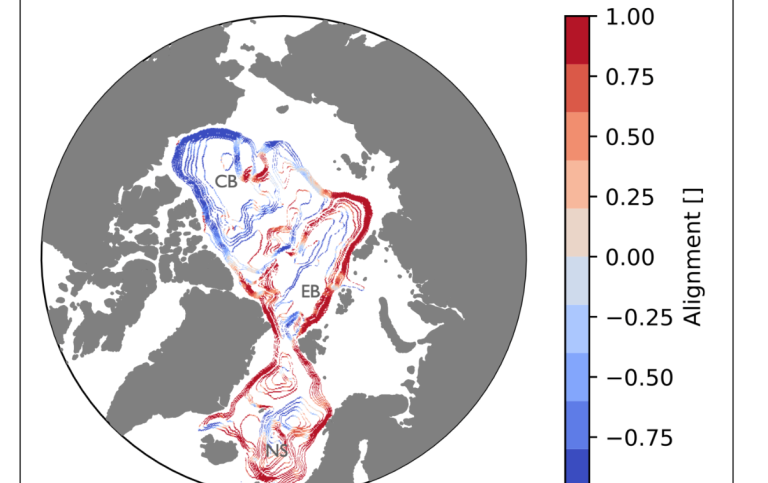
Nilsson, J., Kallmyr, J.-A.H. and Isachsen, P.E. (2024): Topographic Steering of the Upper Arctic Ocean Circulation by Deep Flows. Tellus A: Dynamic Meteorology and Oceanography, DOI: https://doi.org/10.16993/tellusa.4072
Chafik, L., M. Arthun, H. R. Langehaug, J. Nilsson, and T. Rossby, 2025: The Nordic Seas overturning is modulated by northward-propagating thermohaline anomalies. Communications Earth & Environment, 6(1), doi: 10.1038/s43247-025-02557-x
Sjur, A. L. P., P. E. Isachsen, J. Nilsson, J. H. LaCasce, and M. D. Ryseth, 2025: The Wind-Driven Time-Variable Circulation in the Arctic Mediterranean. Journal ofn Geophysical Research Oceans, 130(4), doi: 10.1029/2024JC021713