Research highlights 2024–25
Scientific articles that reflect the Bolin Centre different Research Themes.

Monsoon rainfall in East Asia has shifted abruptly in the past – and could do so in the future
RT1 | Monsoon rainfall in East Asia has shifted abruptly in the past – and could do so in the future
A study co-authored by Research Theme 1 member Qiong Zhang presents the most detailed reconstruction to date of East Asian summer monsoon rainfall over the past 22,000 years. The findings reveal a climate system marked not by gradual change, but by abrupt tipping points—sudden, large, and irreversible shifts in key components of the climate system. In this regard, rainfall over the region that persisted for thousands of years. The research provides new insight into how the monsoon system has responded to global climate disruptions in the past, raising concerns about the risks of future instability of the climate system under continued warming.
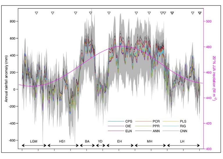
A natural archive reveals abrupt rainfall shifts
The study, representing the work of RT1, centres on a unique natural archive: Qingtongyam Maar Lake in southern China. As a closed-basin crater lake sensi-tive to local rainfall, it offers a high-resolution record of hydroclimate change. By applying nine independent statistical and machine learning methods to multiple geochemical and biological proxy records, the researchers were able to produce a robust reconstruction of annual rainfall anomalies, relative to the modern 1961–1990 average of 159mm.
The results show that East Asian summer monsoon rainfall was significantly higher during warm periods such as the Bølling–Allerød interstadial and the early to mid-Holocene; up to 440mm, or nearly 30%, above present-day levels. In contrast, the Last Glacial Maximum, Heinrich Stadial 1, the Younger Dryas, and the late Holocene were marked by notably drier conditions.
What makes this study particularly striking is the identification of five ma-jor climate tipping points, each representing a sharp and irreversible shift in monsoon rainfall. These transitions, occurring approximately 18,860, 14,640, 12,870, 11,360, and 4370 years before present, involved rainfall changes of nearly 400mm on average – an amount equivalent to roughly a quarter of the annual rainfall in the region. In several cases, these shifts happened within a few decades, yet their impacts lasted for millennia.
Global drivers behind monsoon tipping points
The drivers behind these tipping points appear to lie in broader Earth system changes. Two stand out in particular: the weakening of the Atlantic Meridion-al Overturning Circulation (AMOC) and the collapse of the so-called “Green Sahara.”
During Heinrich Stadial 1 and the Younger Dryas, for example, major slow-downs in the AMOC and its associated heat transport caused the interhemi-spheric temperature gradient to collapse, shifting tropical rain belts southward and suppressing the East Asian monsoon. Similarly, the demise of vegetation in North Africa around 4 000 years ago, which marked the end of the African Humid Period, led to increased Saharan dust, changes in the westerly winds over the North Atlantic, and cooling over the Tibetan Plateau. These cascading effects ultimately drove a significant weakening of the monsoon system.
Together, these findings underscore how the East Asian monsoon is not only sensitive to regional climate conditions, but also highly vulnerable to tipping elements in distant parts of the planet. The system behaves nonlinearly: it doesn’t simply follow a smooth response to changing temperatures or green-house gas concentrations, but instead jumps between relatively stable states, often in response to multiple interacting drivers.
What this means for future climate risks
This has significant implications for our understanding of future cli-mate risks. The monsoon provides critical rainfall to support agricul-ture and water supply for billions of people across East and Southeast Asia. If warming continues to disrupt ocean circulation or contributes to large-scale land surface changes, such as ongoing deforestation or desertification, the risk of triggering abrupt rainfall shifts could grow.
Importantly, this study moves beyond relying solely on oxygen iso-tope data from cave records, which are often difficult to interpret di-rectly in terms of rainfall amount. Instead, it provides a quantitative, multi-proxy, ensemble-based reconstruction that sets a new bench-mark for understanding long-term monsoon variability.
By linking past rainfall tipping points to global climatic drivers, the researchers offer not only a clearer view of how monsoons have be-haved over millennia, but also a warning that the future could hold similar abrupt shifts, should critical thresholds in the Earth system be crossed again.
This text is based on the scientific publication Tipping point-induced abrupt shifts in East Asian hydroclimate since the Last Glacial Maxi-mum, published in Nature Communications on 8 January 2025. The pa-per is accessible here: https://doi.org/10.1038/s41467-025-55888-w
Shedding new light on the role of forests in the climate and water cycle
RT1 | Shedding new light on the role of forests in the climate and water cycle
Forests are pivotal in terms of carbon storage and the water cycle, covering a third of the Earth's land surface. However, the full scope of their impact remains to be fully understood. A study led by members of Research Theme 1 have now been able to provide new insights into the complex role that forests play in the climate system and water cycle.
The research, involving scientists from eleven institutions across 5 countries, including Sweden, the UK, Finland, Germany, and Brazil, highlights the intri-cate relationship between forests, particularly their emission of organic gases, and the formation of reflective clouds that could influence global tempera-tures.
Comparing boreal and tropical forests
The unique aspect of this study is its focus on both boreal and tropical forests, which constitute 27% and 45% of the Earth's forested area, respectively. These ecosystems differ in their emissions and cloud formation processes, leading to varying impacts on the forest-cloud–climate feedback loop.
“This study, utilising long-term data from diverse forest environments in Fin-land and Brazil, marks the first time observational evidence has been present-ed for these interactions in tropical rainforests,” says lead author Sara Blich-ner, postdoctoral scientist at the Department of Environmental Science.

Underrepresentation of forests in climate models
The study emphasises the need for improved climate models to accurate-ly represent these complex interactions. “Our findings suggest that current models may underestimate the impact of forests on cloud formation and cli-mate, especially in tropical regions, which are crucial due to high amount of solar radiation these areas receive at these latitudes,” Blichner explains.
However, Blichner stresses that while the study highlights areas for improve-ment in climate modelling, it does not undermine the overall reliability of these models. “Climate models are highly trustworthy in representing the main processes of climate change. Our research aims to refine these models, reducing uncertainties in future climate projections,” she asserts.

Natural particles and global warming
The research also points out that as man-made particle emissions decrease due to air quality policies, the natural particles from forests become increas-ingly significant. These feedback loops are more potent in cleaner air environ-ments and could play an important role in moderating global warming.
This collaborative study underscores the need for continued research and im-provement in climate modelling to better predict future climate scenarios. Additionally, the findings highlight that these types of effects must be consid-ered when assessing forest conservation as a key strategy in climate change mitigation.
About forest emissions and climate regulation
Forests release substantial amounts of organic gases, particularly noticeable as the distinctive scent of a pine forest on a warm day. These gases, once re-leased into the atmosphere, contribute to particle formation.
Clouds are composed of minuscule water droplets, and each of these droplets nucleate around a particle in the air. An increase in atmospheric particles re-sults in clouds with more droplets, enhancing their reflectivity of sunlight and leading to cooler surface temperatures.
As climate change raises temperatures, forests are anticipated to emit more of these gases, thereby creating more particles and potentially more reflec-tive clouds.Clouds are composed of minuscule water droplets, and each of these droplets nucleate around a particle in the air. An increase in atmospheric particles re-sults in clouds with more droplets, enhancing their reflectivity of sunlight and leading to cooler surface temperatures.
As climate change raises temperatures, forests are anticipated to emit more of these gases, thereby creating more particles and potentially more reflec-tive clouds.
This research highlight is based on the scientific paper Process-evaluation of forest aerosol-cloud-climate feedback shows clear evidence from observations and large uncertainty in models.
The paper is accessible here: https://doi.org/10.1038/s41467-024-45001-y
Unravelling the potential of context- based storylines
RT2 | Unravelling the potential of context-based storylines: towards ecosystem-based land use planning for the Tagliamento River
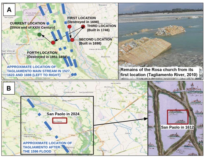
Members of Research Theme 2 have explored how historical land use changes in the Tagliamento River basin – a reference ecosystem for the restoration of Alpine rivers – have influenced flood risk and ecosystem functionality, and how future planning can better integrate both risk reduction and river conservation. The Tagliamento River in northeast Italy is used as a reference model for river restoration in Alpine environments due to its largely unaltered hydromorphological features.
However, urban expansion, infrastructure development, and agricultural land conversion have disrupted natural floodplain processes. This article analyses how land use evolution has altered the capacity of floodplains to absorb and buffer floodwaters over time. To do this, the study incorporates context-based storylines of local knowledge and historical documentation for two villages affected by flood events: one that was relocated across the river after flood events, and a second that became isolated as an island, surrounded by braid-ed channels. These changes provide concrete, narrative-based insights into how communities have historically adapted to the dynamic nature of the river and highlight the need to integrate local experiences and place-based historical data into current and future flood risk management strategies.

The middle course of the Tagliamento has preserved natural river dynam-ics, such as sediment transport, meandering, and seasonal flooding, which allow for the preservation of natural flood regulation functions. In contrast, the lower course has been more heavily constrained by levees and urban de-velopment. The study suggests opportunities exist to reactivate historical fluvial corridors and wetlands. The two village examples highlight that flood risk adaptation should not rely solely on structural defences like levees. While these measures may offer short-term protection, they often encourage devel-opment in high-exposure areas and disconnect the river from its floodplain. Instead, prioritising the restoration of floodplain functions through ecosystem-based land use planning can deliver co-benefits such as biodiversity con-servation, groundwater recharge, and climate resilience.
While flood risk is a central concern in the Tagliamento basin, other hazards like droughts and coastal floods (e.g., from sea-level rise or storm surges) can interact with flooding in compounding or cascading ways. Planning should therefore adopt a multi-hazard perspective, considering multiple, interacting hazards, rather than focusing on floods in isolation. An approach to land use and multi-risk planning is advocated for that draws on historical and local knowledge, accounts for the complexity of hazard interactions, prioritises ecosystem functions and aims to reconcile river conservation with risk reduc-tion goals. Context-dependent storylines such as the ones discussed in this article make complex hydrological and planning concepts more accessible to communities and decision-makers, enhancing risk awareness and supporting more inclusive governance.
This popular science summary is based on the scientific paper: Unravelling the Potential of Context-Based Storylines: Towards ecosystem-based land use planning for the Tagliamento River, northeastern Italy. The paper is accessible here: https://doi.org/10.21463/shima.236
A first-ever full greenhouse gas budget
RT2 | A first-ever full greenhouse gas budget for permafrost region shows emissions from wetlands and fires offset Boreal Forest uptake
Arctic and Boreal regions are among the most rapidly changing parts of Earth. The northern permafrost region, characterised by permanently frozen soil, is warming two-to-four times faster than the global average. This region is also a key component of global biogeochemical and hydrological cycles.
The northern permafrost region covers large areas, 17 million km2, and stores very large amounts of carbon and nitrogen in soils and sediments. With climate change, there is concern that thawing permafrost will release greenhouse gases into the atmosphere, shifting the region from long-term cooling of the global climate to a net warming effect.
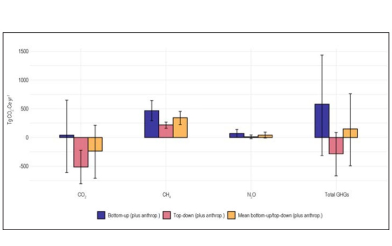
To determine the current greenhouse gas budgets of permafrost ecosystems, Hugelius et al. (2024) used different techniques to assess carbon dioxide, methane, and nitrous oxide for the 2000–2020 time period. Performed as part of an international effort under the Global Carbon Project, this study was the first combined permafrost region greenhouse gas budget. A team of scientists from 35 research institutions compiled and assessed all available observations and modelling of greenhouse gas emissions on land, in freshwater, and in the atmosphere. A particular focus was to compare different methods for generating budgets, particularly contrasting “bottom-up ” ecosystem modelling approaches to “top-down” modelling based on atmospheric measurement and transport models. Overall, it is still not possible to reconcile the two approaches, with bottom-up approaches generally predicting more net greenhouse gas release.
Combining the different methods, the study concludes that the region is a net sink of carbon dioxide; mainly located in boreal forests and wetlands. However, carbon dioxide is emitted from inland waters and fires affecting both forest and tundra, giving a near neutral full carbon dioxide budget. Lakes and wetlands are strong sources of methane, which contributes to significantly warming the climate, especially over shorter timescales. Nitrous oxide is emitted at low rates across the region, with a relatively limited impact on climate.
In summary, the climate warming from the northern permafrost region is likely close to neutral when calculated over a 100-year time window, but it warms the climate when calculated over a 20-year time window.
This text is a popular science summary based on the scientific paper Permafrost region greenhouse gas budgets suggest a weak CO2 sink and CH4 and N2O sources, but magnitudes differ between top-down and bottom-up methods, accessible here: https://doi.org/10.1029/2023GB007969
Phanerozoic atmospheric CO2 reconstruction: current insights and future directions
RT3 | Phanerozoic atmospheric CO2 reconstruction: current insights and future directions
Understanding how atmospheric CO2 levels have changed throughout Earth’s history is critical for predicting how the Earth System might respond to rising CO2 in the future. Steinthorsdottir et al. (2025) have reviewed and synthesised current knowledge on the proxies and models used to reconstruct paleo-CO2, recent advances in the field, and key directions for future research.
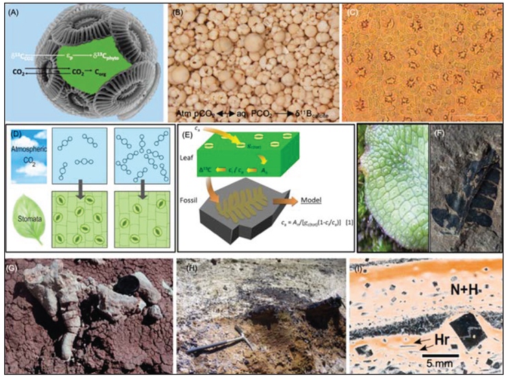
A range of marine and terrestrial proxies – such as paleosols (ancient soils), stomatal features of fossilised plant leaves, and carbon isotopic compositions
– are used to infer past CO2 levels. Each proxy encodes the atmospheric CO2 signal through distinct physiological or geochemical mechanisms. The accura-cy of these reconstructions is constrained by assumptions about ancient en-vironmental conditions, biological processes, and post-depositional changes. The review details how proxies are linked to atmospheric CO2 and highlights ongoing efforts to refine proxy application and validation, especially through forward proxy system models.
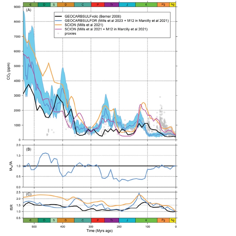
A major advancement highlighted in this review is the compilation of all 4077 published paleo-CO2 estimates from the Phanerozoic Eon (the last ~540 mil-lion years), which captures first-order trends but also reveals significant varia-bility and uncertainty across many intervals. This scatter underscores the need for better constraining of proxy sensitivities and a more systematic approach to quantifying uncertainty. Advances in this area are being driven by the CO2 Proxy Integration Project (CO2PIP), which seeks to modernise and standardise proxy datasets, particularly for pre-Cenozoic eras, using contemporary proxy theory and FAIR data principles.
A significant breakthrough in paleo-CO2 reconstruction is the development of a high-resolution Cenozoic Era (the past 66 million years) CO2 curve by the CenCO2PIP Consortium. This record establishes a new benchmark for post-Paleocene atmospheric CO2 evolution and demonstrates the benefits of integrating multi-proxy datasets within a robust statistical and mechanistic framework. The ongoing second phase of CO2PIP aims to extend this approach across the entire Phanerozoic by developing proxy-specific models that ac-count for ecological and diagenetic controls on the CO2 signal, ultimately ena-bling data-driven reconstructions via inversion modelling.
Carbon cycle models – such as the GEOCARB, COPSE, and SCION frameworks – remain central to quantifying long-term CO2 evolution. These models simulate the transfer of carbon among Earth's reservoirs and provide critical context for interpreting proxy records. Recent developments focus on reducing model uncertainty by refining representations of climate sensitivity, silicate weath-ering, vegetation dynamics, and lithological heterogeneity. Notably, spatially explicit modelling efforts have improved reconstructions for the Cretaceous–Cenozoic interval, aligning model outputs more closely with proxy data.
Emerging directions in modelling include enhancing the spatial and tempo-ral resolution of input data, integrating non-silicate and reverse weathering processes, and better constraining the feedback between climate and carbon cycle processes. These improvements aim to reconcile persistent data – model mismatches and to yield more accurate simulations of CO2 – climate linkages.
Looking forward, the paleo-CO2 research community is advancing toward a next-generation, statistically integrated, multi-proxy CO2 reconstruction for the Phanerozoic. Central to this effort is the development of a curated, up-datable community archive hosted at paleo-co2.org, which includes metada-ta-rich proxy records and tools for standardised data submission and vetting.
The integration of forward proxy models, high-resolution datasets, and improved carbon cycle modelling holds promise for resolving outstanding questions about the Earth’s CO2 history, and its climatic and biogeochemical impacts.
This text is based on the scientific publication: Phanerozoic atmospheric CO2 reconstructed with proxies and models: Current understanding and future directions, accessible here: https://doi.org/10.1016/B978-0-323-99762-1.00074-7
RT3 | Climate, food and death: temperature-related mortality in pre-industrial Sweden
Climate variability has long been recognised as a significant factor influencing human health, particularly in pre-industrial societies dependent on agriculture, and vulnerable to environmental fluctuations. Despite this, climatic impacts on mortality in the past remain poorly understood. Chen et al. examines the relationship between seasonal temperature variations and mortality rates in Sweden during the 1750–1859 time period, a time before modern medical and social interventions.
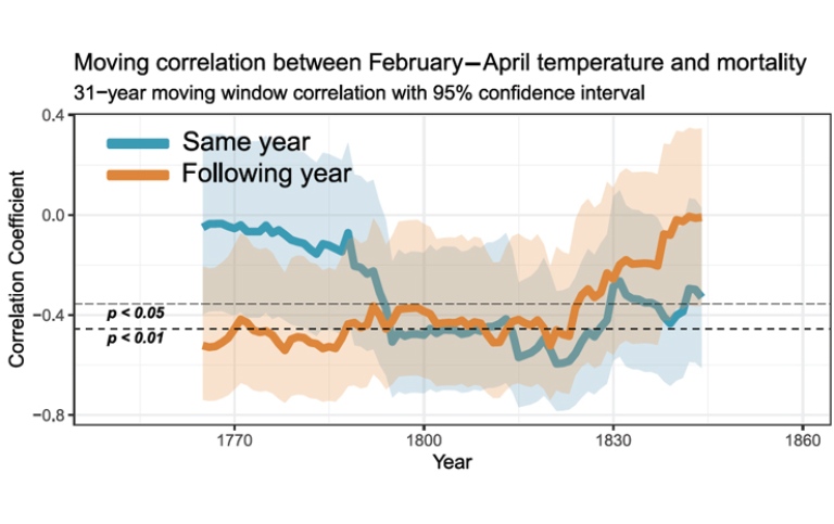
The study investigates the relationship between temperature and mortality in Sweden during 1750–1859, providing new insights into how seasonal climatic variations influenced population health in the pre-industrial era. By analysing historical mortality records alongside reconstructed temperature data, they find a statistically significant connection between colder temperatures in late winter and spring and increased mortality rates not only within the same year but also extending into the following year.
The researchers find that temperatures during February, March, and April have a particularly strong impact on mortality. The effect of cold temperatures dur-ing these months manifests both as immediate increases in deaths within the same calendar year and as delayed effects observable in mortality figures for the subsequent year. These findings suggest that temperature-driven mortal-ity is not merely an acute phenomenon but also involves longer-term conse-quences, likely linked to food production and nutritional status.
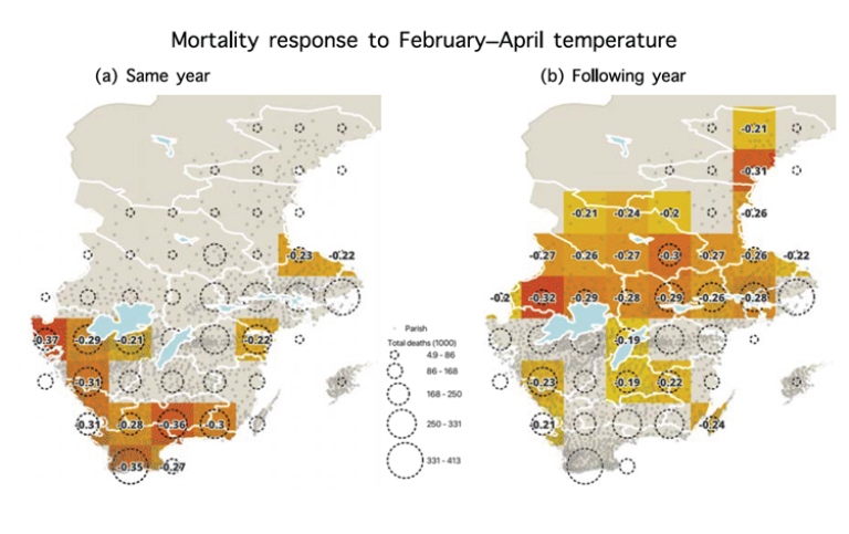
Geographical differences emerged clearly in the temperature–mortality re-lationship. In southern Sweden, the influence of temperature was strongest on mortality within the same year, implying that the immediate physiological stresses caused by cold temperatures played a major role. In contrast, cen-tral Sweden exhibited more pronounced temperature effects on mortality in the following year, indicating that food production disruptions – caused by cold winters and late springs – may have led to malnutrition and increased vulnerability over a longer time horizon. This geographical pattern suggests that the southernmost regions were somewhat buffered from harvest-related mortality delays, likely due to their relatively less climate-sensitive agricultural conditions.
The researchers further examine age-specific mortality responses, revealing distinct vulnerability patterns across demographic groups. Child mortality was particularly affected by cold late winter and spring conditions in the previous year, consistent with nutritional deficiencies resulting from poor harvests and food shortages. In contrast, mortality among the elderly showed a more im-mediate response to cold temperatures within the same year, likely driven by increased incidence of respiratory and cardiovascular illnesses aggravated by cold stress. Adults in the intermediate age group also experienced increased mortality linked to temperature variability, reflecting a combination of direct and indirect effects.
Importantly, the temperature–mortality relationship changed over time. After the 1820s, the association weakened substan-tially, particularly concerning mortality in the year following cold conditions. This decline is interpreted as evidence of im-proved food and nutrition security, as well as advances in pub-lic health, such as vaccination programmes, which collectively enhanced population resilience to climatic stressors.
The study’s methodological approach employs advanced statis-tical modelling to estimate excess mortality, using quasi-Pois-son regression models, which account for long-term trends and inter-annual variability more effectively than simple baseline methods (e.g., five-year averages). This enhances the reliability of detected climate–mortality associations in a period charac-terised by complex mortality dynamics, including epidemics and wars.
In sum, this study underscores the significant role of late win-ter and early spring temperatures in shaping mortality patterns in 18th- and 19th-century Sweden, highlighting how climatic stressors interacted with regional agricultural conditions and demographic vulnerabilities. The observed spatial and tempo-ral variations in climate sensitivity provide valuable historical perspectives on how societies have adapted to environmen-tal challenges. These findings contribute to broader efforts to understand the long-term impacts of climate variability on human health and inform discussions about resilience in the face of ongoing climate change.
This text is a popular science summary based on the scientific publication: Cli-matic impacts on mortality in pre-industrial Sweden. The paper is accessible here: https://doi.org/10.5194/cp-21-185-2025
Elevated temperatures affect bumblebee foraging and flight speed
RT4 | Elevated temperatures affect bumblebee foraging and flight speed
As global temperatures rise, the health of ecosystems reliant on robust pollinator activities are at risk. Amongst pollinators, bumblebees are vital players that are increasingly threatened by climate change. This study, led by members of RT4, examines how elevated temperatures influence the foraging behaviour of bumblebees, shedding light on potential disruptions to critical plant–insect interactions.

In a controlled laboratory experiment, bumblebees were studied at two am-bient temperatures: 24°C, considered optimal for foraging, and 32°C, which is considered a stressful temperature. Bumblebee colonies were alternated between these two temperatures weekly, allowing us to observe tempera-ture-related changes in foraging behaviour with artificial plants. We meas-ured flower visitation rate and time, total foraging time, flight speed, and the energy expended while flying (i.e., metabolic rate).
The findings revealed significant behavioural changes at 32˚C. Bumblebees exhibited a higher flower visitation rate and increased flight speed at 32°C compared to 24°C. However, the time spent on each flower decreased as the temperature rose, leading to an overall decrease on foraging time spent by individuals. This suggests that while bees were quicker, they faced additional stress that may have limited their foraging time.
One possible explanation for these changes in behaviour is linked to the met-abolic rate of flying bees, which decreases with higher temperatures. At 32°C, bees expend less energy to achieve the necessary body temperature for flight, allowing for faster and more frequent movements. Yet, the reduced flight ac-tivity indicates potential heat stress, suggesting that bumblebees may face challenges while foraging at elevated temperatures.
The findings of this study suggest potential disruptions to plant–animal in-teractions. Changes in foraging behaviour could disturb the delicate balance between bees and the plants they pollinate, potentially leading to cascading effects on both wild plant communities and agricultural production. As bum-blebees make fewer trips and spend less time on flowers, the quantity and quality of pollination could decline, ultimately impacting food availability and biodiversity.
While this study provides valuable insights into how temperature impacts foraging behaviours in bumblebees, it also points to the need for further re-search. Understanding how temperature continues to affect pollination ser-vices will be crucial in addressing threats to biodiversity and global food se-curity. With ongoing climate change, the survival of these crucial pollinators and the ecosystems that depend on them hangs in the balance, highlighting an urgent need to address our warming planet's implications for plant–animal interactions.
This text is a popular science summary of the scientific paper Experimental elevated temperature affects bumblebee foraging and flight speed, accessible here: https://royalsocietypublishing.org/doi/10.1098/rspb.2024.1598
Love your wet grass: why the resilience of different grazing areas matters for pastoralism
RT4 | Love your wet grass: why the resilience of different grazing areas matters for pastoralism
In eastern Africa, livestock is often grazed on vast areas of land that provide grassy and woody vegetation for herds to forage upon. Migratory movements by pastoralists and their livestock herds are therefore highly important, as they follow green flushes after rainfall and let the grazed areas rest. In recent years, changing pastoralist practices and rainfall patterns as well as ever increasing livestock population have led to local overgrazing, and accordingly, degradation in many rangeland areas. This makes it difficult for the grassy layer to recover from high grazing pressure.
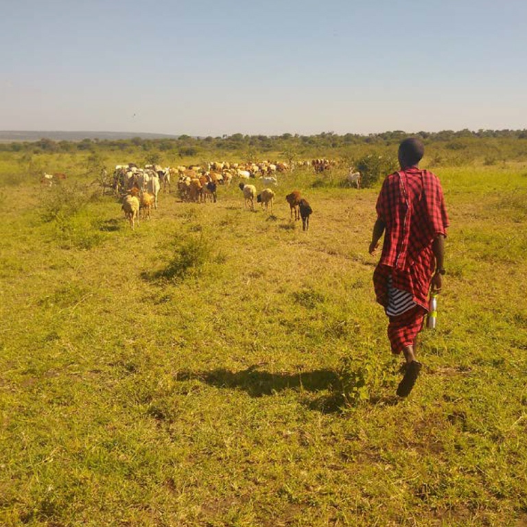
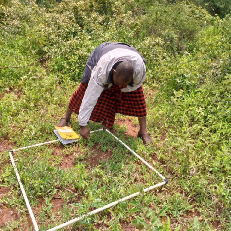
To test how different grazing practices and increasing livestock pressure affects the rangeland plant recovery, we established a clipping experiment in three rangeland management types: rangeland that was grazed during the rainy sea-son, rangeland grazed during the dry season, and seasonal exclosures (i.e., ex-cluding livestock from degraded sites), in the Maasai Steppe, northern Tanzania. To better resemble grazing pressure in the model, we clipped grasses down to ground level every month and alternatively, we clipped only once per growing period in a fenced and open grazing area over two consecutive growing periods.
We found that the grasses in the rangeland that were grazed during the rainy season had the lowest regrowth rates and poorest vegetation cover. When rain-fall was low, seasonal exclosures showed the best vegetation regrowth. Also, plots that were seasonally clipped showed better vegetation that those that were clipped monthly, showing how important a resting period is. Excluding grazing livestock had a large positive impact on vegetation only when rainfall was high but did not show much recovery potential when rainfall was low.
We conclude that traditional seasonal migratory herding is important for a long-lasting rangeland productivity and resilience under increasing intensity of disturbance. We highlight the differences in grass recovery rate, depending on location, resting time, and duration as well as rainfall conditions. Dry season grazing (providing rest to the grasses during the rainy season) proved to be the most sustainable concept for maintaining regrowth and controlling erosion of these rangelands.
This text is a popular science summary of the scientific paper Love your wet grass! Dry season grazing reserves show highest grass regrowth in communal semi-arid rangelands of Tanzania.
The paper is accessible here: https://doi.org/10.1371/journal.pone.0313818
Last updated: October 29, 2025
Source: Bolin Centre for Climate Research